
The Feathered Hat
Active member
Trails: Moriah Brook, Carter-Moriah, Kenduskeag, Shelburne
Total miles: 15
Time: 10 hours*
Steve Smith, in his book "The 4,000-Footers of the White Mountains," describes the 15-mile loop over these two peaks from a start at the Wild River campground as "spectacular," and for good reason: not only does the loop hike provide superlative views from the ledges and summits of Moriah and Shelburne-Moriah, but it also includes the beautiful Moriah Brook Trail (which I had heard from a second-hand source is one of Steve's favorites) and the nearly equally nice southern leg of the Shelburne Trail. It's a great introduction to the Wild River Wilderness.
But it's a butt-kicker too, especially yesterday when the heat and humidity felt as heavy to Tuckerman and me as a hot, wet wool blanket. We both sweated buckets.
Things began wonderfully, though. Out of the campground a quarter-mile or so, an excellent suspension bridge...
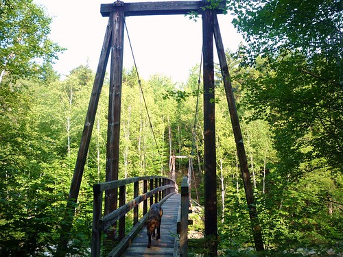
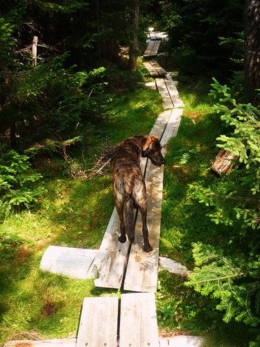
... crosses the Wild River, and in another quarter-mile the Moriah Brook Trail begins its long meander up to the junction with the Carter-Moriah Trail, more than five miles away. This trail is as advertised: it crosses through a gorgeous birch wood, hugs close to Moriah Brook much of the way, and features several refreshing water crossings, all of them rock-hoppable right now.
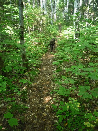
From about the 2,500-foot level up to the junction, which is at the 3,000-foot elevation, things get a little steep, but overall the Moriah Brook Trail is about the nicest way to gain 2,000 elevation feet you can imagine. Muddy in spots, and very muddy in two or three, but overall just a delight.
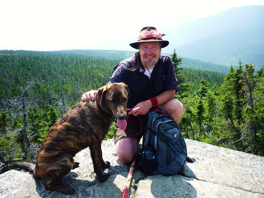
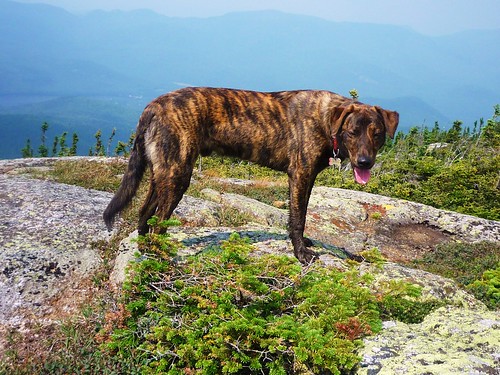
We began to feel the effects of the day's heat and humidity on the steep climb up the Carter-Moriah Trail from the junction up to the ledges below Moriah's summit and took several short breathers. A small but cooling breeze occasionally rippled our hair up on the ledges and on the summit, and thank goodness for that. On the peak we enjoyed lunch in the company of two gentlemen who had climbed up from the Carter-Moriah trailhead in Gorham, and Tuckerman had his 10th of the NH48...
Then we got on to the business of our next goal: Shelburne-Moriah Mountain. The best thing about the stretch of the Kenduskeag Trail from Mt. Moriah to the junction with the Rattle River Trail, is that along its 1.4-mile length there are a zillion excellent puncheons -- maybe as much as a quarter-mile, or perhaps even more, of the route is on these well-constructed bog bridges.
After the Rattle River Trail junction, where we met a couple of guys who wound up being the last people we saw on the trail for the rest of the day, we began the steady climb up to the summit of Shelburne-Moriah Mountain...
Now the heat and humidity really began to wear us down, and I was getting worried about water. I had about a cup of water, total, left in my water bottles, but I was worried more about Tuck, who had been occasionally slurping water from sketchy sources where we found them, which wasn't often. I knew that once we got to the Shelburne Trail we would find water down that route, but our junction with the Shelburne was still more than a mile away. But near the summit of Shelburne-Moriah I found a tiny but deep rain pocket that might've held about a quart of water. Tuck drank about half of it before the precious water got too thick with mud for his taste. He had been flagging a bit but the rain water revived him.
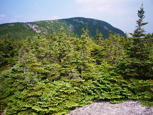
We finally reached the junction with the Shelburne Trail at just after 4 p.m. It had taken us four and a half hours to cover the five and a half miles from the Moriah Brook/Carter-Moriah trail junction. But even under the best of conditions this stretch is brutal: it begins with the 1,000-foot climb to the Moriah summit, then drops 800 feet down into a col below Middle Moriah (and the first 400 feet of that drop are very steep), then climbs 500 feet to the summit of Shelburne-Moriah, then drops 1,000 very steep feet down to the Shelburne Trail junction. That's a lot of elevation change in a few miles, and on a hot, humid day the heavy, heated moisture sucked the energy right out of both of us.
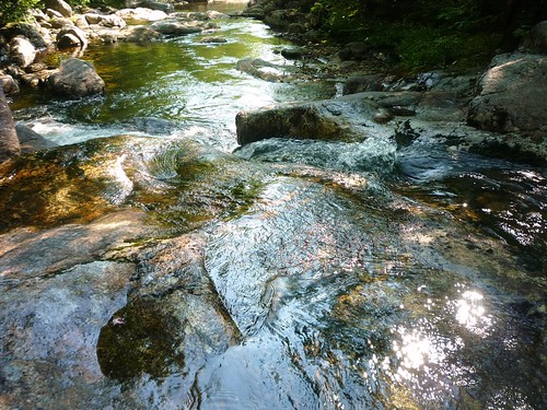
About a half-mile down the Shelburne Trail we came to a tiny stream and I immediately filled both of my water bottles while Tuckerman drank and drank and drank. The little pool I drew the water from was a bit muddy and mossy, but let me tell you, I've never tasted sweeter water! I was hungry, too, and reached into my pack for an energy bar, but somewhere along the line I must've dropped it. Then I remembered I had a packet of Jell-O in my pack for just this kind of emergency, so mixed the peach flavoring into one of the bottles and immediately drank about half of it. Ahhhhh! Fully revived, Tuck and I made short work of the remainder of the Shelburne Trail, which, after about the 2,300-foot level descends exceptionally gently through a beautiful hardwood forest.
When we finally reached the bottom of the Shelburne and its junction with the Highwater Trail, I decided we would ford the Wild River and road-walk back to the trailhead, which would save us about 0.7 of a mile compared to taking trails the whole way. If the river required a boots-off crossing, so much the better; both Tuck and I could use a swim. The crossing was pretty much rock-hoppable, though (three times I had to step on rocks that were a couple inches below the surface).
We saw a total 13 people on the trail all day: 7 on the Moriah Brook Trail, 4 on the Moriah summit, and 2 on the Kenduskeag Trail. The smart people, it seems, were at home in air-conditioned comfort.
Despite hiking the loop on a nastily humid day -- I'm still feeling a bit whipped this morning, and Tuckerman hasn't left his spot in front of the fan since last night -- I understand why Steve thinks this is such a great hike and in fact I'm anxious to do it again. In the fall this would be a spectacular route indeed.
By the way, on the drive home we got detoured over to country roads on the north side of the Androscoggin River due to a big train derailment on the tracks beside U.S. Highway 2 east of Gorham. Oh, and just for kicks I stepped on the scale back home: yowza, I had sweated off seven pounds!
More photos:
http://www.flickr.com/photos/99682097@N00/sets/72157621938737229/
* Sunday's heat and humidity added about 90 minutes to our time, I estimate, due to a couple extra stops to pump water but mostly to take lots of breathers, which got longer as the day went on.
Steve B
The Feathered Hat
[email protected]
________________________________
Tuckerman's report for dogs:
Lots of water crossings and lots of mud on the Moriah Brook Trail. Cool!
No water crossings and hardly any water over Moriah and Shelburne-Moriah. Not cool!
Water again on the Shelburne Trail. Yay!
Moose poop. Sticks. Bugs. Frogs.
*** Three sniffs (out of four). T-Dog says check it out. (But do it on a day that's not as hot as yesterday!)
Total miles: 15
Time: 10 hours*
Steve Smith, in his book "The 4,000-Footers of the White Mountains," describes the 15-mile loop over these two peaks from a start at the Wild River campground as "spectacular," and for good reason: not only does the loop hike provide superlative views from the ledges and summits of Moriah and Shelburne-Moriah, but it also includes the beautiful Moriah Brook Trail (which I had heard from a second-hand source is one of Steve's favorites) and the nearly equally nice southern leg of the Shelburne Trail. It's a great introduction to the Wild River Wilderness.
But it's a butt-kicker too, especially yesterday when the heat and humidity felt as heavy to Tuckerman and me as a hot, wet wool blanket. We both sweated buckets.
Things began wonderfully, though. Out of the campground a quarter-mile or so, an excellent suspension bridge...
... crosses the Wild River, and in another quarter-mile the Moriah Brook Trail begins its long meander up to the junction with the Carter-Moriah Trail, more than five miles away. This trail is as advertised: it crosses through a gorgeous birch wood, hugs close to Moriah Brook much of the way, and features several refreshing water crossings, all of them rock-hoppable right now.
From about the 2,500-foot level up to the junction, which is at the 3,000-foot elevation, things get a little steep, but overall the Moriah Brook Trail is about the nicest way to gain 2,000 elevation feet you can imagine. Muddy in spots, and very muddy in two or three, but overall just a delight.
We began to feel the effects of the day's heat and humidity on the steep climb up the Carter-Moriah Trail from the junction up to the ledges below Moriah's summit and took several short breathers. A small but cooling breeze occasionally rippled our hair up on the ledges and on the summit, and thank goodness for that. On the peak we enjoyed lunch in the company of two gentlemen who had climbed up from the Carter-Moriah trailhead in Gorham, and Tuckerman had his 10th of the NH48...
Then we got on to the business of our next goal: Shelburne-Moriah Mountain. The best thing about the stretch of the Kenduskeag Trail from Mt. Moriah to the junction with the Rattle River Trail, is that along its 1.4-mile length there are a zillion excellent puncheons -- maybe as much as a quarter-mile, or perhaps even more, of the route is on these well-constructed bog bridges.
After the Rattle River Trail junction, where we met a couple of guys who wound up being the last people we saw on the trail for the rest of the day, we began the steady climb up to the summit of Shelburne-Moriah Mountain...
Now the heat and humidity really began to wear us down, and I was getting worried about water. I had about a cup of water, total, left in my water bottles, but I was worried more about Tuck, who had been occasionally slurping water from sketchy sources where we found them, which wasn't often. I knew that once we got to the Shelburne Trail we would find water down that route, but our junction with the Shelburne was still more than a mile away. But near the summit of Shelburne-Moriah I found a tiny but deep rain pocket that might've held about a quart of water. Tuck drank about half of it before the precious water got too thick with mud for his taste. He had been flagging a bit but the rain water revived him.
We finally reached the junction with the Shelburne Trail at just after 4 p.m. It had taken us four and a half hours to cover the five and a half miles from the Moriah Brook/Carter-Moriah trail junction. But even under the best of conditions this stretch is brutal: it begins with the 1,000-foot climb to the Moriah summit, then drops 800 feet down into a col below Middle Moriah (and the first 400 feet of that drop are very steep), then climbs 500 feet to the summit of Shelburne-Moriah, then drops 1,000 very steep feet down to the Shelburne Trail junction. That's a lot of elevation change in a few miles, and on a hot, humid day the heavy, heated moisture sucked the energy right out of both of us.
About a half-mile down the Shelburne Trail we came to a tiny stream and I immediately filled both of my water bottles while Tuckerman drank and drank and drank. The little pool I drew the water from was a bit muddy and mossy, but let me tell you, I've never tasted sweeter water! I was hungry, too, and reached into my pack for an energy bar, but somewhere along the line I must've dropped it. Then I remembered I had a packet of Jell-O in my pack for just this kind of emergency, so mixed the peach flavoring into one of the bottles and immediately drank about half of it. Ahhhhh! Fully revived, Tuck and I made short work of the remainder of the Shelburne Trail, which, after about the 2,300-foot level descends exceptionally gently through a beautiful hardwood forest.
When we finally reached the bottom of the Shelburne and its junction with the Highwater Trail, I decided we would ford the Wild River and road-walk back to the trailhead, which would save us about 0.7 of a mile compared to taking trails the whole way. If the river required a boots-off crossing, so much the better; both Tuck and I could use a swim. The crossing was pretty much rock-hoppable, though (three times I had to step on rocks that were a couple inches below the surface).
We saw a total 13 people on the trail all day: 7 on the Moriah Brook Trail, 4 on the Moriah summit, and 2 on the Kenduskeag Trail. The smart people, it seems, were at home in air-conditioned comfort.
Despite hiking the loop on a nastily humid day -- I'm still feeling a bit whipped this morning, and Tuckerman hasn't left his spot in front of the fan since last night -- I understand why Steve thinks this is such a great hike and in fact I'm anxious to do it again. In the fall this would be a spectacular route indeed.
By the way, on the drive home we got detoured over to country roads on the north side of the Androscoggin River due to a big train derailment on the tracks beside U.S. Highway 2 east of Gorham. Oh, and just for kicks I stepped on the scale back home: yowza, I had sweated off seven pounds!
More photos:
http://www.flickr.com/photos/99682097@N00/sets/72157621938737229/
* Sunday's heat and humidity added about 90 minutes to our time, I estimate, due to a couple extra stops to pump water but mostly to take lots of breathers, which got longer as the day went on.
Steve B
The Feathered Hat
[email protected]
________________________________
Tuckerman's report for dogs:
Lots of water crossings and lots of mud on the Moriah Brook Trail. Cool!
No water crossings and hardly any water over Moriah and Shelburne-Moriah. Not cool!
Water again on the Shelburne Trail. Yay!
Moose poop. Sticks. Bugs. Frogs.
*** Three sniffs (out of four). T-Dog says check it out. (But do it on a day that's not as hot as yesterday!)
Last edited:
")