
DMOutdoors
New member
Distance: 10.6 miles
Elevation Gain: 5,050 ft
Book Time: 8hrs 40min
Tuckerman Ravine, Lions Head Trail, Crawford Path, Monroe Loop, Camel Trail, Davis Path, Boott Spur Trail
Hi everyone! This is my first trip report post on Views from the Top. I have been reading many of the threads since becoming a member, and I am amazed at how much information is here. I look forward to contributing. It was a beautiful and quiet Sunday to be above treeline. I couldn't have asked for any better weather. I did the same hike in October, and I enjoyed it so much, I decided to return in November, both times solo.
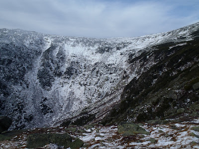
I took the Tuckerman Ravine Trail to the regular Lion's Head trail. From Pinkham all of the way up to Lion's Head was bare-bootable. In the ravine, the snow is slowly filling in, and some vertical ice was starting to form.
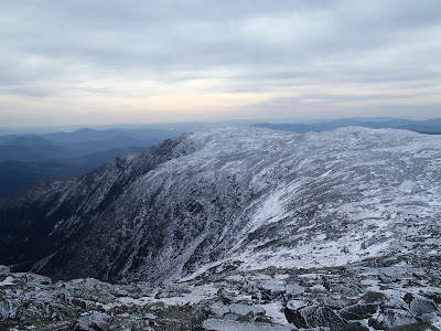
From the top of the Ravine. I couldn't keep my eyes off the beautiful sky and the view as I ascended Mt. Washington for the 3rd time this year.
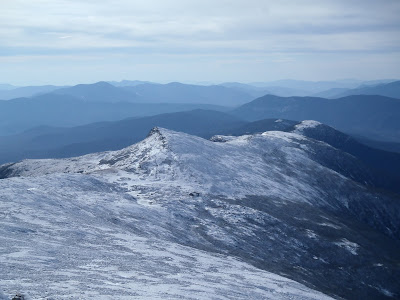
A nice close-up of the ice covered ridge of the southern Presi's. This is one of my favorite vantage points in the Whites...
You can check out my full report and access the full album on my blog posting .
Elevation Gain: 5,050 ft
Book Time: 8hrs 40min
Tuckerman Ravine, Lions Head Trail, Crawford Path, Monroe Loop, Camel Trail, Davis Path, Boott Spur Trail
Hi everyone! This is my first trip report post on Views from the Top. I have been reading many of the threads since becoming a member, and I am amazed at how much information is here. I look forward to contributing. It was a beautiful and quiet Sunday to be above treeline. I couldn't have asked for any better weather. I did the same hike in October, and I enjoyed it so much, I decided to return in November, both times solo.
I took the Tuckerman Ravine Trail to the regular Lion's Head trail. From Pinkham all of the way up to Lion's Head was bare-bootable. In the ravine, the snow is slowly filling in, and some vertical ice was starting to form.
From the top of the Ravine. I couldn't keep my eyes off the beautiful sky and the view as I ascended Mt. Washington for the 3rd time this year.
A nice close-up of the ice covered ridge of the southern Presi's. This is one of my favorite vantage points in the Whites...
You can check out my full report and access the full album on my blog posting .
