Questions Regarding Walker Ravine

vftt.org

Help Support vftt.org:

This site may earn a commission from merchant affiliate links, including eBay, Amazon, and others.

1HappyHiker

Well-known member
Joined
Jan 18, 2007
Messages
1,973
Reaction score
405
Location
Bethlehem, NH
Background:
Having only about 4 hours to “play outside” yesterday, I took a short stroll (bushwhack, if you will) along Walker Brook and into the Walker Ravine. You know, it’s that “little” ravine on the west side of the Lafayette/Lincoln stretch of the Franconia Ridge.

Anyway, I was surprised to find very distinct remnants of a trail, particularly on the north side of the brook before the point where it splits into a north and south branch. I meandered up the south branch to about 3200 ft of elevation before hitting my turnaround time. It’s pretty open in there and very easy going. I could easily have gone further if only I had the time.

I was surprised to have found remnants of a trail. So, as soon as I got home, I checked Guy Waterman’s booklet entitled: An Outline of Trail Development in the White Mountains. Here I read that there used to be a trail in that area called the Walker Ravine Trail (appropriately enough!!). However, Guy’s booklet indicates that this trail no longer appeared on AMC maps after the 1928 edition of the WMG.

Questions:
So, with that rather long introduction, here are my questions.

1) If someone has a 1928 edition of the WMG (or earlier), would you be kind enough to post information about this trail, such as where it began and ended, etc, etc?

2) Has anyone whacked up the south branch of Walker Brook beyond 3200 feet, like maybe to the headwall of the ravine (or beyond)? I’m trying to determine if it’s worth a return visit to go beyond where I stopped. I know this is purely a subjective determination, but I’d be interested in any input.

Below is a photo taken from the point where I ended my whack. So, I’m curious what can be seen further up the ravine.
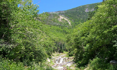
100_2547.JPG
 
2) Has anyone whacked up the south branch of Walker Brook beyond 3200 feet, like maybe to the headwall of the ravine (or beyond)? I’m trying to determine if it’s worth a return visit to go beyond where I stopped. I know this is purely a subjective determination, but I’d be interested in any input.

The southern branch is the area sometimes referred to as the "Lincoln's Throat Slide". Here's a link to a trip report that Craig posted a while back.

Jason
 
The fold out map bound in my 1918 (2nd edition) WMG, shows a trail going up Walker Ravine and dead ending. There is no topo on this map and it doesnt show the Old Bridal Path (it was abandoned at this time and not recomended for hiking). Its interesting to note that the guide mentions that the USGS maps for this area were not yet available. I could find no written description of this trail.

In later editions, it mentions that the Old Bridal path was impassable due to extensive logging in the area. I would speculate that the trail along Walker Brook may be an old logging road, or a trail that was turned into one.

The area of map in question is about 3/4" across and I had to use a magnifying lens to read it, but it shows a dotted line alongside the north side of the brook. AMC did offer larger scale blueprint maps (blue background, white lines for trails) of the foldout maps but the few I have dont really show any more details than the fold outs.
 
Walker Ravine and stuff

I have whacked extensively in that area and there is a large network of old logging drag roads in there. The network terminates on the Falling Waters trail just before you cross the last brook down low heading in (Dry Brook). It came in on the left and joins the old logging road, now the trail, and continued down the trail across the brook and then continued straight where the Falling Waters trail turns left. I have entered the network both from Walker Brook, and from the Falling Waters Trail above the last falls where the old drag road is very evident as the trail follows it for a short distance before crossing and turning right. Then you follow the old road for quite a distance before turning left and climbing more steeply. If you bushwhack directly up the slope above the drag road, falling waters side, you will come across a drag road about every 150 feet right up the side of the ravine till you hit the top where everything gets thick.

Sitting at the ledges on Bridle Path above Walker Ravine you can see the evidence of a very large logging drag road cut on the opposite hillside as it goes diagonally across the slope.
 
Walker Ravine

Not too much to add to the above responses...
Guy Waterman's favorite hike out of Walker Ravine was up what he called Gateway Gully, up to close to the summit of Lafayette; like Lincoln's Throat, it's much more than a walk. I've 'whacked up the narrow slide that comes out at the top of the Agonies; pretty loose and not my most enjoyable day in the mts. It was a long time ago (JFK was president), and what I remember most was what must have been a massive spider convention the night before, stringing many webs across whatever path through the woods I chose, something that's stuck in my mind all these years after sticking to my face. Except for one more recent errant bushwhack, I've admired Walker Ravine from afar, way cool to sit on the lowest lookout on the OBP, listen to the brook, absorb that magnificent view..
 
Last edited:
WOW! What a terrific bunch of responses!! Thanks everyone! It sounds like Walker Ravine is a busy place. Lots of stuff goes on in there, i.e. everything from rock climbing to ice climbing to backcountry skiing (and then throw in a few oddballs like me who just wander in there on a whim!:D).

Ferrisjrf, I love those Fall/Winter comparison photos that were posted on the link you provided. Those are way too cool!!:cool:

Peakbagger, thanks so much for taking the time to look up the Walker Ravine Trail in your 1918 WMG. It’s interesting that the trail is shown on one of the maps, but there is no verbal description of the trail itself.

AndyF, thanks for link to the download for the 1922 version of the WMG. I had already downloaded from that link several months ago. Before posting my Q&A I did take a look at my downloaded copy, but just as Peakbagger said about the 1918 version, I could find no verbal description of the trail. Maybe it’s there, but I’m just overlooking it. (I’ve been known to do that!:eek:)

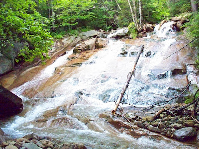
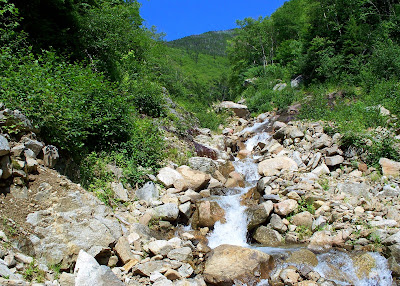
Roadripper, I saw quite a number of waterfalls (or perhaps technically cascades) on my bushwhack up the brook and into the ravine. Photos of two of them are at the end of this response.

Hillwalker, thanks for the insight about the network of old logging drag roads in that area. Sounds like I’ve got some more “ambling” to do in there!;)

Dave, guess I should’ve figured that this would be a little piece of heaven for backcountry skiing. You guys really rock! Wish I had gotten into that sport awhile back when I had a few less years under my belt. But, maybe an old dog can be taught new tricks?!:D

Avk4316, thanks for taking time to respond and share some of your recollections and memories of the area in and around Walker Ravine.
-----------------

As mentioned above in my response to Roadtripper, here are photos of two (of many) cascades seen during my whack up Walker Brook.

100_2412.JPG
100_2545.JPG
 
Last edited:
The fold out map bound in my 1918 (2nd edition) WMG, shows a trail going up Walker Ravine and dead ending.
Wonder if it's like Gulf of Slides where you were then expected to continue up a slide?

Many winters ago, Richard Clark (perhaps 2nd only to Guy Waterman in 4k winter bushwhacks) convinced a group to whack due W down the ridge from Lincoln as all the scrub was buried in hardpack snow. Where the ridge sort of ended we slid down to the brook and picked up a good logging road which made an easy walk back to the parking lot.

Summer explorers of this area may find the body of a missing hiker whose expensive and unsuccessful search years ago led to a previous attempt to require hiking licenses.

Hillwalker - did you ever try to follow the woods road down from where FW leaves it to cross the brook, I'm looking for a safer high-water route?
 
Suprised there is no mention of the trail on the Lost Trails site.
 
More info

Wonder if it's like Gulf of Slides where you were then expected to continue up a slide?

Many winters ago, Richard Clark (perhaps 2nd only to Guy Waterman in 4k winter bushwhacks) convinced a group to whack due W down the ridge from Lincoln as all the scrub was buried in hardpack snow. Where the ridge sort of ended we slid down to the brook and picked up a good logging road which made an easy walk back to the parking lot.

Summer explorers of this area may find the body of a missing hiker whose expensive and unsuccessful search years ago led to a previous attempt to require hiking licenses.

Hillwalker - did you ever try to follow the woods road down from where FW leaves it to cross the brook, I'm looking for a safer high-water route?

Not sure where you mean. But as an aside, the old trail location where it abruptly goes right just above the falls above Cloudland falls and then comes out at the base of Shining Rock used to be navigable. Haven't tried that route for maybe ten years or more. That must have been a huge reroute to construct whenever it was done.
 
But as an aside, the old trail location where it abruptly goes right just above the falls above Cloudland falls and then comes out at the base of Shining Rock used to be navigable. Haven't tried that route for maybe ten years or more. That must have been a huge reroute to construct whenever it was done.
I tried it a couple years ago and got lost, yes the long section on the old road added a lot to the mileage for little elevation gain.

As to my question, going downhill you have the long section on the old road, cross the brook and pick up the road again, then leave it L to drop off and cross brook again. [Call this point #1]. Then after a couple more crossings, you pick up a lower road on the R bank and follow it awhile before again leaving L to cross brook. [Call this point #2] So if you stay on the old road at either point #1 or #2, this will definitely save a couple tricky crossings but is the walking easy enough to be worth it?
 
No idea

I tried it a couple years ago and got lost, yes the long section on the old road added a lot to the mileage for little elevation gain.

As to my question, going downhill you have the long section on the old road, cross the brook and pick up the road again, then leave it L to drop off and cross brook again. [Call this point #1]. Then after a couple more crossings, you pick up a lower road on the R bank and follow it awhile before again leaving L to cross brook. [Call this point #2] So if you stay on the old road at either point #1 or #2, this will definitely save a couple tricky crossings but is the walking easy enough to be worth it?

During my many trips up and down the Falling Waters trail I have often looked at the old road where it stays up higher but since it is somewhat tree clogged, never tried to follow it. It does seem to stay on the north bank when the Falling Waters crosses. Wondered about that the last time I came down about two weeks ago. Could be that washouts took it away in places.
 
Top