
1HappyHiker
Well-known member
There was some hesitancy in posting a Trip Report that is so mild-mannered compared to many reports posted on this Forum. But after mulling it over for a day, I opted to post it, despite my reservations. So here goes!
The snow that fell here in the Bethlehem area on 02-February was the powdery type. To take advantage of the fluffy white stuff, I decided to do a combination XC-ski and snowshoe trek in the Zealand area. This definitely was NOT an epic adventure!
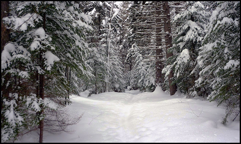
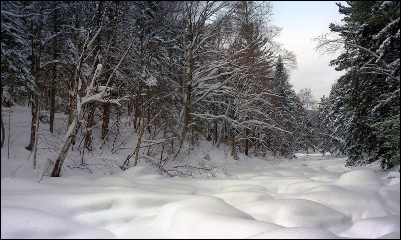
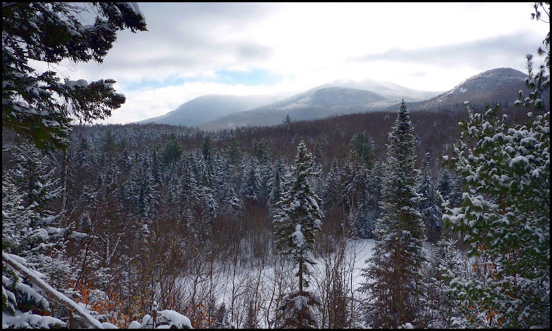
I started my trek by skiing on the very tame Flat Iron XC Ski Trail which takes you through some nice woods, and along the Zealand River. At one point, there is a nice view toward North & South Sugarloaf plus Mt. Hale. Below are a few snapshots from this first phase of my trek.
A Segment of the Flat Iron XC Ski Trail
Frozen/Snow-Covered Zealand River as viewed from Flat Iron XC Ski Trail
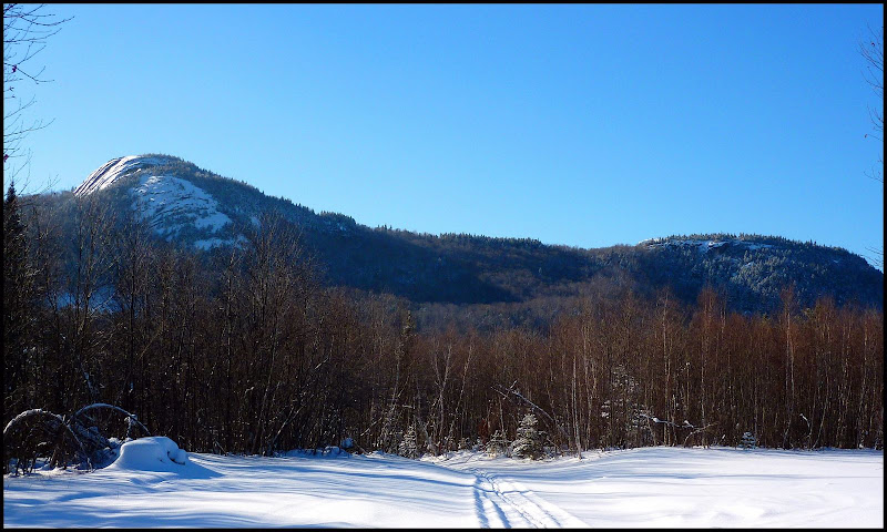
Sugarloafs & Mt. Hale from Flat Iron XC Ski Trail
After skiing the short (about 1.3 miles) Flat Iron XC Ski Trail, I continued on down the Zealand Road for a short distance and then diverged from the road to ski a segment of the Spruce Goose XC Trail. Although the snow on this trail was powdery, it was deep and unbroken. I wasn't having a lot of fun and so I opted to leave this trail behind one of the Sugarloaf Campground spots and headed back to the main road.
And so, the next phase of my trek was to ski the main road to the Wildlife Pond area. When I arrived at this location, there was no evidence that anyone had recently travelled on the trail to this area. Since I couldn't really determine where the trail was, I simply began skiing off-trail in the direction of the pond. As a side-note, I'm really pleased with my Rossignol BC-90 skis for off-trail adventures. I feel that the floatation they provide is at least as good as (and maybe a bit better) my MSR snowshoes.
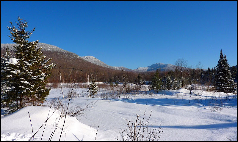
Anyway, below are a few snapshots taken from the Wildlife Pond location and a nearby area.
Rosebrook Range on left + Mt. Tom near the center in the distance
Middle and North Sugarloaf
The final phase of my adventure was to ascend North Sugarloaf. I didn't use the traditional approach via the Sugarloaf Trail off the Zealand Road. Instead, I used a non-traditional approach from the west side of the mountain which involved skiing part of the way, and then snowshoeing the steeper portions.
As a side-note, this off-trail trek was done on public land. And as a side-note to this side-note, Steve Smith recently provided me with an excellent link to a map that can be used to determine boundaries for public and non-public lands. I've found it to be a fantastic resource for plotting off-trail adventures. If you're interested, you can click HERE for the link. Once you're at this website, select "Land Conservation" as your Theme (at the upper right of the screen), and then play around with the map to get some familiarity with how it works.
Anyway, enough side-notes!! Below are a few snapshots from my trek to North Sugarloaf. The first snapshot is a side-by-side photo that shows unbroken snow in open hardwoods with a cobalt-blue sky (does it get any better than this??), and it also shows the results of trail-breaking on a wonderful winter day.

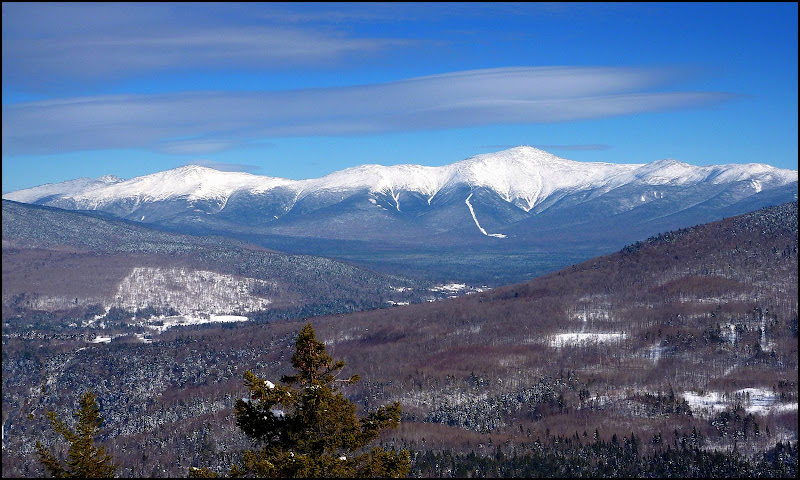
At the top of North Sugarloaf, there are many nice views, but the trophy-view is the Presidential Range!
As indicated at the beginning, this report will have limited appeal, but I opted to post it anyway in case there might be a few folks who get some enjoyment from this type of adventure.
1HappyHiker
The snow that fell here in the Bethlehem area on 02-February was the powdery type. To take advantage of the fluffy white stuff, I decided to do a combination XC-ski and snowshoe trek in the Zealand area. This definitely was NOT an epic adventure!
I started my trek by skiing on the very tame Flat Iron XC Ski Trail which takes you through some nice woods, and along the Zealand River. At one point, there is a nice view toward North & South Sugarloaf plus Mt. Hale. Below are a few snapshots from this first phase of my trek.
A Segment of the Flat Iron XC Ski Trail
Frozen/Snow-Covered Zealand River as viewed from Flat Iron XC Ski Trail
Sugarloafs & Mt. Hale from Flat Iron XC Ski Trail
After skiing the short (about 1.3 miles) Flat Iron XC Ski Trail, I continued on down the Zealand Road for a short distance and then diverged from the road to ski a segment of the Spruce Goose XC Trail. Although the snow on this trail was powdery, it was deep and unbroken. I wasn't having a lot of fun and so I opted to leave this trail behind one of the Sugarloaf Campground spots and headed back to the main road.
And so, the next phase of my trek was to ski the main road to the Wildlife Pond area. When I arrived at this location, there was no evidence that anyone had recently travelled on the trail to this area. Since I couldn't really determine where the trail was, I simply began skiing off-trail in the direction of the pond. As a side-note, I'm really pleased with my Rossignol BC-90 skis for off-trail adventures. I feel that the floatation they provide is at least as good as (and maybe a bit better) my MSR snowshoes.
Anyway, below are a few snapshots taken from the Wildlife Pond location and a nearby area.
Rosebrook Range on left + Mt. Tom near the center in the distance
Middle and North Sugarloaf
The final phase of my adventure was to ascend North Sugarloaf. I didn't use the traditional approach via the Sugarloaf Trail off the Zealand Road. Instead, I used a non-traditional approach from the west side of the mountain which involved skiing part of the way, and then snowshoeing the steeper portions.
As a side-note, this off-trail trek was done on public land. And as a side-note to this side-note, Steve Smith recently provided me with an excellent link to a map that can be used to determine boundaries for public and non-public lands. I've found it to be a fantastic resource for plotting off-trail adventures. If you're interested, you can click HERE for the link. Once you're at this website, select "Land Conservation" as your Theme (at the upper right of the screen), and then play around with the map to get some familiarity with how it works.
Anyway, enough side-notes!! Below are a few snapshots from my trek to North Sugarloaf. The first snapshot is a side-by-side photo that shows unbroken snow in open hardwoods with a cobalt-blue sky (does it get any better than this??
), and it also shows the results of trail-breaking on a wonderful winter day.
At the top of North Sugarloaf, there are many nice views, but the trophy-view is the Presidential Range!
As indicated at the beginning, this report will have limited appeal, but I opted to post it anyway in case there might be a few folks who get some enjoyment from this type of adventure.
1HappyHiker
Last edited: