4000'er
New member
Sorry,
I got side tracked on another project. I will try to set something up this week.
I got side tracked on another project. I will try to set something up this week.

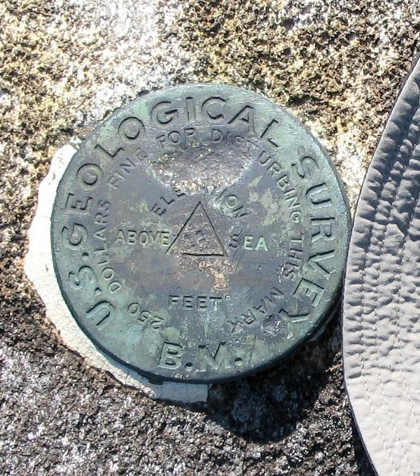
Sometimes.Nate said:Are triangulation stations depicted in any way on USGS maps, or can their locations only be found from their respective datasheets? Also, on Topozone, I've noticed how often there's a triangle near where at "BM" appears on a map, but for the BM's I've tried to locate near my place, I haven't been able to find anything. Do the triangles not accurately depict where the benchmark disks are, did the disks happen to be missing for the three spots I visited, or does not every spot that's noted on the map with a "BM" actually have a benchmark disk planted there? Or it is none of the above?
Incidently, triangulation stations, originally defined by trigonometric triangulation, are now maintained by survey grade GPS by the NGS.NGS is a federal government agency within the National Oceanic Atmospheric Administration (NOAA). NGS is responsible for maintaining the National Spatial Reference System (NSRS) which is the basis for all mapping and surveying in the USA. For more information on NGS visit our webpage, www.ngs.noaa.gov
Geocaching.Com has a snap shot of the NGS database as of 2000 or 2001 (not sure), so marks that have been added more recently are not there. To get data directly from the NGS use this site: http://www.ngs.noaa.gov/cgi-bin/datasheet.prl?Type=DATASHEETSNate said:Should Geocaching.com have a complete list of all major triangulation stations? I ask because two locale stations that are depicted on Topozone (with the coordinates of 42 25.46N 71 7.12W and 42 25.30N 71 7.49W) are not mentioned at all on Geocaching. But other than that, the website does seem to have fairly complete listing.
Geocaching.com is not a real issue since they simply reproduce the NGS data, albeit at a point in time. They are primarily interested in Geocaching and the web owners only tolerate benchmarking but they are not interested in expending new effort to keep the data up to date.Nate said:Not to pick on Geocaching.com or the NGS listing, but in some subsequent poking around I found they they don't have a complete listing of benchmarks and triangulation stations. After all, they don't list the triangulation station that's on New Hampshire's Mount Tremont (which is depicted in Topozone and is readily observable to this day). Further, I stumbled upon a benchmark today, #5 FC, which is located on the sidewalk at about 42 24.84N 71 7.20W (this BM was installed by the Mass. Highway Dept.), and which is not mentioned or depicted anywhere.
But, my nitpicking aside, these two online sources certainly seem adequate enough.
")
PB seems to have skipped this one so I'll try.Nate said:Do the triangles not accurately depict where the benchmark disks are, did the disks happen to be missing for the three spots I visited, or does not every spot that's noted on the map with a "BM" actually have a benchmark disk planted there?
RaymondRaymond said:I don’t have as many as I thought I had either, but here is my entire meager collection (ten photographs).
The third (Catamount Mountain in the Adirondacks) and tenth (Doubletop Mountain in Baxter State Park) are best. Doubletop’s is labeled ‘‘McNair.’’ The two Colvin bolts I’ve photographed, Noonmark and Dix, are kind of small, but you can click on any photo to enlarge it.
I can’t figure out how to have them simply appear here on this page as others have done.


Hi Raymond again.Raymond said:...
Doubletop’s is labeled ‘‘McNair.’’
...
I can’t figure out how to have them simply appear here on this page as others have done.
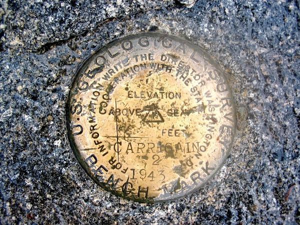
Papa Bear said:Recently, a friend was hiking in Baxter State Park in Maine (home of Katahdin) and climbed Doubletop Mountain, a nice climb about 5 miles west of Katahdin. Among his pictures, there was a shot of a USGS triangulation station stamped "MC NAIR 1929".
I looked it up in the NGS database, searching in the BSP area. Initially I found a survey marker on Horse Mountain, which I had never heard of. I checked where it was and it seems it is a peak overlooking Grand Lake Metagamon, near the road into BSP from the north gate. But it was something like 10 miles from Doubletop. But then I looked further (search for Designation "MCNAIR" in Maine) and found that there are no less than 6 stations in northern Maine, and the datasheet for all of them say "A U.S. GEOLOGICAL SURVEY DISK STAMPED MC NAIR 1929", and all of them are on mountain tops under fire towers, including Horse Mountain, Beetle Mountain, Norway Bluff, Big Spencer, Sobunge Mountain and Deboullie Mountain. And this list must be just part of the story since it didn't include Doubletop (not unusual - many USGS marks are not in the NGS database). Seems like Mr. Mc Nair, whoever he was, was a busy guy in 1929.
NGS guy said:I've checked the original USGS horizontal control records. The survey chief of party was a Mr. E. L. McNair who was responsible for a fairly large network survey during 1929. Unfortunately the USGS data sheets do not indicate what was actually stamped on the disks so we must rely on the later recovery information from USC&GS.
If the URL does not point to an image (.jpg or one of the other types) it won't display. So for example you cannot display a whole web page with the [*img*] directive.Raymond said:Thanks, Papa. It was actually the person who started this thread, 4000'er, who was looking for the photos. I was just offering what I could.
I think I tried doing what you suggested for posting the photos, but I just had a blank spot when I clicked the Preview button. The individual photos on one of my Web pages don't seem to have individual Web addresses, and having just one picture on a page (as I tried with two of those photos) doesn't work either. Maybe it has something to do with them being posted on a .Mac page, I don't know.
 ).
).Enter your email address to join: