
1HappyHiker
Well-known member
Background:
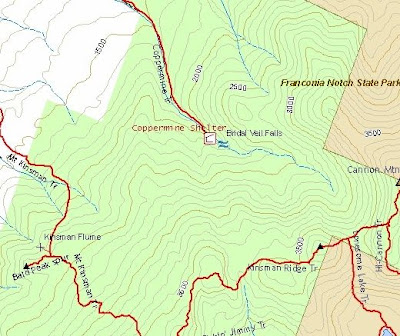
It’s probably just me, but whenever I look at a trail map for the Kinsman-Cannon area, there’s something that has always bugged me! Take a look at the map below and you’ll see that the Coppermine Trail goes directly toward the Kinsman Ridge Trail, but then just STOPS dead at Bridal Veil Falls!!
I’ve often thought of attempting to bushwhack from the end of the Coppermine Trail up to the Kinsman Ridge Trail. And so, when I woke up on the morning of the hike, I decided that this was the day to “color outside the lines” and give it a try. I further decided to make it a loop by continuing on the Kinsman Ridge Trail over the Cannon Balls to connect with the Mount Kinsman Trail and take that trail back down to Rt. 116, and then road walk 0.9 mile back to the Coppermine trailhead.
This trek was somewhat reminiscent of my recent bushwhack to Mt. Davis from the Dry River Trail to the Davis Path. In both this cases, I did a bushwhack where it seemed (at least to me) that there should be a trail!
Funny Story:
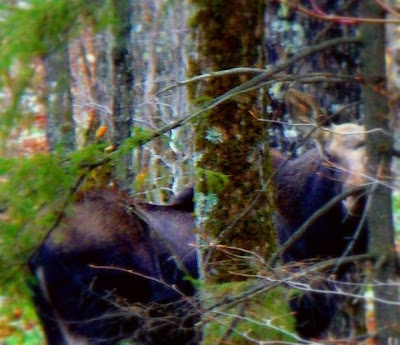
OK, before giving some details about this journey, I’ve got to share a funny story. Probably like most folks, when I bushwhack I spend a lot of time looking down at the ground to make sure that I don’t trip over something, or step in a hole, etc. Today, after looking intently down at the ground for awhile, I raised my head and there I was nearly eyeball–to-eyeball, nose-to-nose with a moose!!
It was sort like one of those awkward moments when you meet someone for the first time and don’t know exactly what to say. So, I decided to break the ice and very softly said to the moose “Hey, how you doin’?” I could tell immediately that this made the moose a bit uneasy, and it very soon began to saunter away from me. But it was looking over its shoulder as if to say, “I don’t know what you are, or what you’re doing here, but this is just way too strange for me! I’m out of here!”
I fumbled around and finally was able to get out my camera and fire off one hurried snapshot just before the moose disappeared into the forest.
The Journey:
Whereas it just as easily could have gone the other way, this entire trek worked out even better than I had imagined it would. The round-trip loop took just about 7.5 hours and that INCLUDED time for a lunch-break, plus taking pictures.
I took the Coppermine Trail nearly all the way to Bridal Veil Falls, but left this trail after crossing the wooden bridge (just a short distance from Bridal Veil Falls). From there I immediately picked up the remnants of the old Coppermine Ski Trail and followed it for a few tenths of a mile. Eventually, I veered off the old ski trail and began to head in a more southerly direction toward the Kinsman Ridge Trail. This is where the true whack began.
After about an hour of whacking I checked my GPS to see how far I was from the Kinsman Ridge Trail. It said 0.16 miles. I thought “nah!” I’ve not worked nearly hard enough or whacked long enough to be that close. But guess what?! The GPS was correct! Within another 10 minutes I was on the Kinsman Ridge Trail, just a few feet east of the junction of the Lonesome Lake Trail.
I should add that the whack portion of this trek was through predominately open woods, was never overly steep, and there were no ledge scrambles, tricky water crossings, etc. And I can truthfully say without any exaggeration, the whack portion of this trek was less intense than some of the stretches along the Kinsman Ridge Trail!!
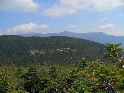
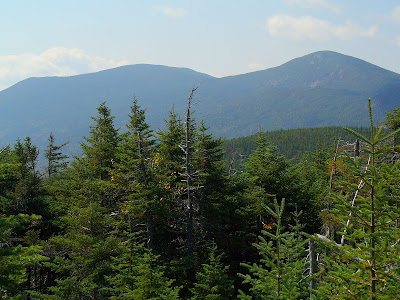
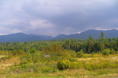
The on-trail portion of the hike also went fine. The trek over the Cannon Balls on the Kinsman Ridge Trail consisted of the well-known PUDs (pointless ups & downs), and traversing over peaks not known for their fine views! However, along the way there are a few mediocre views of the Franconia Range and of the Kinsmans (photos below).
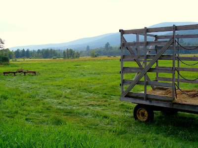
The trek down the Mount Kinsman Trail to Route 116 was a breeze (took just slightly over an hour)! And, the road walk portion went very quickly. There’s even entertainment along the way! You get nice farm views on the west side of the road, and on the east side, there are nice views toward the area that you just hiked (photos below)!!
THE BOTTOM LINE TO ALL THIS: I’m probably not the first one to whack to Coppermine Col from the Bridal Veil Falls area. Nonetheless it was still a unique experience for me and great fun to “color outside the lines” by connecting the Coppermine Trail to the Kinsman Ridge Trail. And, it was great to meet the moose along the way, even if it was put off by my attempt to make friends!
1HappyHiker
It’s probably just me, but whenever I look at a trail map for the Kinsman-Cannon area, there’s something that has always bugged me! Take a look at the map below and you’ll see that the Coppermine Trail goes directly toward the Kinsman Ridge Trail, but then just STOPS dead at Bridal Veil Falls!!
I’ve often thought of attempting to bushwhack from the end of the Coppermine Trail up to the Kinsman Ridge Trail. And so, when I woke up on the morning of the hike, I decided that this was the day to “color outside the lines” and give it a try. I further decided to make it a loop by continuing on the Kinsman Ridge Trail over the Cannon Balls to connect with the Mount Kinsman Trail and take that trail back down to Rt. 116, and then road walk 0.9 mile back to the Coppermine trailhead.
This trek was somewhat reminiscent of my recent bushwhack to Mt. Davis from the Dry River Trail to the Davis Path. In both this cases, I did a bushwhack where it seemed (at least to me) that there should be a trail!
Funny Story:
OK, before giving some details about this journey, I’ve got to share a funny story. Probably like most folks, when I bushwhack I spend a lot of time looking down at the ground to make sure that I don’t trip over something, or step in a hole, etc. Today, after looking intently down at the ground for awhile, I raised my head and there I was nearly eyeball–to-eyeball, nose-to-nose with a moose!!
It was sort like one of those awkward moments when you meet someone for the first time and don’t know exactly what to say. So, I decided to break the ice and very softly said to the moose “Hey, how you doin’?” I could tell immediately that this made the moose a bit uneasy, and it very soon began to saunter away from me. But it was looking over its shoulder as if to say, “I don’t know what you are, or what you’re doing here, but this is just way too strange for me! I’m out of here!”
I fumbled around and finally was able to get out my camera and fire off one hurried snapshot just before the moose disappeared into the forest.
The Journey:
Whereas it just as easily could have gone the other way, this entire trek worked out even better than I had imagined it would. The round-trip loop took just about 7.5 hours and that INCLUDED time for a lunch-break, plus taking pictures.
I took the Coppermine Trail nearly all the way to Bridal Veil Falls, but left this trail after crossing the wooden bridge (just a short distance from Bridal Veil Falls). From there I immediately picked up the remnants of the old Coppermine Ski Trail and followed it for a few tenths of a mile. Eventually, I veered off the old ski trail and began to head in a more southerly direction toward the Kinsman Ridge Trail. This is where the true whack began.
After about an hour of whacking I checked my GPS to see how far I was from the Kinsman Ridge Trail. It said 0.16 miles. I thought “nah!” I’ve not worked nearly hard enough or whacked long enough to be that close. But guess what?! The GPS was correct! Within another 10 minutes I was on the Kinsman Ridge Trail, just a few feet east of the junction of the Lonesome Lake Trail.
I should add that the whack portion of this trek was through predominately open woods, was never overly steep, and there were no ledge scrambles, tricky water crossings, etc. And I can truthfully say without any exaggeration, the whack portion of this trek was less intense than some of the stretches along the Kinsman Ridge Trail!!
The on-trail portion of the hike also went fine. The trek over the Cannon Balls on the Kinsman Ridge Trail consisted of the well-known PUDs (pointless ups & downs), and traversing over peaks not known for their fine views! However, along the way there are a few mediocre views of the Franconia Range and of the Kinsmans (photos below).
The trek down the Mount Kinsman Trail to Route 116 was a breeze (took just slightly over an hour)! And, the road walk portion went very quickly. There’s even entertainment along the way! You get nice farm views on the west side of the road, and on the east side, there are nice views toward the area that you just hiked (photos below)!!
THE BOTTOM LINE TO ALL THIS: I’m probably not the first one to whack to Coppermine Col from the Bridal Veil Falls area. Nonetheless it was still a unique experience for me and great fun to “color outside the lines” by connecting the Coppermine Trail to the Kinsman Ridge Trail. And, it was great to meet the moose along the way, even if it was put off by my attempt to make friends!
1HappyHiker
Last edited:
")