Garfield

vftt.org

Help Support vftt.org:

This site may earn a commission from merchant affiliate links, including eBay, Amazon, and others.

SherpaTom

Member
Joined
Oct 6, 2003
Messages
178
Reaction score
4
Location
Bellingham, Ma
Looking for advice.

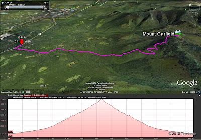
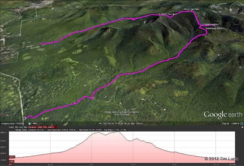
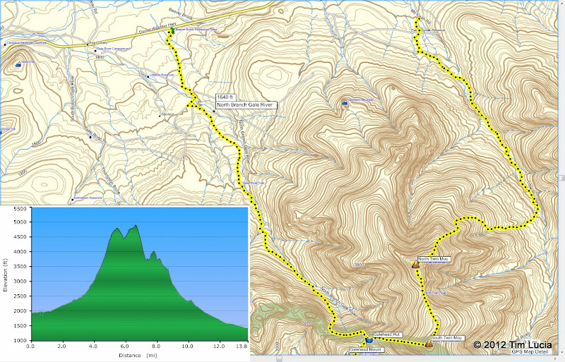
As I understand it we can reach the Garfield trailhead either from parking on 4 Corners or Galehead off of Rt3. I understand the latter to have better parking. Does anyone know what the road distance to the trailhead is from each parking area?
 
Some years (low snow) the entrance before the gate at the south end (Garfield end) is plowed enough to park several cars. If that is not an option (and I've seen many parked there this year already), then the next shortest route is from 5 corners to walk the road. It's a about 3/10th of a mile.

route.jpg


See also here: http://caltopo.com/map?id=3B34

Tim
 
Last edited:
Yes you should park at the southern Gale River Loop Road spot and then it is 1.2 miles to the beginning of the Garfield Trail...couple years ago I tried to keep up with my 6'4" nephew and we made it in just about 20 minutes......
 
I will be going out to garfields knee (the cliff on garfield you can see from lafayette ) anyone can join me.
 
The better parking you might be referring to is for Galehead which is at the Beaver Brook X-C ski pull-out.
 
The better parking you might be referring to is for Galehead which is at the Beaver Brook X-C ski pull-out.

Is there a trail/bushwhack that leads from the Beaver Brook parking area on Rte 3 to access the Gale River Trail for Galehead and the Twins? Looks like it gets plowed and has outhouses year round. Is it used often (i.e is it easy to follow in winter)? Not familiar with the route and I don't normally like to take a route in winter that I haven't done in the summer. The reliable parking and bathroom is a big plus this time of year though. Better or worse than doing the road walk? Looks on map like it would be shorter as well but may have river crossings/water.

Thoughts?

There is a well-defined trail. If you Google for "Galehead winter route" you might turn up one of the numerous trip reports that include a gps track or map.
 
If I remember correctly, take the trail that is at the far right, it loops around to the back not far from the interection where the road goes to the Little River trailhead.
 
At the end of the trail, turn right on the road. Just after the left turn, go into the campsite on the right (#3), and then take the ski trail at the back of the site. When it doubt, stay left, and you will arrive at Beaver Brook.

Google%2520Earth.jpg

Garmin.jpg


Tim
 
In case it's not obvious, Tim's directions are how to exit from the Gale River Trail summer trailhead to Beaver Brook XC parking. The Little River Rd parking area is the winter location for access to the North Twin Trail (since Haystack Rd is closed).

To get from Beaver Brook to the Gale River Trail, you follow the XC trail into the woods, and stay to the right, eventually coming out at Campsite #3, etc.

To do Galehead + Twins loop via these 2 parking areas probably warrants a car spot, since that's a lot of road walk. If you want to do a loop w/slightly less road walk, take Haystack Rd out to Rt 3 rather than Little River Rd. It's still a long way, but I've seen people doing it.
 
Based on the routes everyone has posted I'll probably have to do this in two hikes. Car spotting is not an option for me and the 19+ miles over this terrain is probably beyond my conditioning right now. Also, aren't the river crossings a big problem on the North Twin Trail? Is there a winter bushwhack of these along the west bank of the river or do you still have to make the 3rd crossing and use the summer bushwhack to avoid the first two? Last thing I want to do after 15-16 miles of walking is fall into the river 5 miles from my car. That's why I figured going out and back on Gale River Trail made more sense.

Also, does anyone have the length of the Beaver X-C short cut? If I am doing the math in AMC Guide correctly it is a 1.6 mile road walk from five corners to the Gale River trail head. Is the Beaver X-C short cut that much shorter and or better graded to make the effort worth it?
 
Most people go up the Twins first in case the river is a problem. I think only red liners do the first two crossings. In my experience the third one has always been crossable except in extreme flow conditions.

My GPS track says 13.8 miles and 3900 feet.

Tim
p.s. I have plans to hit those three again soon... might not be until February. You are welcome to join or we can help with car spotting if you wish to solo.
 
My GPS track says 13.8 miles and 3900 feet.

Tim
p.s. I have plans to hit those three again soon... might not be until February. You are welcome to join or we can help with car spotting if you wish to solo.

My rough tallies included the road walks (If AMC Guide was right I think it was 1.6 miles and 2.5 miles - not counting Rte 3 if I did it as a giant loop).

Thanks for the offer on the car spot. However my holiday "conditioning" program was a huge success so I'll probably still split and do Twins first considering there will be 2.5 miles each way of just road walk not even counting the actual hike (which I think was 11.2 miles back and forth). May just do North Twin and then try Galehead and South Twin another day. Have to see how much of a toll the road walk takes on me.

Does that crossing ever bridge over at any point later in the winter or is it too wide? I did this trail last 5/12/12 on an "average" flow day and the crossing was pretty tricky from what I remember. Can the USGS flow data site be reliably used as a guide in winter too or does that get skewed with ice, etc? I use regularly in the shoulder and summer seasons and it is a very helpful guide.
 
There was also a very large tree that had fallen down across the river (at the 3rd crossing) that was pretty easy to walk across. Not sure if it's still intact, but I imagine it will be there for many years to come, barring a huge flood. That might actually be it in the background of Tim's photo.
 
Last edited:
The better parking you might be referring to is for Galehead which is at the Beaver Brook X-C ski pull-out.
Note that this area is closed from 10 pm - 6 am or somesuch which presumably makes overnight parking illegal
 
Top