
The Feathered Hat
Active member
Total miles: 17
Time: 9 hours
A couple of reasons compelled Tuckerman and me to stretch a climb to Tecumseh's summit into a long, all-day walk. One, we're trying to get into leg-shape for three long hikes we'd like to complete before summer's end (the Owl's Head death march, and traverses of the Bonds and Franconia Ridge). Two, last weekend's experience on Isolation and in the Dry River Wilderness, where we met 21 people on the trail to the peak but no one at all in the Wilderness, encourages us to avoid the major peaks and spend our time exploring lesser-known routes and trails, at least on summer weekends when the weather's nice. We have nothing against other hikers, of course, who we enjoy meeting on the trail (especially Tuck; every new hiker is a new excuse for a puppy to go crazy with excitement), but we like hiking best in the peace and quiet, and we also have a fondness for under-used, even obscure and lost, paths. Not to mention: we are also still learning how to control Tuckerman's habit of jumping up on hikers he doesn't even know. Some people just aren't wild about getting a kiss from a 50-pound pup. (He's on a leash sometimes but not all the time; kisses sometimes happen.)
So to the normal Tecumseh hike via the Mt. Tecumseh Trail we attached a hike on the length of the East Pond Trail from the Kancamagus Highway. Out and back, this adds about 11 miles to the 6.2-mile out and back up Tecumseh from the western side, and adds some elevation too, as the East Pond Trail climbs 1,300 feet on each side to a saddle on Scar Ridge. The total elevation gain becomes 4,800 feet by this route, for a total elevation change of 9,600, not counting the 100-foot drop the trail makes between Tecumseh's eastern knob and the mountain's true summit. Hiking this long but beautiful route, Tecumseh does not feel like a minor peak.
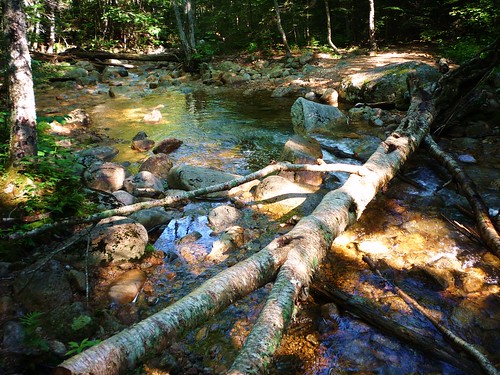
About a half-mile from the East Pond trailhead on the Kanc, the trail crosses Pine Brook, and we found that this log makes an excellent bridge over the water (though, with less rain this past week, it is no longer a bridge over troubled water, at least for the time being):
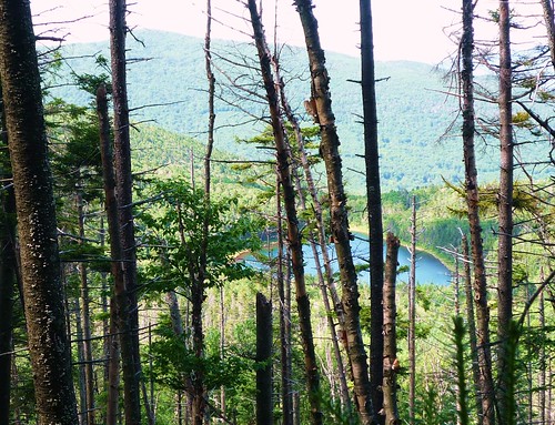
From just below the saddle across Scar Ridge, we got our first view of two of our day's landmarks, East Pond and the western shoulder of Mt. Tecumseh:
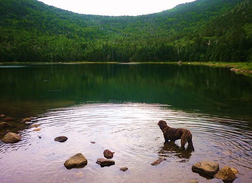
East Pond is a lovely, quiet, peaceful pool at the 2,500-foot elevation; the Scar Ridge saddle that the East Pond Trail crosses can be seen directly above the pond:
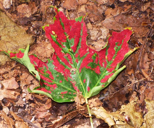
We trudged on, meeting a couple of people between East Pond and the trailhead on Tripoli Road. (In all, we met just five people on this trail the whole day, and all of them were on the section between the pond and Tripoli Road. Tuck and I had the best section of the East Pond Trail, from the Kanc to the pond, all to ourselves.) After we reached the trailhead we walked up Tripoli Road less than half a mile to the western trailhead for the Mt. Tecumseh Trail and began our climb of the mountain, first through gorgeous hardwood forest, where we saw this colorful maple leaf tinged with red fungus:
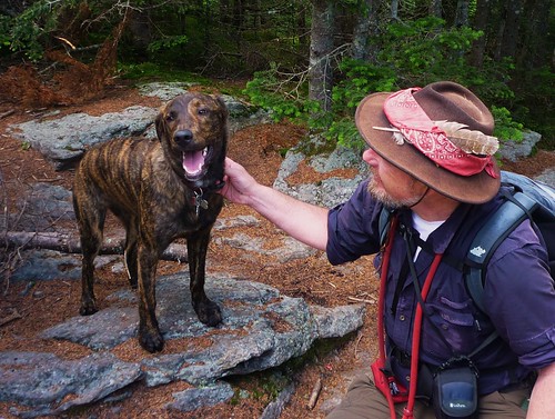
The Mt. Tecumseh Trail, like the East Pond Trail, is generally in very good shape. There are some muddy spots, but nothing boot-suckingly deep. However, this route is deceivingly strenuous. It would never be counted among the steepest trails in the Whites, yet its relentless 800-elevation-feet-to-the-mile climb over three miles, plus the heartbreak of losing 100 feet, only to have to gain those feet again, in the saddle between the western and eastern knobs, not to mention a handful of steep, rocky pitches, will suck the energy right out of you on a muggy day. So we didn't rush. And we were meeting quite a few folks on the Mt. Tecumseh Trail, 15 in all, not counting a crowd of eight at the peak. But one of those friendly summit folks took this picture of Tuckerman and the old man when we finally got to the top -- the pup seems pretty pleased with himself for bagging his eighth of the NH48 before he's even 10 months old:
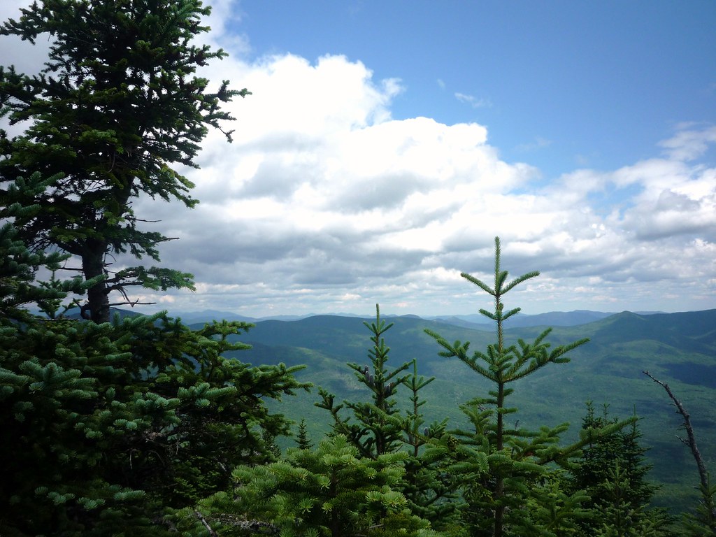
The last time I was on Tecumseh the weather was gray and rainy. So yesterday provided my first look at the fine view from the outlook near the summit:
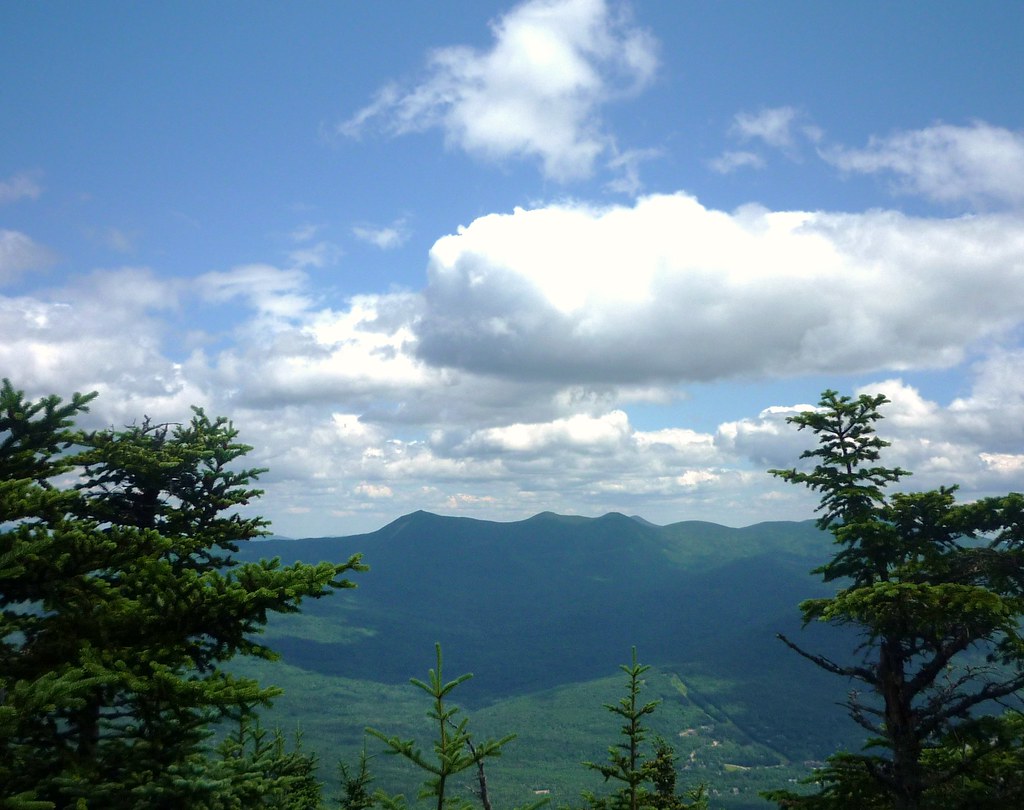
Just to the south, a nice view of the Tripyramids :
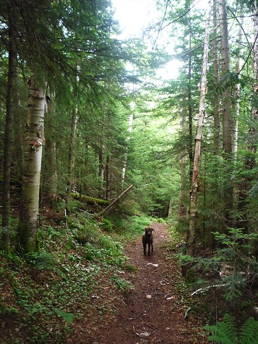
After some lunch and a little chit-chat with our fellow peak-occupiers, we reversed course for the long walk back to the Kanc. Even Tuckerman was beginning to flag after we made the last climb of the day over the Scar Ridge saddle -- here he is on the East Pond Trail just over the other side of the height-of-land:
But a great day. The East Pond Trail, especially the section from the Kanc to the pond, is quite wonderful, not to mention quiet. Most people seem to hike to the pond from the Tripoli Road side (it's a third of the distance, with 500 feet less elevation gain too), but the beautiful grade of the northern side of the trail and its mostly carpet-smooth footing (there's only one rocky, rooty section) will, I hope, draw you to the longer side's charms. They are abundant.
More photos:
http://www.flickr.com/photos/99682097@N00/sets/72157621609281087/
Steve B
The Feathered Hat
[email protected]
___________________________________________
Tuckerman's report for dogs:
Frogs! Sniffed at lots of these bizarre creatures.
Sticks! This is a very good hike for sticks, and I was in a stick mood all day.
Stuff! I found an old ace bandage, Kleenex and -- best of all -- some toilet paper. I'm so happy sloppy hikers leave this stuff in the woods for me to find.
Not enough mud for my taste, but oh well. At least there was less cussing from Big Boss Man.
Two stream crossings (each crossed twice) plus a pond swim -- felt good on a pantingly-warm day.
No hard rock scrambles. Whew!
Except for a stream right at the trailhead, there's no water from the Mt. Tecumseh trailhead to the summit and back again, so tell your Big Boss Person to carry extra.
***.* Three-and-a-half sniffs (out of four). T-Dog says check it out.
Time: 9 hours
A couple of reasons compelled Tuckerman and me to stretch a climb to Tecumseh's summit into a long, all-day walk. One, we're trying to get into leg-shape for three long hikes we'd like to complete before summer's end (the Owl's Head death march, and traverses of the Bonds and Franconia Ridge). Two, last weekend's experience on Isolation and in the Dry River Wilderness, where we met 21 people on the trail to the peak but no one at all in the Wilderness, encourages us to avoid the major peaks and spend our time exploring lesser-known routes and trails, at least on summer weekends when the weather's nice. We have nothing against other hikers, of course, who we enjoy meeting on the trail (especially Tuck; every new hiker is a new excuse for a puppy to go crazy with excitement), but we like hiking best in the peace and quiet, and we also have a fondness for under-used, even obscure and lost, paths. Not to mention: we are also still learning how to control Tuckerman's habit of jumping up on hikers he doesn't even know. Some people just aren't wild about getting a kiss from a 50-pound pup. (He's on a leash sometimes but not all the time; kisses sometimes happen.)
So to the normal Tecumseh hike via the Mt. Tecumseh Trail we attached a hike on the length of the East Pond Trail from the Kancamagus Highway. Out and back, this adds about 11 miles to the 6.2-mile out and back up Tecumseh from the western side, and adds some elevation too, as the East Pond Trail climbs 1,300 feet on each side to a saddle on Scar Ridge. The total elevation gain becomes 4,800 feet by this route, for a total elevation change of 9,600, not counting the 100-foot drop the trail makes between Tecumseh's eastern knob and the mountain's true summit. Hiking this long but beautiful route, Tecumseh does not feel like a minor peak.
About a half-mile from the East Pond trailhead on the Kanc, the trail crosses Pine Brook, and we found that this log makes an excellent bridge over the water (though, with less rain this past week, it is no longer a bridge over troubled water, at least for the time being):
From just below the saddle across Scar Ridge, we got our first view of two of our day's landmarks, East Pond and the western shoulder of Mt. Tecumseh:
East Pond is a lovely, quiet, peaceful pool at the 2,500-foot elevation; the Scar Ridge saddle that the East Pond Trail crosses can be seen directly above the pond:
We trudged on, meeting a couple of people between East Pond and the trailhead on Tripoli Road. (In all, we met just five people on this trail the whole day, and all of them were on the section between the pond and Tripoli Road. Tuck and I had the best section of the East Pond Trail, from the Kanc to the pond, all to ourselves.) After we reached the trailhead we walked up Tripoli Road less than half a mile to the western trailhead for the Mt. Tecumseh Trail and began our climb of the mountain, first through gorgeous hardwood forest, where we saw this colorful maple leaf tinged with red fungus:
The Mt. Tecumseh Trail, like the East Pond Trail, is generally in very good shape. There are some muddy spots, but nothing boot-suckingly deep. However, this route is deceivingly strenuous. It would never be counted among the steepest trails in the Whites, yet its relentless 800-elevation-feet-to-the-mile climb over three miles, plus the heartbreak of losing 100 feet, only to have to gain those feet again, in the saddle between the western and eastern knobs, not to mention a handful of steep, rocky pitches, will suck the energy right out of you on a muggy day. So we didn't rush. And we were meeting quite a few folks on the Mt. Tecumseh Trail, 15 in all, not counting a crowd of eight at the peak. But one of those friendly summit folks took this picture of Tuckerman and the old man when we finally got to the top -- the pup seems pretty pleased with himself for bagging his eighth of the NH48 before he's even 10 months old:
The last time I was on Tecumseh the weather was gray and rainy. So yesterday provided my first look at the fine view from the outlook near the summit:
Just to the south, a nice view of the Tripyramids :
After some lunch and a little chit-chat with our fellow peak-occupiers, we reversed course for the long walk back to the Kanc. Even Tuckerman was beginning to flag after we made the last climb of the day over the Scar Ridge saddle -- here he is on the East Pond Trail just over the other side of the height-of-land:
But a great day. The East Pond Trail, especially the section from the Kanc to the pond, is quite wonderful, not to mention quiet. Most people seem to hike to the pond from the Tripoli Road side (it's a third of the distance, with 500 feet less elevation gain too), but the beautiful grade of the northern side of the trail and its mostly carpet-smooth footing (there's only one rocky, rooty section) will, I hope, draw you to the longer side's charms. They are abundant.
More photos:
http://www.flickr.com/photos/99682097@N00/sets/72157621609281087/
Steve B
The Feathered Hat
[email protected]
___________________________________________
Tuckerman's report for dogs:
Frogs! Sniffed at lots of these bizarre creatures.
Sticks! This is a very good hike for sticks, and I was in a stick mood all day.
Stuff! I found an old ace bandage, Kleenex and -- best of all -- some toilet paper. I'm so happy sloppy hikers leave this stuff in the woods for me to find.
Not enough mud for my taste, but oh well. At least there was less cussing from Big Boss Man.
Two stream crossings (each crossed twice) plus a pond swim -- felt good on a pantingly-warm day.
No hard rock scrambles. Whew!
Except for a stream right at the trailhead, there's no water from the Mt. Tecumseh trailhead to the summit and back again, so tell your Big Boss Person to carry extra.
***.* Three-and-a-half sniffs (out of four). T-Dog says check it out.
Last edited:
")