
The Feathered Hat
Active member
A family event over the long Labor Day weekend prevented Tuckerman and me from taking a major hike (just as well; crowded trails don't attract me), but on Monday we were able to stretch our legs on the Jericho Road Trail up to Cooley Hill, just south of Easton, NH. The climb is gentle and the mileage undaunting; with not a great deal of effort the 1,250-foot elevation gain, 6.5-mile out-and-back hike can be covered in 2.5-3 hours. Yet over those miles the trail, which is often padded with leaves and pine needles, transits through a beautiful hardwood-conifer forest, one of the nicest to be found in WMNF (this will be a spectacular hike in autumn at Height of Color), and just below the summit of the Hill there's a spot that offers a lovely, not-often-seen view of Kinsman Ridge. This is a favorite after-work hike for Tuck and me, and we take it at least once a month.
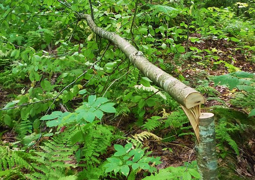
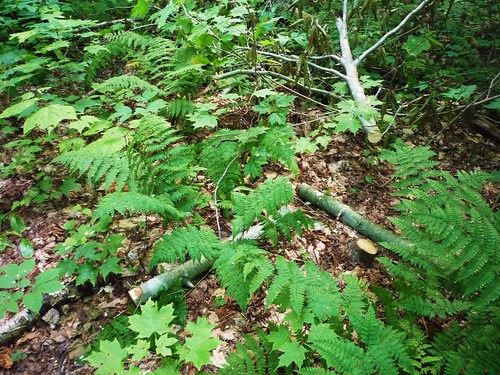
Back in June we came across a handful of small blowdowns in a short span of trail about two miles from the trailhead, and in July we cleared them all. Then in August we found new blowdowns in the same area. As we negotiated the last of them I realized something wasn't right. Not only had we seen no other blowdowns anywhere else on the trail up to that point, there was no evidence of blowdowns off-trail in the forest. I began to examine these new blowdowns more closely and quickly made a disheartening discovery: these weren't blowdowns at all. Someone had deliberately cut these trees and placed them across the trail. Tuck and I walked on, and in a half-mile we came to a spot where four or five large trees crossed the trail at head-height.
The next day I called the local ranger station for that part of the WMNF, in Holderness, and soon received a return call from the ranger who handles law enforcement. We agreed that this was a real mystery; who would want to block access to a trail on public land and for what reason? Not only that, but in all the times Tuckerman and I have hiked the Jericho Road Trail we've never seen anyone -- it's one of the quietest trails in the Whites. If someone was worried about hikers on this trail bushwhacking off-trail into private property, such a worry wouldn't seem to have much merit based on the evidence.
Here's a photo of one of the smaller of the deliberately cut trees:
And another:
The ranger told me he'd send a trail crew out to take a look. What was odd, he said, is that a crew had worked on the trail just a couple of weeks before and hadn't noticed any blowdowns, deliberately cut or not. I told him about clearing the older blowdowns a month earlier, adding that it never occurred to me that they might've been deliberately cut so I didn't check. But since the older blowdowns were in the same place on the trail is the new ones, there's a good chance they were cut too.
I'm happy to report that not only did the trail crew clear out all the new cut-downs that crossed the trail, including the big ones, they also climbed further up the trail to clear away a very large (and legitimate) blowdown that had forced herd-pathing to get around. On Monday, Tuckerman and I happily walked a completely blowdown- and cut-down-free trail.
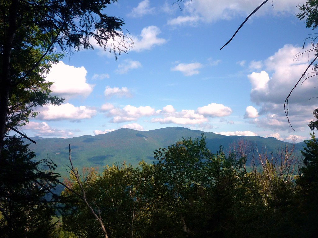
Just below the summit of Cooley Hill (where you'll find the remains of an old fire tower), we took the short unmarked but easily found spur path to the viewpoint that offers a fine scene of the two Kinsmans, North and South:
So... all's well that ends well, I guess. The identity of the Jericho Road Trail vandal remains a mystery, as do his/her motives, but for now the trail is clear and in excellent shape. I called the ranger back and thanked him and the crew for their fine work.
Steve B
The Feathered Hat
[email protected]
_________________________________________
Tuckerman's Report for Dogs:
Chipmunks to chase! Grouse to flush! Toads! Sticks!
Just one spot for good water, a tiny stream that crosses the trail about a mile from the trailhead, so tell your Big Boss Person to carry extra.
No mud. I really, really want it to rain soon, don't you?
*** Three sniffs (out of four). T-Dawg says check it out.
Back in June we came across a handful of small blowdowns in a short span of trail about two miles from the trailhead, and in July we cleared them all. Then in August we found new blowdowns in the same area. As we negotiated the last of them I realized something wasn't right. Not only had we seen no other blowdowns anywhere else on the trail up to that point, there was no evidence of blowdowns off-trail in the forest. I began to examine these new blowdowns more closely and quickly made a disheartening discovery: these weren't blowdowns at all. Someone had deliberately cut these trees and placed them across the trail. Tuck and I walked on, and in a half-mile we came to a spot where four or five large trees crossed the trail at head-height.
The next day I called the local ranger station for that part of the WMNF, in Holderness, and soon received a return call from the ranger who handles law enforcement. We agreed that this was a real mystery; who would want to block access to a trail on public land and for what reason? Not only that, but in all the times Tuckerman and I have hiked the Jericho Road Trail we've never seen anyone -- it's one of the quietest trails in the Whites. If someone was worried about hikers on this trail bushwhacking off-trail into private property, such a worry wouldn't seem to have much merit based on the evidence.
Here's a photo of one of the smaller of the deliberately cut trees:
And another:
The ranger told me he'd send a trail crew out to take a look. What was odd, he said, is that a crew had worked on the trail just a couple of weeks before and hadn't noticed any blowdowns, deliberately cut or not. I told him about clearing the older blowdowns a month earlier, adding that it never occurred to me that they might've been deliberately cut so I didn't check. But since the older blowdowns were in the same place on the trail is the new ones, there's a good chance they were cut too.
I'm happy to report that not only did the trail crew clear out all the new cut-downs that crossed the trail, including the big ones, they also climbed further up the trail to clear away a very large (and legitimate) blowdown that had forced herd-pathing to get around. On Monday, Tuckerman and I happily walked a completely blowdown- and cut-down-free trail.
Just below the summit of Cooley Hill (where you'll find the remains of an old fire tower), we took the short unmarked but easily found spur path to the viewpoint that offers a fine scene of the two Kinsmans, North and South:
So... all's well that ends well, I guess. The identity of the Jericho Road Trail vandal remains a mystery, as do his/her motives, but for now the trail is clear and in excellent shape. I called the ranger back and thanked him and the crew for their fine work.
Steve B
The Feathered Hat
[email protected]
_________________________________________
Tuckerman's Report for Dogs:
Chipmunks to chase! Grouse to flush! Toads! Sticks!
Just one spot for good water, a tiny stream that crosses the trail about a mile from the trailhead, so tell your Big Boss Person to carry extra.
No mud. I really, really want it to rain soon, don't you?
*** Three sniffs (out of four). T-Dawg says check it out.
Last edited: