
IQuest
New member
In the early 2000s after finishing the NH4Ks, I kept hiking by chipping away at the big list that I had at home in my "hiking" folder. This was the NE100 list that was incuded with the half dozen pages that the Four Thousand Footer Committee would mail to you. I didn't know of any internet forums, Google Earth, or that much about hiking really. In 2003 I found my self planning a hike up Mt Carrigain so a friend could check it off but on the map I saw that Vose Spur was just over a mile away and it was a NE100 peak. Our plan was Signal Ridge Tr to Mt Carrigain, then whack straight over to Vose Spur by skirting the top the eastern bowl, and then whack from Vose Spur to the height of land in Carrigain Notch. This route turned into a tough day sidehilling some evil terrain then descending from a viewless summit off of the edge of the world between steep ledges. :twisted: At least we found the talus field in the Carrigain-Vose Spur col but I planned on never returning. I got my check mark so why would I ever want to go back to a trailess and viewless summit. :roll:
Well........Back in September after the FOT48 hike, maddmattd told me that he and Pam were talking about hiking Vose Spur for their NE100 and had thought of adding Carrigain as well and Marlie and I were welcome to join. November 9th came up as the date and since it was a fit for me I joined without a second thought. After I committed though I did have to ask myself why. I guess I like the challenge and with good company, why not?
We met at the Signal Ridge TH just after 8am and had boots on trail by 8:20. There were 7 humans and one dog in our group, including Randy (Matt correct me if I'm wrong) who was climbing Vose Spur for #100.
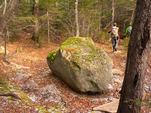
We headed up Signal Ridge Tr, turned right on Carrigain Notch Tr, and after passing the "big rock" found a suitable spot and began to whack. It was 10am. There was no definate herd path at first so we followed a drainage up, skirted some small ledges, and worked our way west to gain the SE ridge. There we found an obvoius herd path which weaved our way upward. It was fairly easy to follow and soon brought us to the bottom of the upper (further away)talus field that can be seen from Signal Ridge.
Big Rock
Talus Field
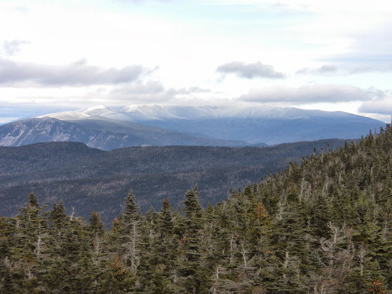
Excellent Views
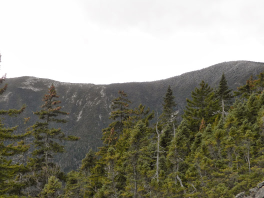
Signal Ridge
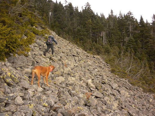
As we climbed the talud field we worked our way over to the right (north) and made our way to the top where the herd path continued into the trees at the upper left corner. After climbing steeply we lost the path near some blowdowns and young spruce so we continued upward. We were only .1 mi fom the summit so we were plenty motivated. Just south of the summt we found another herd path which we were able to follow to the summit, although once I saw the camp chair through the trees I headed straight for it. It was just after 11:30pm when we reached the cannister.
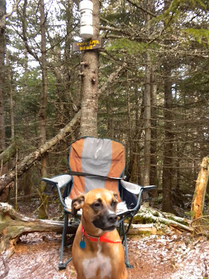
The summit was a little more beat down that what I remembered and there definately wasn't a chair there before. I congratulated Randy and the others soon arrived and began the celebration which included cookies, olives, cheese, and a toast of wine. Thank you Pam. Randy had to beat the top off of the canister with a rock as it was frosted shut. We took out the log book to sign and Matt noticed that some of the first entries were from Salty, Brian, and Greg. :shock: After about 45 minutes the cool weather was starting to become more noticeable and the group discussed their options. As it turned out, for varoius reasons, it would be just Matt, myself, and Marlie heading over to Carrigain while the others returned the way we came.
After leaving the summit we followed the "summit herd path" as far as we could and soon wecould see the the talus field in the Vose Spur-Carrigain col which was our next goal. After that we would try to climb to the top of the NE shoulder of Mt Carrigain and gain the ridgecrest.
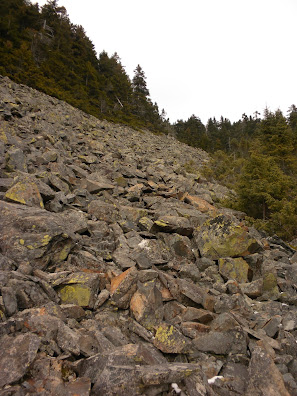
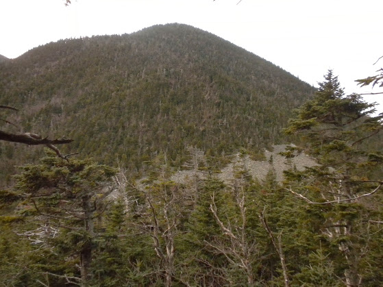
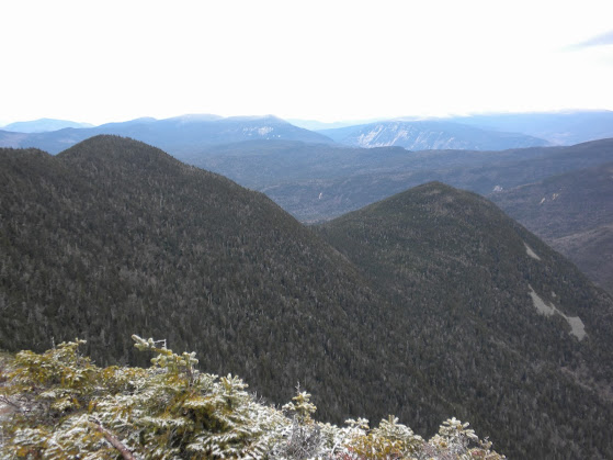
Talus Field in col and NE Shoulder.
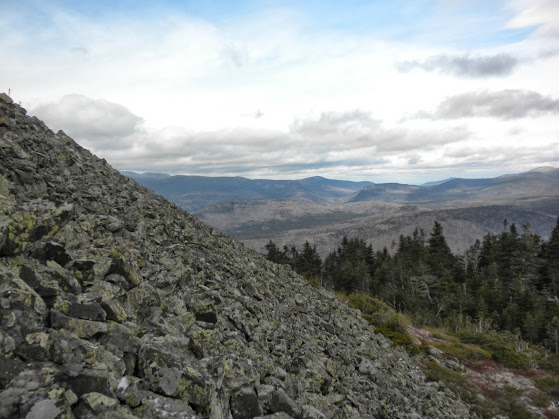
The views from this talus field, particularly north towards the presis were fantastic.
We then climbed up the rocks looking for the best entry point back into the trees without much luck. We didn't really scout for too long so I just found what I thought may have been the highest point and plunged in. The next 1/4 mile was probably the toughest part of the hike. The terrain went up very steeply and was quite thick in spots. So thick infack that I was about 20 feet above Matt and we couldn't see each other. Although it didn't seem like any large patches, there were enough blowdowns and young spruce in the area to make the going very slow. At times I was using a breast stroke to make forward progress. When it became too thick we skirted to the east until a line could be found to head upward and gain elevation. I must say that Marlie did quite well navigating the trees especially since there were times that I had to climb over and walk on the downed trees. As with all mountains, it can't go up forever and we eventually made it to the top of the shoulder where we found a cairne.
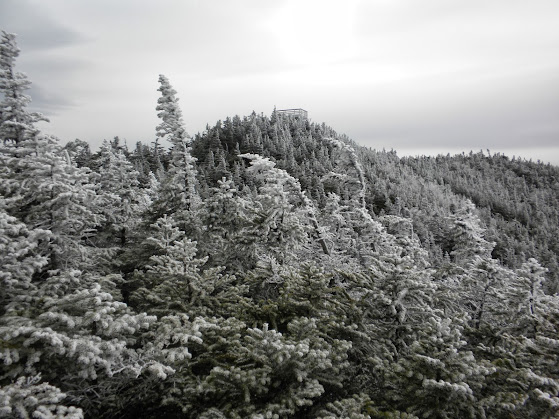
Matt mentioned that he had heard that there used to be a jar here so we looked around breifly but found nothing, More important, the woods opened up a little along the ridgecrest and we discovered a faint, intermittent herd path which basically led us all the way to the summit of Mt Carrigain. This path was not the easiest to follow but by looking for broken branches and following Marlie's lead we were successful at following it for probably 90% of the way. At one point we caught a glimpse of the towere and we knew were were on the home stretch.
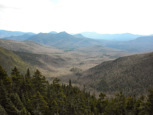
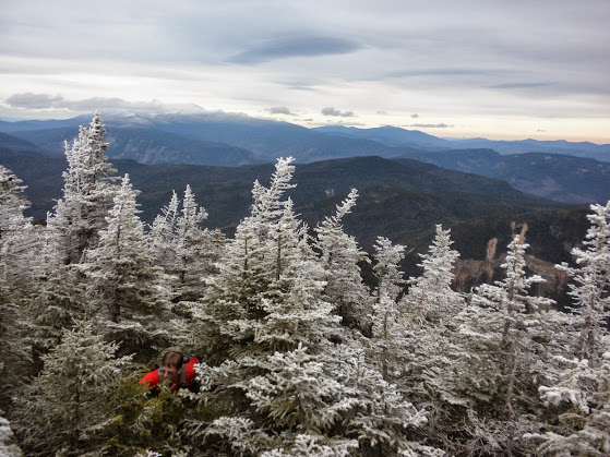
Just before reaching the summit clearing we passed thought a nice patch of alpine scrub which gave us more spectacuar views.
The Home Sretch
Matt Making the Final Push
Well........Back in September after the FOT48 hike, maddmattd told me that he and Pam were talking about hiking Vose Spur for their NE100 and had thought of adding Carrigain as well and Marlie and I were welcome to join. November 9th came up as the date and since it was a fit for me I joined without a second thought. After I committed though I did have to ask myself why. I guess I like the challenge and with good company, why not?
We met at the Signal Ridge TH just after 8am and had boots on trail by 8:20. There were 7 humans and one dog in our group, including Randy (Matt correct me if I'm wrong) who was climbing Vose Spur for #100.
We headed up Signal Ridge Tr, turned right on Carrigain Notch Tr, and after passing the "big rock" found a suitable spot and began to whack. It was 10am. There was no definate herd path at first so we followed a drainage up, skirted some small ledges, and worked our way west to gain the SE ridge. There we found an obvoius herd path which weaved our way upward. It was fairly easy to follow and soon brought us to the bottom of the upper (further away)talus field that can be seen from Signal Ridge.
Big Rock
Talus Field
Excellent Views
Signal Ridge
As we climbed the talud field we worked our way over to the right (north) and made our way to the top where the herd path continued into the trees at the upper left corner. After climbing steeply we lost the path near some blowdowns and young spruce so we continued upward. We were only .1 mi fom the summit so we were plenty motivated. Just south of the summt we found another herd path which we were able to follow to the summit, although once I saw the camp chair through the trees I headed straight for it. It was just after 11:30pm when we reached the cannister.
The summit was a little more beat down that what I remembered and there definately wasn't a chair there before. I congratulated Randy and the others soon arrived and began the celebration which included cookies, olives, cheese, and a toast of wine. Thank you Pam. Randy had to beat the top off of the canister with a rock as it was frosted shut. We took out the log book to sign and Matt noticed that some of the first entries were from Salty, Brian, and Greg. :shock: After about 45 minutes the cool weather was starting to become more noticeable and the group discussed their options. As it turned out, for varoius reasons, it would be just Matt, myself, and Marlie heading over to Carrigain while the others returned the way we came.
After leaving the summit we followed the "summit herd path" as far as we could and soon wecould see the the talus field in the Vose Spur-Carrigain col which was our next goal. After that we would try to climb to the top of the NE shoulder of Mt Carrigain and gain the ridgecrest.
Talus Field in col and NE Shoulder.
The views from this talus field, particularly north towards the presis were fantastic.
We then climbed up the rocks looking for the best entry point back into the trees without much luck. We didn't really scout for too long so I just found what I thought may have been the highest point and plunged in. The next 1/4 mile was probably the toughest part of the hike. The terrain went up very steeply and was quite thick in spots. So thick infack that I was about 20 feet above Matt and we couldn't see each other. Although it didn't seem like any large patches, there were enough blowdowns and young spruce in the area to make the going very slow. At times I was using a breast stroke to make forward progress. When it became too thick we skirted to the east until a line could be found to head upward and gain elevation. I must say that Marlie did quite well navigating the trees especially since there were times that I had to climb over and walk on the downed trees. As with all mountains, it can't go up forever and we eventually made it to the top of the shoulder where we found a cairne.
Matt mentioned that he had heard that there used to be a jar here so we looked around breifly but found nothing, More important, the woods opened up a little along the ridgecrest and we discovered a faint, intermittent herd path which basically led us all the way to the summit of Mt Carrigain. This path was not the easiest to follow but by looking for broken branches and following Marlie's lead we were successful at following it for probably 90% of the way. At one point we caught a glimpse of the towere and we knew were were on the home stretch.
Just before reaching the summit clearing we passed thought a nice patch of alpine scrub which gave us more spectacuar views.
The Home Sretch
Matt Making the Final Push
 Thanks Matt for the great hike and bringing me back to somewhere I never expected to return. After this hike I can say that I may actually go back again one day but it may be after another 10 years.