
SpencerVT
Member
Here's a mountain in remote extreme N. Maine that few have done, - Rocky Mtn>>>
Here’s a mountain way out in the sticks that perhaps none of you have done:
Rocky Mountain 2010’, Maine.
And a new all-time ludicrous record has been set for the hike/drive ratio.
It’s all about Page 66 on the Maine DeLorme Atlas….
….I had always wanted to venture to the extreme northernmost part of Maine. This weekend the hurricane was coming in and that part of Maine was seemingly the only part of the Northeast that called for some decent weather.
My wife Renee was busy, so I hopped in the truck for the short, quick ‘n easy drive to ROCKY MOUNTAIN 2010’ which is about 20 miles BEYOND Allagash, Maine.
Saturday I drove to the Katahdin Valley Motel and spent the night, and then continued to Rocky this Sunday morning and drove home in the afternoon.
This part of Maine is so far north it is already late Winter there.
I swear if I drove another mile I would’ve run into Santa’s workshop, elves and Blitzen.
The area reminded me a lot of Pittsburg, NH. Also, it was cool to see the St John River and Allagash waterway.
I went through the checkpoint at Little Black. The lady running the checkpoint was one of the nicest people ever and helped me with directions to Rocky. I then continued from the Little Black Checkpoint and went through the automated Dickey checkpoint.
I continued driving after that about 10-11 miles on really good log roads to the base of Rocky Mountain. I parked at a fork.
As far as I can remember, one could have ostensibly kept driving about another half mile or so to a gate on a rough road, but I welcomed the extra walking since I had been sitting in the truck driving since like the Eisenhower administration.
Rocky Mtn is really cool in that it rises higher than all the surrounding landscape for miles. There is only 1 ascent entry on Peakbagger from someone who climbed it 60 years ago.
It also appears to be the only peak that rises above 2000’ on Page 66, and beyond - including a vast area of the northernmost Maine woods.
This mountain has been alluring to me for a long time and the extreme northern part of Maine was the last region of New England I had never explored.
I followed the old fire warden’s trail past the gate, which has since been widened, to the summit.
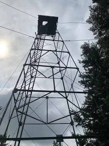
Rocky Mtn lived up to its name with rocky terrain, and it also had quite thick woods that I could see from the trail. It was cool to see the historic metal firetower which is exactly 100 years old now, and even though you can’t climb it, there are still some great views at the top.
Total hike time: less than 2 hours.
Total drive time: Let’s put it this way -
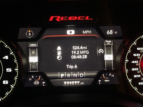
ONE WAY was 524 miles and took 8 hours and 48 minutes
(See photo, I timed the trip on the way home from where I parked on Rocky, to my driveway).
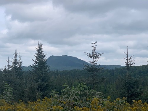
Rocky Mountain has a lot of prominence to the surrounding landscape:
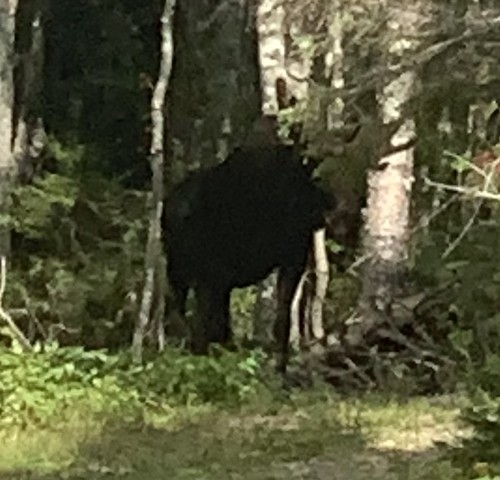
Giant Moose greeted me early in the hike, got a nice photo from a long distance away:
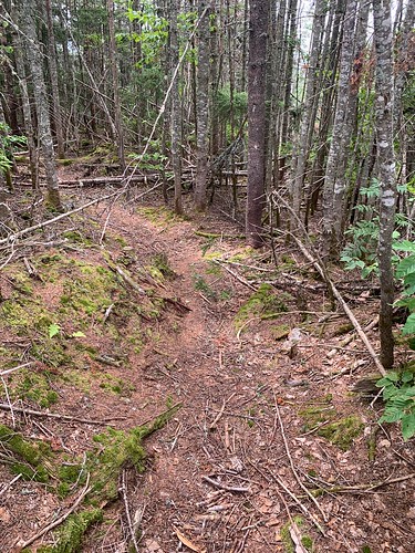
Old Firetower trail just before summit:
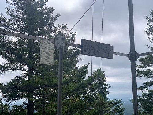
Rocky Mountain Firetower. 100 years old as of 2021:
Historic Lookout Register:
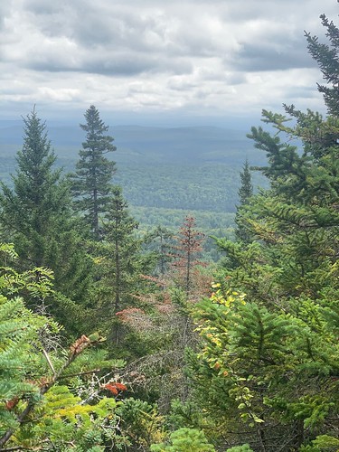
View from summit:
524 miles ONE-WAY from Vermont to Rocky Mountain. Almost 9 hr drive one way.
Here’s a mountain way out in the sticks that perhaps none of you have done:
Rocky Mountain 2010’, Maine.
And a new all-time ludicrous record has been set for the hike/drive ratio.
It’s all about Page 66 on the Maine DeLorme Atlas….
….I had always wanted to venture to the extreme northernmost part of Maine. This weekend the hurricane was coming in and that part of Maine was seemingly the only part of the Northeast that called for some decent weather.
My wife Renee was busy, so I hopped in the truck for the short, quick ‘n easy drive to ROCKY MOUNTAIN 2010’ which is about 20 miles BEYOND Allagash, Maine.
Saturday I drove to the Katahdin Valley Motel and spent the night, and then continued to Rocky this Sunday morning and drove home in the afternoon.
This part of Maine is so far north it is already late Winter there.
I swear if I drove another mile I would’ve run into Santa’s workshop, elves and Blitzen.
The area reminded me a lot of Pittsburg, NH. Also, it was cool to see the St John River and Allagash waterway.
I went through the checkpoint at Little Black. The lady running the checkpoint was one of the nicest people ever and helped me with directions to Rocky. I then continued from the Little Black Checkpoint and went through the automated Dickey checkpoint.
I continued driving after that about 10-11 miles on really good log roads to the base of Rocky Mountain. I parked at a fork.
As far as I can remember, one could have ostensibly kept driving about another half mile or so to a gate on a rough road, but I welcomed the extra walking since I had been sitting in the truck driving since like the Eisenhower administration.
Rocky Mtn is really cool in that it rises higher than all the surrounding landscape for miles. There is only 1 ascent entry on Peakbagger from someone who climbed it 60 years ago.
It also appears to be the only peak that rises above 2000’ on Page 66, and beyond - including a vast area of the northernmost Maine woods.
This mountain has been alluring to me for a long time and the extreme northern part of Maine was the last region of New England I had never explored.
I followed the old fire warden’s trail past the gate, which has since been widened, to the summit.
Rocky Mtn lived up to its name with rocky terrain, and it also had quite thick woods that I could see from the trail. It was cool to see the historic metal firetower which is exactly 100 years old now, and even though you can’t climb it, there are still some great views at the top.
Total hike time: less than 2 hours.
Total drive time: Let’s put it this way -
ONE WAY was 524 miles and took 8 hours and 48 minutes
(See photo, I timed the trip on the way home from where I parked on Rocky, to my driveway).
Rocky Mountain has a lot of prominence to the surrounding landscape:
Giant Moose greeted me early in the hike, got a nice photo from a long distance away:
Old Firetower trail just before summit:
Rocky Mountain Firetower. 100 years old as of 2021:
Historic Lookout Register:
View from summit:
524 miles ONE-WAY from Vermont to Rocky Mountain. Almost 9 hr drive one way.
")