
We came (via CVR), we saw (contrary to the forecast), we kicked A.S.S. (Abraham, Spaulding, Sugarloaf)
Today Bob & I got the news from Eddie - they were going to sleep in - so we got a 10-minute head start for the CVR. It was misting and Sugarloaf was in the clouds. The forecast was for only a so-so say with a lot of cloud cover and chance of rain, decreasing as the day went on, except for a chance (30%) of T-storms later on. We're here to bag peaks... let's go get some peaks!
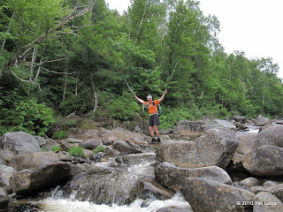
Crossing the river, First viewpoint into the valley
Crossing the Carabassett River was no problem as there was a plank to span some larger rocks. After a short section along the river, the river bears to the right and the trail to the left and the real climbing begins. It is very steep with no switchbacks and mostly over large boulders. With the mist, footing was a bit sketchy. After gaining all the elevation rapidly, the trail comes to a pair of consecutive viewpoints - reminiscent of the viewpoint on the Jewell - and then levels off some to climb gently to the junction with the Sugarloaf Spur Trail.
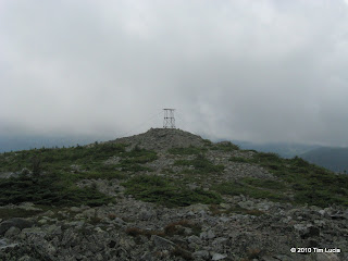
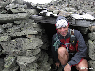
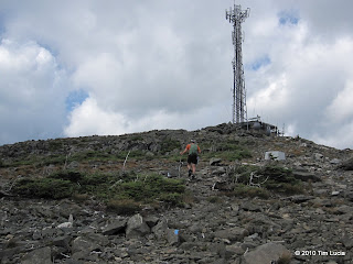
Summit tower on Abraham, Checking out the shelter
Because of the forecast for clearing later on, we followed the AT straight to the Abraham Side Trail, to get the peaks on the way back in hopes of better views. It was a strategy that paid off nicely. The AT is muddy here and there, and full of slick roots. There is a new privy near the Crocker lean-to, and a section of trail beyond that which is in the process of being re-routed around some very slippery bog bridges.
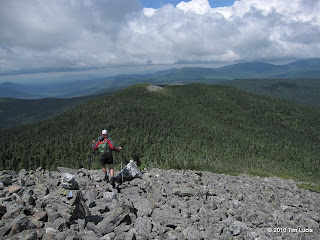
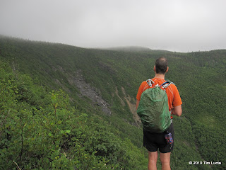
Descending Abraham, View to Spaulding and Sugarloaf
Bob & I disagreed on the distance of today's trip, but when we reached the slide trail, it turned out that it was the longer of the two distances at 17.4 miles. The side trail was a really nice trail of 1.6 miles each way. There are three separate scree/rock fields, including the final summit cone. At the second one, it became advisable to put on jackets as the wind was blowing pretty good (30-40) with an occasional gust that blew my footsteps around. We checked out the shelter which was unoccupied.
Once off the summit cone and rocks, we picked up speed on the return to the AT junction. It sprinkled occasionally on us but really only in this section. Near the lean-to is a spring, about 15 feet below the trail and we both filled up our hydration bladders. The col with Spaulding is rather deep and the climb back to the spur avoids the concept of switchbacks. I found it interesting that the elevation posted on the Spaulding summit sign is 3988, and it is a new sign too.
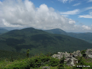
Viewpoint back to Abraham and Spaulding, Ascending the Sugarloaf summit cone
On the way to Sugarloaf we ran into a group of six, 4 teenage women and two chaperons that were doing the Maine AT section over 45 days - WITHOUT any trips to town, but with a weekly food drop - pretty hardcore. We also ran into a couple we'd seen on the Bigelows two days earlier - they are heading to Georgia. I expect to see them tomorrow on Saddleback/Horn. The ascent to Sugarloaf was pretty easy, part of the .6 miles was steep but part was not. Sadly my batteries in the camera died, but Bob was kind enough to let me copy his photos.
Descending the steep part of the AT was challenging as it came at mile 16+ and after 6000' +/-, but we made it back to the car in a round-trip time of 9:15. There was a red Jeep Wrangler out driving the CVR (came from beyond the AT crossing, not sure how far) for fun.
All Photos
Tomorrow: Saddleback and Saddleback/Horn before heading home.

Tim
Today Bob & I got the news from Eddie - they were going to sleep in - so we got a 10-minute head start for the CVR. It was misting and Sugarloaf was in the clouds. The forecast was for only a so-so say with a lot of cloud cover and chance of rain, decreasing as the day went on, except for a chance (30%) of T-storms later on. We're here to bag peaks... let's go get some peaks!
Crossing the river, First viewpoint into the valley
Crossing the Carabassett River was no problem as there was a plank to span some larger rocks. After a short section along the river, the river bears to the right and the trail to the left and the real climbing begins. It is very steep with no switchbacks and mostly over large boulders. With the mist, footing was a bit sketchy. After gaining all the elevation rapidly, the trail comes to a pair of consecutive viewpoints - reminiscent of the viewpoint on the Jewell - and then levels off some to climb gently to the junction with the Sugarloaf Spur Trail.
Summit tower on Abraham, Checking out the shelter
Because of the forecast for clearing later on, we followed the AT straight to the Abraham Side Trail, to get the peaks on the way back in hopes of better views. It was a strategy that paid off nicely. The AT is muddy here and there, and full of slick roots. There is a new privy near the Crocker lean-to, and a section of trail beyond that which is in the process of being re-routed around some very slippery bog bridges.
Descending Abraham, View to Spaulding and Sugarloaf
Bob & I disagreed on the distance of today's trip, but when we reached the slide trail, it turned out that it was the longer of the two distances at 17.4 miles. The side trail was a really nice trail of 1.6 miles each way. There are three separate scree/rock fields, including the final summit cone. At the second one, it became advisable to put on jackets as the wind was blowing pretty good (30-40) with an occasional gust that blew my footsteps around. We checked out the shelter which was unoccupied.
Once off the summit cone and rocks, we picked up speed on the return to the AT junction. It sprinkled occasionally on us but really only in this section. Near the lean-to is a spring, about 15 feet below the trail and we both filled up our hydration bladders. The col with Spaulding is rather deep and the climb back to the spur avoids the concept of switchbacks. I found it interesting that the elevation posted on the Spaulding summit sign is 3988, and it is a new sign too.
Viewpoint back to Abraham and Spaulding, Ascending the Sugarloaf summit cone
On the way to Sugarloaf we ran into a group of six, 4 teenage women and two chaperons that were doing the Maine AT section over 45 days - WITHOUT any trips to town, but with a weekly food drop - pretty hardcore. We also ran into a couple we'd seen on the Bigelows two days earlier - they are heading to Georgia. I expect to see them tomorrow on Saddleback/Horn. The ascent to Sugarloaf was pretty easy, part of the .6 miles was steep but part was not. Sadly my batteries in the camera died, but Bob was kind enough to let me copy his photos.
Descending the steep part of the AT was challenging as it came at mile 16+ and after 6000' +/-, but we made it back to the car in a round-trip time of 9:15. There was a red Jeep Wrangler out driving the CVR (came from beyond the AT crossing, not sure how far) for fun.
All Photos
Tomorrow: Saddleback and Saddleback/Horn before heading home.
Tim
 Nice job, that's a pretty big hike. What do you have for elevation gain?