
Mudrat
Member
PICTURES
I sat in my office on Friday the 14th glumly contemplating the next day's hike…something of Neil’s creation this time. Freezing rain encased the trees in a clear glaze. The precipitation turned into rain by late morning; the day felt heavy. Later, while sleeping in my car in preparation for an early start, I listened to it beat a lament on my windshield. I had no desire to hike in the rain in combination with winter conditions; both sets of gear was packed none-the-less.
Awakening at 4:30 a.m., Neil and I readied ourselves. The rain had tapered to an intermittent mist/sleet and the temperature was a balmy 33F. I was content with the change. It took us a bit to get moving toward our first challenge--fording the Hudson River. It was about 12-18" deep where we crossed and the current was strong (or I was weak). I felt the cold rush of water on both feet as my garbage bag armour was pierced from below. Thus began the adventure. We wrung our socks out on the other side of the river as I grumbled...not a good start. The temps wouldn't drop below the 20's at elevation, so we continued.
Lake Jimmy's plank walkway is defunct and a herd-path now follows the shoreline. The unsupportive snow made it arduous and another crossing of its outlet was done on a balance beam of fallen cedars. After this 20-minute detour we were finally on our way and once again owned warm feet. Crossing the Opalescent a couple miles later was a blessedly dry rock hop/jump.
10:30 a.m. found us at Allen Brook where the real work began. The brook was thickly encrusted with ice and offered a great alternative to walking up along the woods and navigating tangles of trees, deadfall and the ups/downs of the forest floor. Soon enough, we were forced back into the woods, alternating sides occasionally. Martin tracks led the way for a surprisingly long stretch before veering off our course along the brook (60 degrees magnetic).
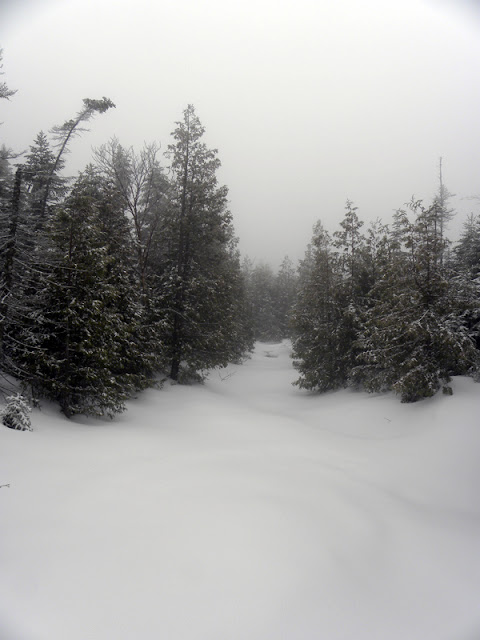
In what seemed like a short period of time (compared with my last trek up Skylight Brook in 2009), we reached the deeply recessed brook draining Redfield Slide (about 3 hours' bushwhack) to the north of our position. This would be our longest break of the day, about 10 minutes, as I readied my water for rest of the trek. In hindsight, I should have waited until after the swamp, but better safe than sorry. Our next target was the swamp about 1.2 miles from Allen Brook. The land flattened as we approached. It was an eerie scene since the cloud ceiling and intermittent precipitation shut down the views beyond a couple hundred feet.
Neil walked ahead as I photographed the area. The inflection suddenly changed in his voice as he yelled; he was excited about something. As I broke through the trees, I saw what looked like a white highway; Skylight Brook was frozen over. Its gently rolling surface was like a paved road that disappeared in the trees beyond. Neil said, "This is almost like cheating!" Too bad we couldn't cheat the rest of the way, I thought.
 "
"
This is almost like cheating!"
A hundred yards farther, we found a few open places where the clear water rushed within view and skirted on the side. That's when the day got 'interesting'.
Neil was leading and I heard a crack as his foot broke through. Time slowed…he pitched forward with the other foot to catch his balance and a 3 foot hole suddenly caved in. Neil was suddenly standing on the bottom of the brook in about 3 feet of water…mid thigh. I rushed over, but he'd extracted himself. Lifting his feet high, he drained his gaiters and assessed. The humor came back into his eyes when he realized he wasn’t completely soaked. That's when I repeated his phrase, "This is almost like cheating?" I’ve never seen him look at me as he did! Fortunately, he was far too far away to slug me...
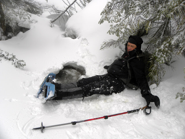
Swimming in Skylight Brook.
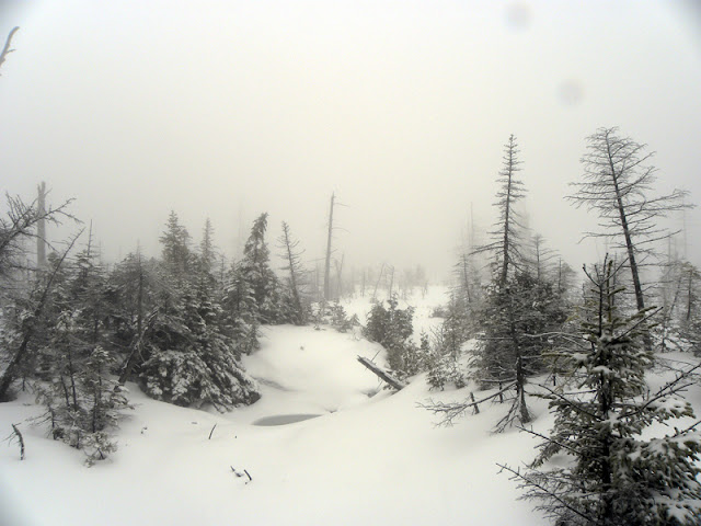
We were well over 7 miles from the trailhead. It would only get colder and windier. Movement was the best way to keep warm, either by heading back or continuing. I questioned him and he chose to continue...it was becoming a true Adirondack adventure and we had extra dry gear if needed. On hundred feet beyond we reached the swamp. It was obviously a wide open area, but we couldn't see across. On a clear day; Skylight, McDonnel, Redfield and Allen would be quite a sight.
We stepped away from the edge on a heading of 60 degrees. There was no warning. “Splash” Luckhurst broke through the ice a second time and extricated himself even more quickly. I decided to quash any one-liners, but was too concerned to materialize a good one anyway.
Ethereal Swamp...send donation to ADKHP Foundation and the spectacular surrounding HP views will magically appear.
We decided to trace the outside edge of the swamp around the left-hand side. He'd done his time as 'poison tester' and I tentatively led the way looking for trees or shrubs poking through and avoiding any smooth tracks that might indicate water. A few minutes later we found a feeder stream and followed it. This was actually the 6 foot wide drainage that led to the col left of the Spire, Skylight's southwest shoulder. Eventually, we crossed as it tracked in the wrong direction. We were now off our trajectory along Skylight Brook, but had fun following the ‘rule of up’. It all led to the summit…eventually.
Soon after the drainage, the slope of Skylight got steeper, the climbing more challenging. The support of the snowpack was never an issue. The inch or so of new snow/sleet, however, was annoying unless we climbed directly upward. Unfortunately, we needed to side-slope for quite some time. The snowshoes had a tendency to slide without the crampon portion biting fully. Intermittent sections of tightly knit forest slowed occasionally, but we usually found acceptable corridors through which to progress. Throughout, I played the game of managing my sugar intake and struggled to maintain a proper balance of blood sugar.
Primary navigation never changed; we checked the compass and topo map at regular intervals in the thick mist. We guessed at our general location on the flank of the broad mountain and believed we were slightly east of the spire as the time neared 3:00 p.m. (In hindsight, we were correct). Slight nuances and depressions in the landscape gave the impression of being near a drainage at around 4,000 feet in elevation (perhaps a little higher), but there was none upon exploration. We were about 1/10 of a mile west from the upper portions of Skylight Brook.
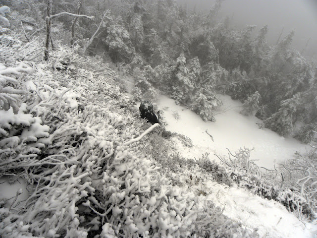
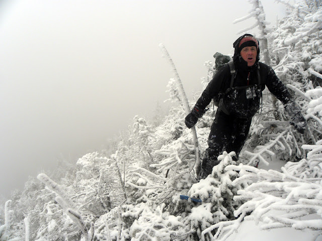
At around 4,500 feet in elevation, an opening in the distance heralded a change in topography. A small snowfield followed by a 60 degree face of rock and scrub led to the cripplebrush above: the ridge! I chose the shortest path using my ski pole as a make-shift ice ax and kicking the snowshoe crampons into the surface as deeply as possible. It was about a 20 foot climb to a safe perch from which to wait for Neil. He chose a path slightly to the west. A few more minutes of climbing on 45 degree crust and spruce led to a slight leveling of the terrain. Our heading on the ridge was north-northeast up small successive bumps in the terrain. We briefly thought we were on the spire, but ruled it out as we continued to climb.
60 degree slope up the side of the ridge.
Digitally captured pain.
The whole endeavor now had an other-worldly feel, each ghostly knob guiding the way to the next. It suddenly became very flat with wide open snowfields between the taller spruce trees. Open rock suddenly appeared followed by the summit cairn. The time stood at 3:40 p.m. as we walked by the cairn with hardly a glance. It had been a long day, some 10 hours and 9+ miles of near constant motion to attain the summit. Our original thought of trekking over to Allen was a distant memory. We opted for the easy bailout route we’d pre-planned…a 10 mile walk via trail to Upper Works via Flowed Lands.
The journey out is of little significance other than to say we had some awesome conversations, rested at Uphill Lean-to, ate a late lunch and changed into dry layers. Flowed Lands was unsafe to cross (and Neil was sick of playing ‘poison tester’). We arrived back at the car at 8:30 p.m. after another fantastic and challenging Adirondack adventure. Congrats, Neil on your 44th High Peak bushwhack!
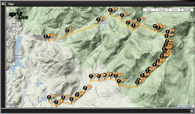
Most of our route (it's missing the first and last 30 minutes of route line).
I sat in my office on Friday the 14th glumly contemplating the next day's hike…something of Neil’s creation this time. Freezing rain encased the trees in a clear glaze. The precipitation turned into rain by late morning; the day felt heavy. Later, while sleeping in my car in preparation for an early start, I listened to it beat a lament on my windshield. I had no desire to hike in the rain in combination with winter conditions; both sets of gear was packed none-the-less.
Awakening at 4:30 a.m., Neil and I readied ourselves. The rain had tapered to an intermittent mist/sleet and the temperature was a balmy 33F. I was content with the change. It took us a bit to get moving toward our first challenge--fording the Hudson River. It was about 12-18" deep where we crossed and the current was strong (or I was weak). I felt the cold rush of water on both feet as my garbage bag armour was pierced from below. Thus began the adventure. We wrung our socks out on the other side of the river as I grumbled...not a good start. The temps wouldn't drop below the 20's at elevation, so we continued.
Lake Jimmy's plank walkway is defunct and a herd-path now follows the shoreline. The unsupportive snow made it arduous and another crossing of its outlet was done on a balance beam of fallen cedars. After this 20-minute detour we were finally on our way and once again owned warm feet. Crossing the Opalescent a couple miles later was a blessedly dry rock hop/jump.
10:30 a.m. found us at Allen Brook where the real work began. The brook was thickly encrusted with ice and offered a great alternative to walking up along the woods and navigating tangles of trees, deadfall and the ups/downs of the forest floor. Soon enough, we were forced back into the woods, alternating sides occasionally. Martin tracks led the way for a surprisingly long stretch before veering off our course along the brook (60 degrees magnetic).
In what seemed like a short period of time (compared with my last trek up Skylight Brook in 2009), we reached the deeply recessed brook draining Redfield Slide (about 3 hours' bushwhack) to the north of our position. This would be our longest break of the day, about 10 minutes, as I readied my water for rest of the trek. In hindsight, I should have waited until after the swamp, but better safe than sorry. Our next target was the swamp about 1.2 miles from Allen Brook. The land flattened as we approached. It was an eerie scene since the cloud ceiling and intermittent precipitation shut down the views beyond a couple hundred feet.
Neil walked ahead as I photographed the area. The inflection suddenly changed in his voice as he yelled; he was excited about something. As I broke through the trees, I saw what looked like a white highway; Skylight Brook was frozen over. Its gently rolling surface was like a paved road that disappeared in the trees beyond. Neil said, "This is almost like cheating!" Too bad we couldn't cheat the rest of the way, I thought.
This is almost like cheating!"
A hundred yards farther, we found a few open places where the clear water rushed within view and skirted on the side. That's when the day got 'interesting'.
Neil was leading and I heard a crack as his foot broke through. Time slowed…he pitched forward with the other foot to catch his balance and a 3 foot hole suddenly caved in. Neil was suddenly standing on the bottom of the brook in about 3 feet of water…mid thigh. I rushed over, but he'd extracted himself. Lifting his feet high, he drained his gaiters and assessed. The humor came back into his eyes when he realized he wasn’t completely soaked. That's when I repeated his phrase, "This is almost like cheating?" I’ve never seen him look at me as he did! Fortunately, he was far too far away to slug me...
Swimming in Skylight Brook.
We were well over 7 miles from the trailhead. It would only get colder and windier. Movement was the best way to keep warm, either by heading back or continuing. I questioned him and he chose to continue...it was becoming a true Adirondack adventure and we had extra dry gear if needed. On hundred feet beyond we reached the swamp. It was obviously a wide open area, but we couldn't see across. On a clear day; Skylight, McDonnel, Redfield and Allen would be quite a sight.
We stepped away from the edge on a heading of 60 degrees. There was no warning. “Splash” Luckhurst broke through the ice a second time and extricated himself even more quickly. I decided to quash any one-liners, but was too concerned to materialize a good one anyway.
Ethereal Swamp...send donation to ADKHP Foundation and the spectacular surrounding HP views will magically appear.
We decided to trace the outside edge of the swamp around the left-hand side. He'd done his time as 'poison tester' and I tentatively led the way looking for trees or shrubs poking through and avoiding any smooth tracks that might indicate water. A few minutes later we found a feeder stream and followed it. This was actually the 6 foot wide drainage that led to the col left of the Spire, Skylight's southwest shoulder. Eventually, we crossed as it tracked in the wrong direction. We were now off our trajectory along Skylight Brook, but had fun following the ‘rule of up’. It all led to the summit…eventually.
Soon after the drainage, the slope of Skylight got steeper, the climbing more challenging. The support of the snowpack was never an issue. The inch or so of new snow/sleet, however, was annoying unless we climbed directly upward. Unfortunately, we needed to side-slope for quite some time. The snowshoes had a tendency to slide without the crampon portion biting fully. Intermittent sections of tightly knit forest slowed occasionally, but we usually found acceptable corridors through which to progress. Throughout, I played the game of managing my sugar intake and struggled to maintain a proper balance of blood sugar.
Primary navigation never changed; we checked the compass and topo map at regular intervals in the thick mist. We guessed at our general location on the flank of the broad mountain and believed we were slightly east of the spire as the time neared 3:00 p.m. (In hindsight, we were correct). Slight nuances and depressions in the landscape gave the impression of being near a drainage at around 4,000 feet in elevation (perhaps a little higher), but there was none upon exploration. We were about 1/10 of a mile west from the upper portions of Skylight Brook.
At around 4,500 feet in elevation, an opening in the distance heralded a change in topography. A small snowfield followed by a 60 degree face of rock and scrub led to the cripplebrush above: the ridge! I chose the shortest path using my ski pole as a make-shift ice ax and kicking the snowshoe crampons into the surface as deeply as possible. It was about a 20 foot climb to a safe perch from which to wait for Neil. He chose a path slightly to the west. A few more minutes of climbing on 45 degree crust and spruce led to a slight leveling of the terrain. Our heading on the ridge was north-northeast up small successive bumps in the terrain. We briefly thought we were on the spire, but ruled it out as we continued to climb.
60 degree slope up the side of the ridge.
Digitally captured pain.
The whole endeavor now had an other-worldly feel, each ghostly knob guiding the way to the next. It suddenly became very flat with wide open snowfields between the taller spruce trees. Open rock suddenly appeared followed by the summit cairn. The time stood at 3:40 p.m. as we walked by the cairn with hardly a glance. It had been a long day, some 10 hours and 9+ miles of near constant motion to attain the summit. Our original thought of trekking over to Allen was a distant memory. We opted for the easy bailout route we’d pre-planned…a 10 mile walk via trail to Upper Works via Flowed Lands.
The journey out is of little significance other than to say we had some awesome conversations, rested at Uphill Lean-to, ate a late lunch and changed into dry layers. Flowed Lands was unsafe to cross (and Neil was sick of playing ‘poison tester’). We arrived back at the car at 8:30 p.m. after another fantastic and challenging Adirondack adventure. Congrats, Neil on your 44th High Peak bushwhack!
Most of our route (it's missing the first and last 30 minutes of route line).