WalksWithBlackflies
New member
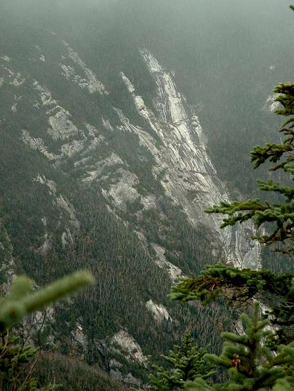
I needed to drop my wife off in Old Forge on Friday, so I was looking for a good hike in the southern High Peaks. I decided on the Dix Range; and MudRat and I further refined it to a Dix west face slide climb followed by some scouting for future potential hikes. Only after deciding on this hike did I log onto AdkHighPeaks and notice JoeCedar's thread about the West Face Slides... sorry if we stole your thunder. For no real reason, we decided to climb the left finger of the "V" slide (see "dixfromnippletop" photo, "V" slide is right-center of photo, to the left of the tall spruce).
We were on the trail at 5:30am. And we soon passed the Slide Brook lean-to (and the bear canister wedged beneath it) and the Lillian Brook lean-to. Continuing on, we reached a flat area with views of the "V" (left), "Triangle" (center) and "Devils Pitchfork" (right) slides, and angled down towards the mouth of the drainage that leads to the base of them. The bottom portion of the drainage was wet and slippery, but was navigated without too much problem. We also have photographic evidence that water DOES flow uphill in the Adks. There must have been a whopper of a storm this past week because there was new blowdown, erosion, and landslides begining about 1/3 of the way up the drainage. It was so fresh, that the leaves on the fallen trees hadn't even wilted yet. Some of the steep sidewalls of the drainage still looked very unstable.
At the split, we followed the north fork of the drainage to the base of the slide. There was much less blowdown on this fork, and the scrambling was a lot of fun. We quickly reached the base of the slide, and began our ascent. The rock is nice and grippy, and is filled with thousands of miniture "pot holes" just the right size for placing eggs in them. Unfortunately we didn't have thousands of eggs to test our theory. The slide is steep to very steep, and there is a lot of exposure (see photo "159"). Not a good beginner slide, but would pose little problem for "the initiated".
After a short but thick bushwhack from the top, we reached the summit. From there we hiked over to the Beckhorn. I had wanted to check out the top of the Beckhorn slide, but alas, I couldn't find it. I'm thinking that there is vegetation growing on this portion of the slide... need to look at my photos again.
From the Beckhorn, we hiked back over the summit and down to the intersection of the Hunters Pass/Round Pond trails. Veering onto the Hunters Pass trail, we scouted for the top of the Hunters Pass slides. Heading off trail at a small grassy area, we walked right to the top of the slide... and it was gorgeous. We had only planned on scouting the top and bottom of these slides. Based on photographs, they weren't climbable without technical gear (see "dixfromnippletop" photo, Hunters Slide is left-center of photo, spruce branches on left "point" to the slide). However, from our vantage point, they looked very climbable. We decided to scramble down the "finger" right in front of us to the main slide.
It was steep. Very, very steep; and strewn with benches that would require technical gear. We hugged the vegetation on the side of the slide when we'd reach the benches. MudRat continued down this finger, while I bushwhacked over to the adjacent finger where the grade was gentler. We met at the main slide and continued down. Indeed, there were sections with 200-foot drop-offs, but we were able to work our way around them without resorting to bushwhacking. After about an hour of moderately steep (see photo "187") to very steep toe-jamming descent (see photo "015"), we reached a waterfall with a 50-foot drop-off. We could not find an acceptable way down the cliff-face, so we hiked up the slide a bit until we found a good entrance into the woods and bushwhacked our way down. We found the slide again about 50 vertical feet below the falls. I hiked back up to take a photo of the falls, and realized that all we needed to do was climb over one rock at the top of the falls (to our left when we were heading down) and easily descend 25 feet down a nice gentle butress to the base of the falls.
This portion of the slide was nothing but a glorified creekbed, which soon turned into a loose debris field. After two minutes of hiking on this debris field, we reached the drainage coming from Hunters Pass. A downed birch tree provided easy access to the trail on the other side.
The hike out was uneventful, although it seemed to take longer than it actually did. Returning to the trailhead at 5:00, we reflected on what a great slide hike we had just completed.
Last edited: