Mudrat
Member
Date: 2013 May 4
Duration: 18 hours
Pack Weight & Gear: 30 pounds. Fleece layer, sleeping back, tons of food, 3L water, snowshoes, microspikes... equipment for overnight camping and snow.
Partner: Rich McKenna (WalksWithBlackflies)
Protection: eyewear, gloves, long sleeved shirt, long pants, shin guards (on Rich).
Route: Lewis Brook-east to Stewart-south toward Kilburn NE ridge-follow ridge and cross when tree-cover thickened-Sentinel Ridge-follow to Sentinel summit-WSW to Kilburn north drainage-south along base of Kilburn to North Notch-West to Riverside Drive.
PICTURES (and captions)
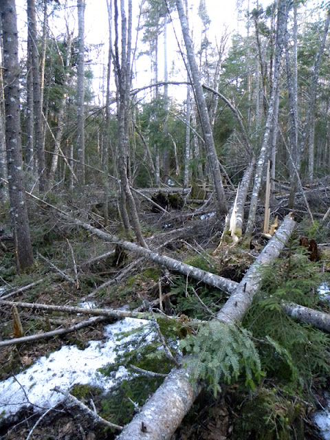
Just a quick taste of the NE ridge to Sentinel and it's SW slope.
Stewart Mountain:
The alarm sounded at 4:00 a.m. I woke WWBF and we stepped out my front door at 4:30 to embark upon what would become an 18-hour bushwhack. The first 40 minutes would take us over private and state lands to Lewis Brook (I had permission to cross the private tract).
A beautiful sunrise on a crisp cloudless morning illuminated the unleafed hardwood forest as our bodies rebelled against the early morning exertion. The flank of Stewart transitioned to softwoods after about 30 minutes of climbing, but progress was still quite easy on a heading just north of the summit proper toward the eastern ridgeline. A few ledges mixed in with the terrain as we crested the ridge. Once on top, the climbing was blessedly easy. Flexible firs and some small pockets of snow accompanied our climb to the final steep approach. I kept waiting for a 'crown of thorns' to slow progress up the northeastern side, but it never came in the density I'd anticipated. It tightened a bit, but was gently compared to some recent bushwhacks in the High Peaks. Dry conditions made the lichen on the trees friable and after an hour of inhaling the dust, I began a day-long allergy attack; part of my water intake seemed to constantly be draining from my nose…horrible!
Whiteface, bathed in a soft morning glow, looked magnificent through the trees. We took a quick break on the summit proper at 7:50 a.m. It had taken 3 hours and 20 minutes of less than brutal climbing; we were thrilled. (Note: My SPOT track didn’t pick up our signal while on actual summit.)
Trek to Sentinel Mountain:
Our next goal was Sentinel, a target so seemingly close at hand to the south over its northeastern ridge. The original plan routed us back down Stewart to the east in order to access Sentinel’s northern cirque. In hindsight, it’s good this didn’t work out partly due to the snow conditions and what looked like some gnarly tree related issues. We took a visual bearing and dropped down Stewarts SE slope via a series of precipitious ledges. The frost line was only about and inch down, so we each took a couple falls as the duff slid on the underlying ice. The wet ledges required forethought as we approached the edge and sought their weakest point. Other than Rich nearly breaking his finger, the elevation loss of 600-700 feet down the anorthositic woodland maze was interesting and went smoothly.
All the while, I reflected years back to when I walked from Wilmington Notch to Springfield Road via Stewart (I never reached the summit), flanking the mountain’s southern slope. I remember the ledges and the acres of cripplebrush just to their east that cut my arms and torso quite badly…I wasn’t prepared at the time. This was easy by comparison. We soon found ourselves crossing the gently sloped end of Kilburn’s NE ridge—open woods with light blowdown.
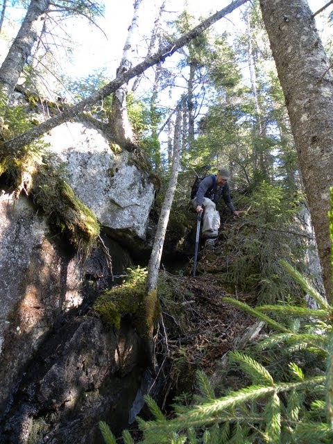
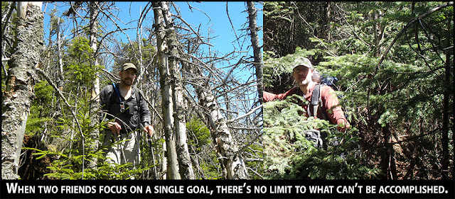
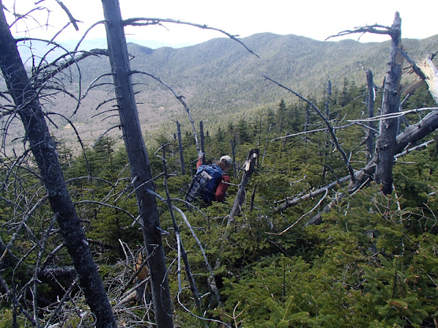
Rich descending one of dozens of ledge en this side of the mountain.
The progress was so easy that we followed the ridge within earshot of Lewis Brook until it began to close in with fir at roughly 3,100 feet in elevation. We’d drained our water supply of 2L by that time and decided to cross the brook to ascend Sentinel’s ridge. Thankfully, we crossed at this point since the brook was covered in 3-4 feet of rotten snow. I heard water running below and punched through using trekking poles. The water was a full three feet lower than the snow so filling the nalgene bottles for processing with a steripen involved either doing a partial split or Rich holding my arm as I leaned down. Video would have captured the moment in its full hilarity and lack of grace.
A full 3L heavier, we then began to climb the series of small ledges on the ridge. Ice and some snow complicated it slightly. Once above, the woods were moderatly woven with some intermittently steep climbing. Our goal was to cross over the ridge and explore the opposite side; we traveled the crest for as long as it was comfortable.
The trees stunted with elevation gain as is normal and side sloping on the left-hand side worked very briefly; it was loaded with blowdown. The choices narrowed to either hurdling deadfall or forcing our way through fir and spruce. We chose the latter for the next hour. A small erratic sat on top of the second to last knob and yielded a fabulous perch from which to view the surrounding ridge-lines and mountains. A day that started in the 40’s had heated to about 76F in the shade. Sitting in patches of snow cooled my core temperature from below…
We chose a different tact on the last section of ridge in lieu of combating the stiff spruce and blowdown. We dropped off the left-hand side of the ridge by about 50 feet and, after putting on microspikes simply navigated mild deadfall and side-sloping in mixed conditions. We set a heading for the summit proper below an obvious wave of secondary grown and dead spruce. Roughly 5 hours after leaving Stewart’s summit, we found ourselves on Sentinel proper reading the sign at 12:50 p.m.
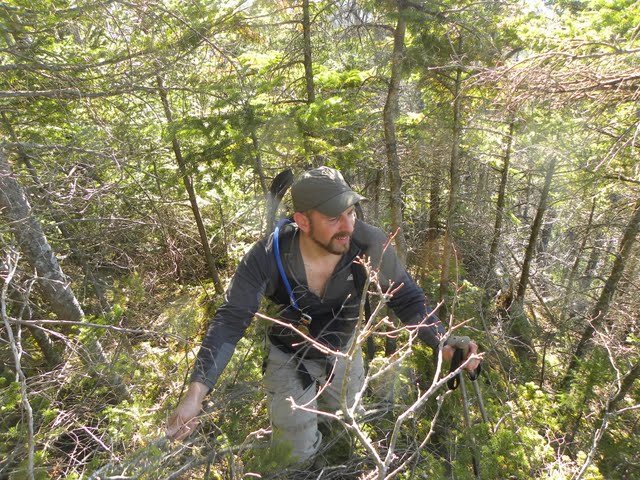
Rich climbing up on some rotten deadfall on the side of Sentinel's NE ridge.
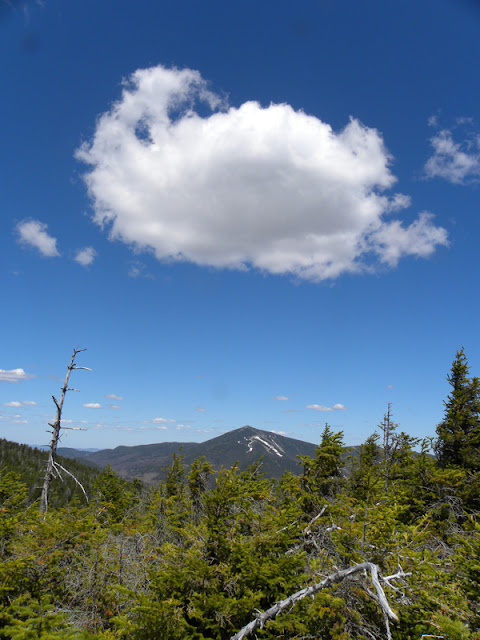
Our only open respite on the ridge before Sentinel yielded a stellar view of Whiteface.
Traverse to Kilburn
The next segment seemed like a good idea, but utterly destroyed any hope of traversing the Sentinel Range. We wanted to avoid the long ridge traverse. The forest at about 3,300’ in elevation seemed (key word) more loosely knit…not so much in reality. We began on a line of sight heading for Kilburn’s summit into the belly of the beast. Snow was no longer an issue due to the southern exposure. The woods were among the most tightly knit in the area. This, we expected, though it took us an hour to shed 300 vertical feet of elevation during which Rich lost a snowshoe…rudely yanked from beneath two tie down straps by a tree. He tried to retrace, but couldn’t find his own footprints. That cast the first shadow on our traverse to Kilburn.
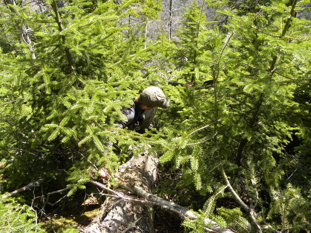
Yup, it was this bad for a while...then it closed in.
Below, the trees grew larger, but secondary growth was still extremely tight. Our pace was slow and gravity did little to aid progress. Multiple acres of blowdown intermingled with networks of dense balsams riddled the mountainside as we traversed to our lowest point at the primary drainage from the Kilburn/Sentinel col. A small feeder stream just prior, refilled our bladders with another 2L; we’d used 3L of water ascending/descending Sentinel. The time stood at about 3:30 p.m. Our cameras were packed during the next three hours due to our dark mood and the conditions.
I hoped for a loosening of the forest as we chaned exposure along Kilburn’s ridge. Open areas with rotten blowdown were the most gentle areas we found. Fir ruled the landscape as we neared the northern drainage of Kilburn’s summit. The ridge, made of multiple bumps, each seem to have a drainage and small ridge associated with them. Each ridge running down occluded the sun enough to retain 3-4 feet of rotten snow. What was already a daughting challenge became a nearly hopeless task as we fought the fields of balsam amidst the snow. We were averaging less than ¼ mile per hour in some locations and, in the process of trying to get out of the snow, lost another hundred or so feet of elevation. There was no rational way upward given the conditions. Admitting defeat, we gave up the summit bid at about 4:30. We assessed bail-out options and chose to exit via North Notch.
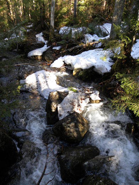
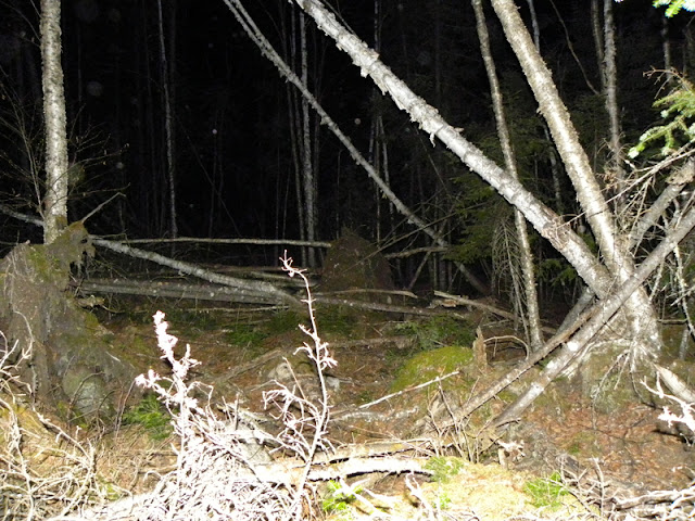
Kilburn runoff stream.
Duration: 18 hours
Pack Weight & Gear: 30 pounds. Fleece layer, sleeping back, tons of food, 3L water, snowshoes, microspikes... equipment for overnight camping and snow.
Partner: Rich McKenna (WalksWithBlackflies)
Protection: eyewear, gloves, long sleeved shirt, long pants, shin guards (on Rich).
Route: Lewis Brook-east to Stewart-south toward Kilburn NE ridge-follow ridge and cross when tree-cover thickened-Sentinel Ridge-follow to Sentinel summit-WSW to Kilburn north drainage-south along base of Kilburn to North Notch-West to Riverside Drive.
PICTURES (and captions)
Just a quick taste of the NE ridge to Sentinel and it's SW slope.
Stewart Mountain:
The alarm sounded at 4:00 a.m. I woke WWBF and we stepped out my front door at 4:30 to embark upon what would become an 18-hour bushwhack. The first 40 minutes would take us over private and state lands to Lewis Brook (I had permission to cross the private tract).
A beautiful sunrise on a crisp cloudless morning illuminated the unleafed hardwood forest as our bodies rebelled against the early morning exertion. The flank of Stewart transitioned to softwoods after about 30 minutes of climbing, but progress was still quite easy on a heading just north of the summit proper toward the eastern ridgeline. A few ledges mixed in with the terrain as we crested the ridge. Once on top, the climbing was blessedly easy. Flexible firs and some small pockets of snow accompanied our climb to the final steep approach. I kept waiting for a 'crown of thorns' to slow progress up the northeastern side, but it never came in the density I'd anticipated. It tightened a bit, but was gently compared to some recent bushwhacks in the High Peaks. Dry conditions made the lichen on the trees friable and after an hour of inhaling the dust, I began a day-long allergy attack; part of my water intake seemed to constantly be draining from my nose…horrible!
Whiteface, bathed in a soft morning glow, looked magnificent through the trees. We took a quick break on the summit proper at 7:50 a.m. It had taken 3 hours and 20 minutes of less than brutal climbing; we were thrilled. (Note: My SPOT track didn’t pick up our signal while on actual summit.)
Trek to Sentinel Mountain:
Our next goal was Sentinel, a target so seemingly close at hand to the south over its northeastern ridge. The original plan routed us back down Stewart to the east in order to access Sentinel’s northern cirque. In hindsight, it’s good this didn’t work out partly due to the snow conditions and what looked like some gnarly tree related issues. We took a visual bearing and dropped down Stewarts SE slope via a series of precipitious ledges. The frost line was only about and inch down, so we each took a couple falls as the duff slid on the underlying ice. The wet ledges required forethought as we approached the edge and sought their weakest point. Other than Rich nearly breaking his finger, the elevation loss of 600-700 feet down the anorthositic woodland maze was interesting and went smoothly.
All the while, I reflected years back to when I walked from Wilmington Notch to Springfield Road via Stewart (I never reached the summit), flanking the mountain’s southern slope. I remember the ledges and the acres of cripplebrush just to their east that cut my arms and torso quite badly…I wasn’t prepared at the time. This was easy by comparison. We soon found ourselves crossing the gently sloped end of Kilburn’s NE ridge—open woods with light blowdown.
Rich descending one of dozens of ledge en this side of the mountain.
The progress was so easy that we followed the ridge within earshot of Lewis Brook until it began to close in with fir at roughly 3,100 feet in elevation. We’d drained our water supply of 2L by that time and decided to cross the brook to ascend Sentinel’s ridge. Thankfully, we crossed at this point since the brook was covered in 3-4 feet of rotten snow. I heard water running below and punched through using trekking poles. The water was a full three feet lower than the snow so filling the nalgene bottles for processing with a steripen involved either doing a partial split or Rich holding my arm as I leaned down. Video would have captured the moment in its full hilarity and lack of grace.
A full 3L heavier, we then began to climb the series of small ledges on the ridge. Ice and some snow complicated it slightly. Once above, the woods were moderatly woven with some intermittently steep climbing. Our goal was to cross over the ridge and explore the opposite side; we traveled the crest for as long as it was comfortable.
The trees stunted with elevation gain as is normal and side sloping on the left-hand side worked very briefly; it was loaded with blowdown. The choices narrowed to either hurdling deadfall or forcing our way through fir and spruce. We chose the latter for the next hour. A small erratic sat on top of the second to last knob and yielded a fabulous perch from which to view the surrounding ridge-lines and mountains. A day that started in the 40’s had heated to about 76F in the shade. Sitting in patches of snow cooled my core temperature from below…
We chose a different tact on the last section of ridge in lieu of combating the stiff spruce and blowdown. We dropped off the left-hand side of the ridge by about 50 feet and, after putting on microspikes simply navigated mild deadfall and side-sloping in mixed conditions. We set a heading for the summit proper below an obvious wave of secondary grown and dead spruce. Roughly 5 hours after leaving Stewart’s summit, we found ourselves on Sentinel proper reading the sign at 12:50 p.m.
Rich climbing up on some rotten deadfall on the side of Sentinel's NE ridge.
Our only open respite on the ridge before Sentinel yielded a stellar view of Whiteface.
Traverse to Kilburn
The next segment seemed like a good idea, but utterly destroyed any hope of traversing the Sentinel Range. We wanted to avoid the long ridge traverse. The forest at about 3,300’ in elevation seemed (key word) more loosely knit…not so much in reality. We began on a line of sight heading for Kilburn’s summit into the belly of the beast. Snow was no longer an issue due to the southern exposure. The woods were among the most tightly knit in the area. This, we expected, though it took us an hour to shed 300 vertical feet of elevation during which Rich lost a snowshoe…rudely yanked from beneath two tie down straps by a tree. He tried to retrace, but couldn’t find his own footprints. That cast the first shadow on our traverse to Kilburn.
Yup, it was this bad for a while...then it closed in.
Below, the trees grew larger, but secondary growth was still extremely tight. Our pace was slow and gravity did little to aid progress. Multiple acres of blowdown intermingled with networks of dense balsams riddled the mountainside as we traversed to our lowest point at the primary drainage from the Kilburn/Sentinel col. A small feeder stream just prior, refilled our bladders with another 2L; we’d used 3L of water ascending/descending Sentinel. The time stood at about 3:30 p.m. Our cameras were packed during the next three hours due to our dark mood and the conditions.
I hoped for a loosening of the forest as we chaned exposure along Kilburn’s ridge. Open areas with rotten blowdown were the most gentle areas we found. Fir ruled the landscape as we neared the northern drainage of Kilburn’s summit. The ridge, made of multiple bumps, each seem to have a drainage and small ridge associated with them. Each ridge running down occluded the sun enough to retain 3-4 feet of rotten snow. What was already a daughting challenge became a nearly hopeless task as we fought the fields of balsam amidst the snow. We were averaging less than ¼ mile per hour in some locations and, in the process of trying to get out of the snow, lost another hundred or so feet of elevation. There was no rational way upward given the conditions. Admitting defeat, we gave up the summit bid at about 4:30. We assessed bail-out options and chose to exit via North Notch.
Kilburn runoff stream.
Last edited: