
Jazzbo
Well-known member
- Joined
- Jan 1, 2005
- Messages
- 1,197
- Reaction score
- 163
Last fall I hiked up Dorset Peak from the hollow. I visited the abandoned fire tower and left thinking I’d bagged that summit. Then I checked out Bog&Gerri’s web page and my study of their GPS track indicated I’d missed out on the main peak with the canister. I might have let it pass except I was very curious to try re-visiting the peak using an approach from the north side which I don’t recall ever see reports on.
Going through the notch where trail heads east I'd been impressed with the beauty of the trail (more like a road actually) coming up from north side. The trail looked to be in excellent shape and not at all abandoned. From the topographic map it looked like a very nice grade.
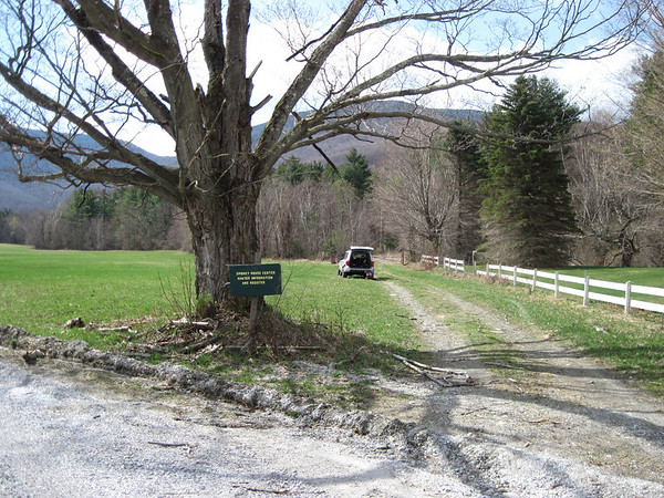
I arrived at the trailhead last Sunday morning after a very scenic drive through early spring in the mountains. I came up via Brook Road from Danby off of Route 7. The trail/road begins right at the 90 degree bend in Edmonds Road shown on Page 25 of the Delorme guide. I was wondering about private property issues, but fact that there is a register and the fact that the register featured a sign reading “Smokey House Center Hunter Information and Register” appeared to indicate visitors are expected and welcomed.
I signed in to the register just in case law enforcement should come to investigate my parked vehicle.
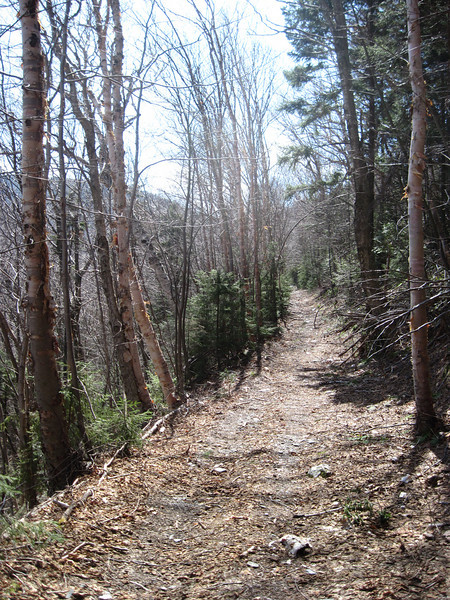
The road is a breeze to hike on and I soon came to a fork in the road. Based on my interpretation of the map I carried and my observations of the terrain I opted to go left. This proved to be a mistake since the road came to an abrupt end at an elevation 0f 2100’. I knew the notch was approximately 3000’ and with Dorset Notch still pretty far overhead and to the south. I figured I guessed wrong back at the fork and the actual road must be directly overhead. I bushwhacked directly up slope with the idea of meeting up with the road. It was extremely steep, but very wide open, not a bit thick, and very dry. Sure enough after about 500 feet of climbing, I reached the trail road at 2650’. Hiking the road continued to be a piece of cake to hike. You can make out the notch straight ahead in this photo.
Snow line was at 2800’. I stopped at the notch to have a bite to eat and don my snowshoes only an hour and ten minutes from the car.
I continued snow shoeing up the side hill trail at a gentle grade on an east bearing. I passed by the first trail that splits off right since it was the one that led me to the false summit last fall. I passed another trail that split off to the right figuring I’d go as far as possible on the east bound trail and come up over the summit from the east.
Someone come through and brushed the road to it’s full width and left the trail littered with boughs. You could tell it was a snowmobiler because they also sawed trees and blow downs. The tree stumps were cut high 3-4’ high like they’d been cut in deep snow.
This was confirmed at the canister when I read an entry by the snowmobiler stating he had brushed the trail and how he’d had a good ride. There was one hiker entry who had been by in March, but that was about it for entries.
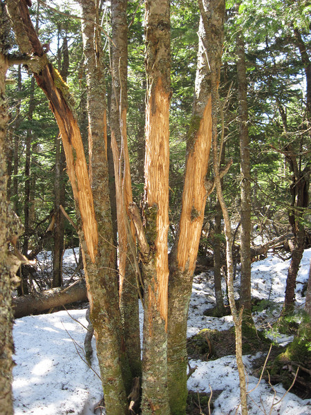
I was impressed with extensive de-barking of the spruce trees at the summit.
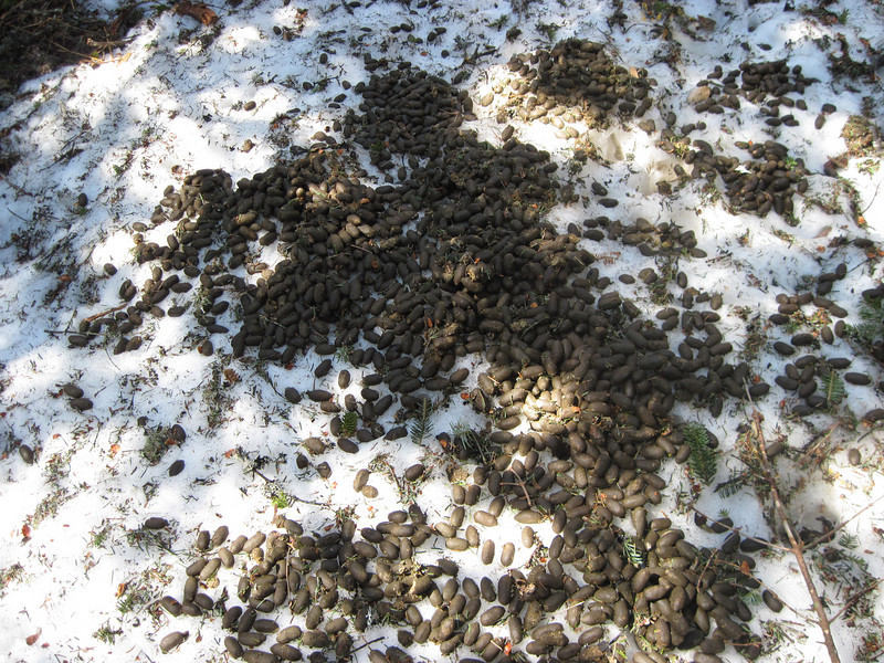
I wandered around to investigate and was amazed at the huge volumes of moose droppings. This was just one of 4 or 5 in one area.
I found much much more de-barking. It stuck me that the moose were doing more than just using the trees to drop antlers and must have been eating the spruce bark.
I skipped the false summit and headed down directly. The trail/road was even nicer to descend on. I came to the fork where I took the wrong turn. It was at 1800’ elevation. This hike took me only 4.5 hours even with my wrong turn + bushwhack + wandering around looking at moose sign. Now I’ve seen Dorset Peak from both sides now.
Going through the notch where trail heads east I'd been impressed with the beauty of the trail (more like a road actually) coming up from north side. The trail looked to be in excellent shape and not at all abandoned. From the topographic map it looked like a very nice grade.
I arrived at the trailhead last Sunday morning after a very scenic drive through early spring in the mountains. I came up via Brook Road from Danby off of Route 7. The trail/road begins right at the 90 degree bend in Edmonds Road shown on Page 25 of the Delorme guide. I was wondering about private property issues, but fact that there is a register and the fact that the register featured a sign reading “Smokey House Center Hunter Information and Register” appeared to indicate visitors are expected and welcomed.
I signed in to the register just in case law enforcement should come to investigate my parked vehicle.
The road is a breeze to hike on and I soon came to a fork in the road. Based on my interpretation of the map I carried and my observations of the terrain I opted to go left. This proved to be a mistake since the road came to an abrupt end at an elevation 0f 2100’. I knew the notch was approximately 3000’ and with Dorset Notch still pretty far overhead and to the south. I figured I guessed wrong back at the fork and the actual road must be directly overhead. I bushwhacked directly up slope with the idea of meeting up with the road. It was extremely steep, but very wide open, not a bit thick, and very dry. Sure enough after about 500 feet of climbing, I reached the trail road at 2650’. Hiking the road continued to be a piece of cake to hike. You can make out the notch straight ahead in this photo.
Snow line was at 2800’. I stopped at the notch to have a bite to eat and don my snowshoes only an hour and ten minutes from the car.
I continued snow shoeing up the side hill trail at a gentle grade on an east bearing. I passed by the first trail that splits off right since it was the one that led me to the false summit last fall. I passed another trail that split off to the right figuring I’d go as far as possible on the east bound trail and come up over the summit from the east.
Someone come through and brushed the road to it’s full width and left the trail littered with boughs. You could tell it was a snowmobiler because they also sawed trees and blow downs. The tree stumps were cut high 3-4’ high like they’d been cut in deep snow.
This was confirmed at the canister when I read an entry by the snowmobiler stating he had brushed the trail and how he’d had a good ride. There was one hiker entry who had been by in March, but that was about it for entries.
I was impressed with extensive de-barking of the spruce trees at the summit.
I wandered around to investigate and was amazed at the huge volumes of moose droppings. This was just one of 4 or 5 in one area.
I found much much more de-barking. It stuck me that the moose were doing more than just using the trees to drop antlers and must have been eating the spruce bark.
I skipped the false summit and headed down directly. The trail/road was even nicer to descend on. I came to the fork where I took the wrong turn. It was at 1800’ elevation. This hike took me only 4.5 hours even with my wrong turn + bushwhack + wandering around looking at moose sign. Now I’ve seen Dorset Peak from both sides now.