
Mudrat
Member
Disclaimer
PICTURES
On my annual 3 days of sliding and bushwhacking, I decided to play on Dix, Giant and a few other mountains. WalkWithBlackflies (Rich) and I entered via AMR Friday night, setting up camp a few hundred yards from Dix’ northern Finger Slides at around midnight. We joked all the way in, but somehow didn’t manage to awaken the horde of campers at the N. Boquet Lean-to as we passed through. I think we both intended to overnight at the site since we were tired, but that dream evaporated instantly.
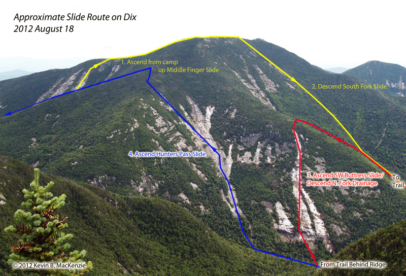
Dix Ring Finger Slide
There was much animal activity during the evening culminating with a porcupine chewing its way through the area and, as Rich said, an “alarm hornet” at 6:00 a.m., curious about about what manner of creature was sleeping under a yellow sil-nylon tarp. Perhaps it was attracted to all the sap that had dripped on the tarp from the birch overnight. I had the alarm set for 6:30 a.m. anyway. We were slowly walking upward by 6:45. We ate a light breakfast on the “Wrist” area of the slide array and filled our water bladders with 3 liters of tasty mountain water. 8:00 a.m. saw us at the steep foot-wall of the center “Ring Finger”. It was still shielded from the sun by Dix’ ridge, washed in a shadow that kept the rock cold underfoot. It was in the low 50’s (F).
The climb was without drama even though we (Rich especially) took the most difficult lines toward and up any ledges en route. Especially interesting was a convex ledge with complex layering. A carpet of moss decorated the steep slab at its base, however. I remember watching Rich explore it as I climbed my own vertical, albeit shorter, portion of the ledge. The Index Finger Slide served as our backdrop, awash in the gentle early morning sun on a cloudless morning.
Rich climbing the Ring.
Open runs of stone, some a bit sandy, led to the final algae covered ledges and into the vegetation. The last time I was on this slide in autumn of 2009, I’d descended it, exploring 9 slides in total on this flank of Dix. I hadn’t checked out the ridge, however. We did. The short trees were broken by many an outcrop or erratic decorated with miniature cairns. A larger ledge a bit above the Middle Finger Slide served as an ideal spot for another breakfast of banana bread.
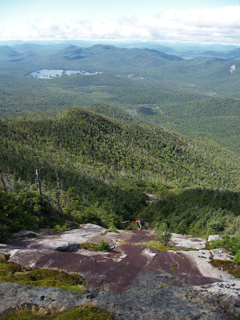
The ridge itself was a pleasant trek up a relatively open ridge with a herdpath. So pleasant it was, that I nearly reclined in the soft moss to enjoy the scenery. We were ahead of schedule as we hit the serious area of the ridgeline where elevation gain quickly adds up. A few small ledges kept it interesting. By 10:00 a.m. we were enjoying the path to the summit. A single hiker was reclining on its rocks. Five sharp-shinned hawks circled overhead riding the thermals and eying us.
South Fork Slide
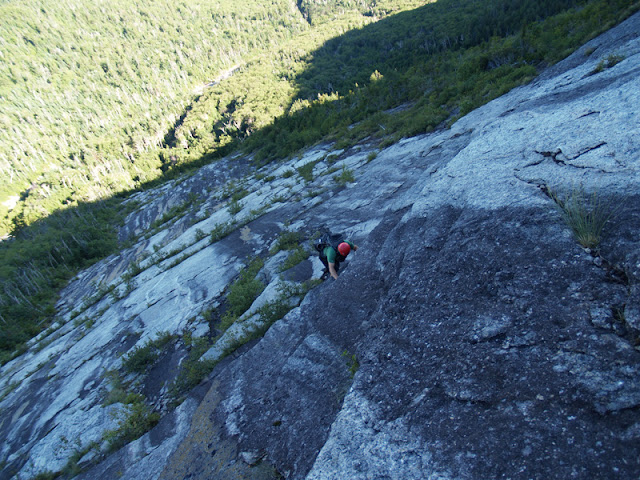
We descended back into the woods at an outcropping of rock south of the summit, this time into the gnarly krummholz on the western side that sought a pound of flesh for passage. Ledges kept us alert as we either slid, jumped or tripped our way downward for the next 20 minutes. Eventually, we emerged on the top of the middle tributary of the South Fork Slide which Rich unofficially dubbed the “Devil’s Pitchfork” some years back. The name popped to mind as I was being poked and flayed in the woods.
The slide is a nice example of rough old exposure slab and ledge sets. Wetter at the top, we descended carefully until meeting dry stone. In a short time we were at the wide confluence of the tributaries. The southern border of the slide hosted an grown in wall of boulders piled from the initial debris fall, no doubt. The true challenge awaited us below.
Descending the middle tributary of the South Fork Slide.
The initial descent down the drainage was precarious in loose rubble. It had been recently cleaned out and destabilized. The inset drainage’s steep walls hosted small sandy landslides with more rubble that threatened to break loose. Rich got ahead of me on the descent, likely because I was fiddling with my camera. I heard a yelp followed by a loud thud; my blood ran cold until I heard his voice. I literally ran down the drainage to see what happened. He was descending a pile of large boulders and placed weight on a 3 foot diameter chunk which fell below him…a reminder to both of us to test our holds and that nature is always changing.
Lower down, the rock hopping took on a different feel. Not even our hands could find decent purchase and our descent slowed. Everything was greasy and wet. I quipped that putting grease on our sneakers this morning probably wasn’t a good idea…
The ridge on either side eventually declined as we passed the confluence with the North Fork Slides (just to the north…no surprise there) at 3200’ in elevation. Below, more precipitous cascade and boulder descents, some decent blowdown and beautiful slabs and water courses led to the multi-tributary runout to the brook paralleling Hunters Pass Trail. We then went on to our third target, the 2011 West Buttress Slide. (See this report.)
Hunters Pass Slide
Refilling our water supply along the path at the brook gave us a chance to reflect upon the day. It was nearing 6:00 p.m., we hadn’t truly rested yet, but had a decent amount of climbing left either by slide or trail. Hunters Pass Slide was in our route plan, but we both held reservations regarding our remaining energy. Jim Close climbed this some years back and partway up climbed a defined dihedral with a crack along the ramp portion. The fracture disappeared at the top. He’d been curious for years if we knew the area and would venture the climb. I knew the area well as Rich called it the amphitheatre when he and I descended the slide in 2006. We’d stayed clear of the feature. This time opted to explore it out with Jim in mind (and for our own amusement as well). We threw caution to the wind, bushwhacked over to the defined drainage to the footwall and up the slide as the sun dipped near the western ridges.
Climbing is pretty laid back at first as the slope is gentle. As we approached the center of the slide and Jim’s feature, I remembered to look for a defined pool of water created by piled debris. In 2006, I found it to be very unique as it was about 8’ in diameter and 6’ deep…not something I’d yet seen in the center of a slide. It is now a mud-filled pocked with an inch or so of water in parts. Change is inevitable.
Donning rock climbing shoes at the base of what we jokingly call “Jim’s Crack” with all the associated humor one could attribute to such a name, we eyed the lines of ascent. I told Rich that I’d try to climb it, but if I felt too tired or uncomfortable, I’d be down in a heartbeat. The day was wearing on me. Staying close to the crack and wall, I climbed the ramp on rather smooth rock at times, but never felt uncomfortable. As I stated, the crack peters out at the top where the dihedral coincidentally becomes less defined; friction and some small finger/foot holds are all that are useful. I exited to the left on some minor ripples in the stone and kept my mind focused upward. I was exposed and knew I didn’t want my mind to stray. Rich came up next and made an easy climb of it, exiting directly in line with the right-leaning slope on pure friction. In the end it was a wonderful climb.
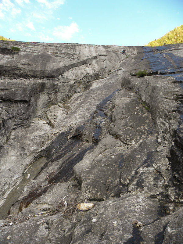
Kevin climbing the dihedral in the center of the slide...look toward the top.
Above, the slide opened into several tributaries with a new one from Irene entering on the right-hand side. Our target was to the north over the broad expanse of stone. Just before the tributary climb, the sun set and I took some 2 second exposures to capture the beauty of the moment (and catch my breath). The tributary gets ever steeper and more ledge-ridden with elevation until tapering off into the evergreens. 100’ of ascent put us on the trail. Only another 45 minutes of walking down the steep trail to our camp stood between us and dinner.
Back at the Wrist of the northern/northeastern slides, we shivered as we refilled our water at about 8:45 p.m. The temperature was again in the low 50’s as Dial’s profile silhouetted against a steel blue sky. It had been a long day of bushwhacking even though the mileage was under 6 and elevation a bit under 5000’ vertical. A lasagna dinner felt good in my belly at 9:30 while bed felt even more fulfilling by 10:30. Animals be darned, I slept well that evening.
PICTURES
On my annual 3 days of sliding and bushwhacking, I decided to play on Dix, Giant and a few other mountains. WalkWithBlackflies (Rich) and I entered via AMR Friday night, setting up camp a few hundred yards from Dix’ northern Finger Slides at around midnight. We joked all the way in, but somehow didn’t manage to awaken the horde of campers at the N. Boquet Lean-to as we passed through. I think we both intended to overnight at the site since we were tired, but that dream evaporated instantly.
Dix Ring Finger Slide
There was much animal activity during the evening culminating with a porcupine chewing its way through the area and, as Rich said, an “alarm hornet” at 6:00 a.m., curious about about what manner of creature was sleeping under a yellow sil-nylon tarp. Perhaps it was attracted to all the sap that had dripped on the tarp from the birch overnight. I had the alarm set for 6:30 a.m. anyway. We were slowly walking upward by 6:45. We ate a light breakfast on the “Wrist” area of the slide array and filled our water bladders with 3 liters of tasty mountain water. 8:00 a.m. saw us at the steep foot-wall of the center “Ring Finger”. It was still shielded from the sun by Dix’ ridge, washed in a shadow that kept the rock cold underfoot. It was in the low 50’s (F).
The climb was without drama even though we (Rich especially) took the most difficult lines toward and up any ledges en route. Especially interesting was a convex ledge with complex layering. A carpet of moss decorated the steep slab at its base, however. I remember watching Rich explore it as I climbed my own vertical, albeit shorter, portion of the ledge. The Index Finger Slide served as our backdrop, awash in the gentle early morning sun on a cloudless morning.
Rich climbing the Ring.
Open runs of stone, some a bit sandy, led to the final algae covered ledges and into the vegetation. The last time I was on this slide in autumn of 2009, I’d descended it, exploring 9 slides in total on this flank of Dix. I hadn’t checked out the ridge, however. We did. The short trees were broken by many an outcrop or erratic decorated with miniature cairns. A larger ledge a bit above the Middle Finger Slide served as an ideal spot for another breakfast of banana bread.
The ridge itself was a pleasant trek up a relatively open ridge with a herdpath. So pleasant it was, that I nearly reclined in the soft moss to enjoy the scenery. We were ahead of schedule as we hit the serious area of the ridgeline where elevation gain quickly adds up. A few small ledges kept it interesting. By 10:00 a.m. we were enjoying the path to the summit. A single hiker was reclining on its rocks. Five sharp-shinned hawks circled overhead riding the thermals and eying us.
South Fork Slide
We descended back into the woods at an outcropping of rock south of the summit, this time into the gnarly krummholz on the western side that sought a pound of flesh for passage. Ledges kept us alert as we either slid, jumped or tripped our way downward for the next 20 minutes. Eventually, we emerged on the top of the middle tributary of the South Fork Slide which Rich unofficially dubbed the “Devil’s Pitchfork” some years back. The name popped to mind as I was being poked and flayed in the woods.
The slide is a nice example of rough old exposure slab and ledge sets. Wetter at the top, we descended carefully until meeting dry stone. In a short time we were at the wide confluence of the tributaries. The southern border of the slide hosted an grown in wall of boulders piled from the initial debris fall, no doubt. The true challenge awaited us below.
Descending the middle tributary of the South Fork Slide.
The initial descent down the drainage was precarious in loose rubble. It had been recently cleaned out and destabilized. The inset drainage’s steep walls hosted small sandy landslides with more rubble that threatened to break loose. Rich got ahead of me on the descent, likely because I was fiddling with my camera. I heard a yelp followed by a loud thud; my blood ran cold until I heard his voice. I literally ran down the drainage to see what happened. He was descending a pile of large boulders and placed weight on a 3 foot diameter chunk which fell below him…a reminder to both of us to test our holds and that nature is always changing.
Lower down, the rock hopping took on a different feel. Not even our hands could find decent purchase and our descent slowed. Everything was greasy and wet. I quipped that putting grease on our sneakers this morning probably wasn’t a good idea…
The ridge on either side eventually declined as we passed the confluence with the North Fork Slides (just to the north…no surprise there) at 3200’ in elevation. Below, more precipitous cascade and boulder descents, some decent blowdown and beautiful slabs and water courses led to the multi-tributary runout to the brook paralleling Hunters Pass Trail. We then went on to our third target, the 2011 West Buttress Slide. (See this report.)
Hunters Pass Slide
Refilling our water supply along the path at the brook gave us a chance to reflect upon the day. It was nearing 6:00 p.m., we hadn’t truly rested yet, but had a decent amount of climbing left either by slide or trail. Hunters Pass Slide was in our route plan, but we both held reservations regarding our remaining energy. Jim Close climbed this some years back and partway up climbed a defined dihedral with a crack along the ramp portion. The fracture disappeared at the top. He’d been curious for years if we knew the area and would venture the climb. I knew the area well as Rich called it the amphitheatre when he and I descended the slide in 2006. We’d stayed clear of the feature. This time opted to explore it out with Jim in mind (and for our own amusement as well). We threw caution to the wind, bushwhacked over to the defined drainage to the footwall and up the slide as the sun dipped near the western ridges.
Climbing is pretty laid back at first as the slope is gentle. As we approached the center of the slide and Jim’s feature, I remembered to look for a defined pool of water created by piled debris. In 2006, I found it to be very unique as it was about 8’ in diameter and 6’ deep…not something I’d yet seen in the center of a slide. It is now a mud-filled pocked with an inch or so of water in parts. Change is inevitable.
Donning rock climbing shoes at the base of what we jokingly call “Jim’s Crack” with all the associated humor one could attribute to such a name, we eyed the lines of ascent. I told Rich that I’d try to climb it, but if I felt too tired or uncomfortable, I’d be down in a heartbeat. The day was wearing on me. Staying close to the crack and wall, I climbed the ramp on rather smooth rock at times, but never felt uncomfortable. As I stated, the crack peters out at the top where the dihedral coincidentally becomes less defined; friction and some small finger/foot holds are all that are useful. I exited to the left on some minor ripples in the stone and kept my mind focused upward. I was exposed and knew I didn’t want my mind to stray. Rich came up next and made an easy climb of it, exiting directly in line with the right-leaning slope on pure friction. In the end it was a wonderful climb.
Kevin climbing the dihedral in the center of the slide...look toward the top.
Above, the slide opened into several tributaries with a new one from Irene entering on the right-hand side. Our target was to the north over the broad expanse of stone. Just before the tributary climb, the sun set and I took some 2 second exposures to capture the beauty of the moment (and catch my breath). The tributary gets ever steeper and more ledge-ridden with elevation until tapering off into the evergreens. 100’ of ascent put us on the trail. Only another 45 minutes of walking down the steep trail to our camp stood between us and dinner.
Back at the Wrist of the northern/northeastern slides, we shivered as we refilled our water at about 8:45 p.m. The temperature was again in the low 50’s as Dial’s profile silhouetted against a steel blue sky. It had been a long day of bushwhacking even though the mileage was under 6 and elevation a bit under 5000’ vertical. A lasagna dinner felt good in my belly at 9:30 while bed felt even more fulfilling by 10:30. Animals be darned, I slept well that evening.
Last edited: