
On the last day of my trip, we headed 30 miles south to Rangeley to tag the Saddlebacks. For the whole week, the weather forecast was sketchy and every day, except possibly Tuesday (Bigelows), it was better than forecast. So I was concerned when Friday showed nice weather all week... until Friday morning when it showed mostly cloudy and I knew we were all set! Friday may have been the nicest day of July, and we were in for a treat with 5+ miles of above-treeline hiking. I knew it would be a stellar hike because it started with a moose sighting, which has always been a good omen for me.
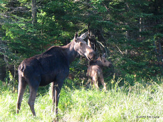
Mama and baby, Bob breaking out of the trees
We parked at the AT crossing and struck out for 7.3 miles to The Horn. The first mile is flat and wet with lots of bog bridges, mud, and roots. After Piazza Rock and the shelter, the trail climbs steeply over rocks for 650 feet or so, taking advantage of a handful of short and tight switchbacks, the kind where you can see the trail parallel to you above and below. After leveling out it passes a boggy area to the right and Ledge Pond on the left before coming to the largest pond - Eddy Pond again on the left. After the ponds, the climbing to the ridge begins and the trail becomes slab after slab until it's just one big rock and the trees disappear.
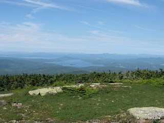
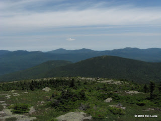
View toward Rangeley Lake, Tim on Saddleback
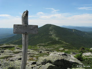
When first out of the trees, the lake views are as good as they will get. For the next 3 miles or so the trail is mostly above the trees, ducking back in for only a few hundred feet at a time. There are a few false summits along the way and eventually you can see the sign and know that the real summit is coming. Once there, the views are 360 but because it is dome-shaped, you should scramble around the perimeter for the best views. We ate and switched to a dry shirt at a windbreak just off the summit.
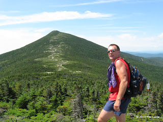
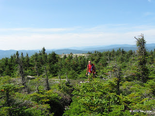
En route to The Horn, Bob with Saddleback
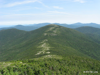
On the way to The Horn, you first cross a minor bump, which gives the illusion that The Horn is closer than it actually is. Once on and over this hump, it looks a lot further. The elevation change to the col is about 500 feet which was refreshing after the Abraham-Spauling col change of over 1000. The views keep coming the entire way across and from The Horn itself, the previous three days efforts are all visible (even the Bigelows, just barely.)
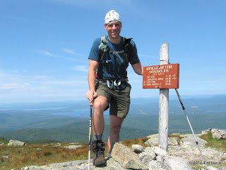
Crockers, Redington, Sugarloaf, Spaulding, Abraham and Saddleback Junior (front), Saddleback from The Horn
After another fine break for some views and food, we returned the way we came, stopping only briefly to talk to a through-hiker on Saddleback. He'd done a lot of the trail work up in this area, and worked against the Redington wind farm project. Incidentally, you can see the wind farm across Flagstaff Lake from Saddleback, as well as from on the Bigelows. At first glance, it looks like many perfectly skinny parallel slides and then you realize they aren't natural and then the turbine blades become visible. Might want to bring binoculars if that sort of thing interests you.
We completed the 14.4 mile trek in 7:15, and then began the long drives home. I'd like to once again thank Bob for driving the logging roads in the Hayesmobile.
All Photos
Tim
Mama and baby, Bob breaking out of the trees
We parked at the AT crossing and struck out for 7.3 miles to The Horn. The first mile is flat and wet with lots of bog bridges, mud, and roots. After Piazza Rock and the shelter, the trail climbs steeply over rocks for 650 feet or so, taking advantage of a handful of short and tight switchbacks, the kind where you can see the trail parallel to you above and below. After leveling out it passes a boggy area to the right and Ledge Pond on the left before coming to the largest pond - Eddy Pond again on the left. After the ponds, the climbing to the ridge begins and the trail becomes slab after slab until it's just one big rock and the trees disappear.
View toward Rangeley Lake, Tim on Saddleback
When first out of the trees, the lake views are as good as they will get. For the next 3 miles or so the trail is mostly above the trees, ducking back in for only a few hundred feet at a time. There are a few false summits along the way and eventually you can see the sign and know that the real summit is coming. Once there, the views are 360 but because it is dome-shaped, you should scramble around the perimeter for the best views. We ate and switched to a dry shirt at a windbreak just off the summit.
En route to The Horn, Bob with Saddleback
On the way to The Horn, you first cross a minor bump, which gives the illusion that The Horn is closer than it actually is. Once on and over this hump, it looks a lot further. The elevation change to the col is about 500 feet which was refreshing after the Abraham-Spauling col change of over 1000. The views keep coming the entire way across and from The Horn itself, the previous three days efforts are all visible (even the Bigelows, just barely.)
Crockers, Redington, Sugarloaf, Spaulding, Abraham and Saddleback Junior (front), Saddleback from The Horn
After another fine break for some views and food, we returned the way we came, stopping only briefly to talk to a through-hiker on Saddleback. He'd done a lot of the trail work up in this area, and worked against the Redington wind farm project. Incidentally, you can see the wind farm across Flagstaff Lake from Saddleback, as well as from on the Bigelows. At first glance, it looks like many perfectly skinny parallel slides and then you realize they aren't natural and then the turbine blades become visible. Might want to bring binoculars if that sort of thing interests you.
We completed the 14.4 mile trek in 7:15, and then began the long drives home. I'd like to once again thank Bob for driving the logging roads in the Hayesmobile.
All Photos
Tim
")