
I advertised this trip here and along with Roberta and Whitney, we got Scarpy, Dehydrator and Stinkyfeet. We had options in case the nor'easter had made thing impassable, or more likely, imparkable (not a word, I know). We met at the Whitehouse trailhead which was plowed out enough to fit many cars, although we were the only ones there at 6:30am. After introductions and a review of the weather forecast, we decided to proceed with the full traverse. Heading north on the parkway in two vehicles, we were immediately halted for a 15-minute delay while a flatbed hauled a car out of the median ditch. Even with the delay, we were underway by 7:30 and the first ones to head up the Old Bridle Path. It's exceedingly rare to have the 'privilege' of breaking this trail out, but we did so, in large part thanks to Dehydrator.
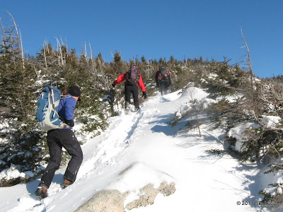
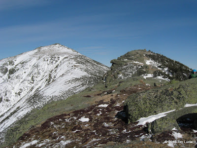
Reaching the second "Agony"; View towards Moosilauke, Lonesome Lake and the Kinsmans from "The Agonies"
Above The Agonies, we started noticing fresh bobcat tracks crisscrossing the trail. There were occasional rabbit tracks as well, but no signs of breakfast being served. Amazing that in such light power, the cat did not sink more than 1/2 an inch. Somewhere towards the top of The Agonies, Pam and Steve came blazing up behind us. After they thanked us for doing all the work, we politely stepped aside and allowed them the privilege. We saw them again briefly at the hut where we geared up and refueled for the cold and windy stretch. The wind was more northerly than northwesterly making it more of a cross wind than on my back left shoulder. Forecast said low single digits with 40-55mph above 5000 feet, and I would buy 40+, not enough to blow my feet around. MWO says 50 while were between the hut and the summit, but that is another 1000 feet higher.
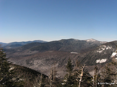
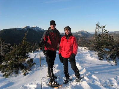
From Lafayette, surveying Garfield, the Pemigewasset Wilderness and Presidential Range; The group ascending North Lincoln
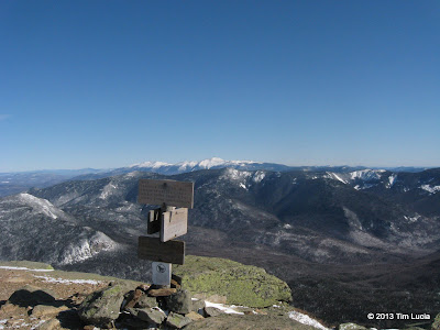
After a quick summit photo or two, we dropped down to the southeast and ... out of the wind. Sitting in the sun, it was actually comfortable. Here we removed our snowshoes and went with microspikes, but if you were careful, the ridge was bare-bootable through Little Haystack. Where there was ice, it was level. There were several short section where post-holing was a given (thigh-deep in a few spots) but it was probably 5% of the trail. We did run into people doing the loop in reverse here and they too were either 'spiking it or bare-booting. North Lincoln was next, but we didn't stop.
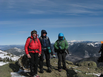
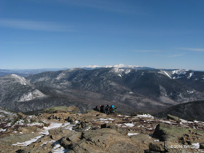
Lafayette / North Lincoln; Roberta, Sue and Whitney on Lincoln
On Lincoln, we met up with some more people and took some more pictures. It was still windy, but not as bad a Lafayette. With no shelter, we continued on to Little Haystack. This stretch in particular could have been bare-booted. At Little Haystack, we debated going down Falling Waters versus continuing with the planned traverse. The group decided to continue on to at least Liberty / Liberty Springs before deciding. As many of you know, the Franconia Ridge Trail doesn't see a lot of traffic in winter, but Scarpy is the maintainer and wanted to see it. He "warned" us up front it needed brushing, and we did end up a bit off to the right a few times where the corridor is not well-defined. I had been through in September and don't remember any problems. What we did find in this stretch is all the snow that had been missing since Greenleaf Hut") Scarpy led the first steep downhill section and both of us were sinking 2-3 feet in snowshoes. Once it leveled off, it was more of 18-24" depth with occasional deeper drifts. Sue broke trail next and I took the uphill slog to the forest protection zone where dehydrator took over for the last bit. At Liberty Springs, we decided with the mutual consent of all that Whitney, Scarpy and Dehydrator would tag Liberty and head down and Tim, Sue and Roberta would do the out-and-back to Flume. I didn't take my camera out for Liberty, although someone did (feel free to post pictures from there.)
Scarpy led the first steep downhill section and both of us were sinking 2-3 feet in snowshoes. Once it leveled off, it was more of 18-24" depth with occasional deeper drifts. Sue broke trail next and I took the uphill slog to the forest protection zone where dehydrator took over for the last bit. At Liberty Springs, we decided with the mutual consent of all that Whitney, Scarpy and Dehydrator would tag Liberty and head down and Tim, Sue and Roberta would do the out-and-back to Flume. I didn't take my camera out for Liberty, although someone did (feel free to post pictures from there.)
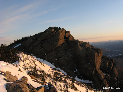
Tim and Roberta on Flume; Liberty just before sunset
From Liberty Springs to Flume was already broken out, and despite some tired legs, we were able to hoof it at a reasonable pace. Flume was nearly calm and the sun was sinking low on the horizon. It would be a headlamp hike out which was fine with all of us. The return to Liberty was fine, but the 600+ feet to the cone was a bit of a strain. We used the shortcut around the cone to avoid the steep, rocky section and came out just to the north of the sheer face. While we were later than planned, and close to sunset, I didn't want to ask to hang to watch - it was still 30 minutes away - so down we went, enjoying the sparks of orange dotting the trail in the woods. At the spring (which had water at the bottom under the snow), we dug out headlamps, but didn't need them for yet another half hour. The final 1.5 hours were done with headlamps, however, which was nice - I don't get to use mine very often.
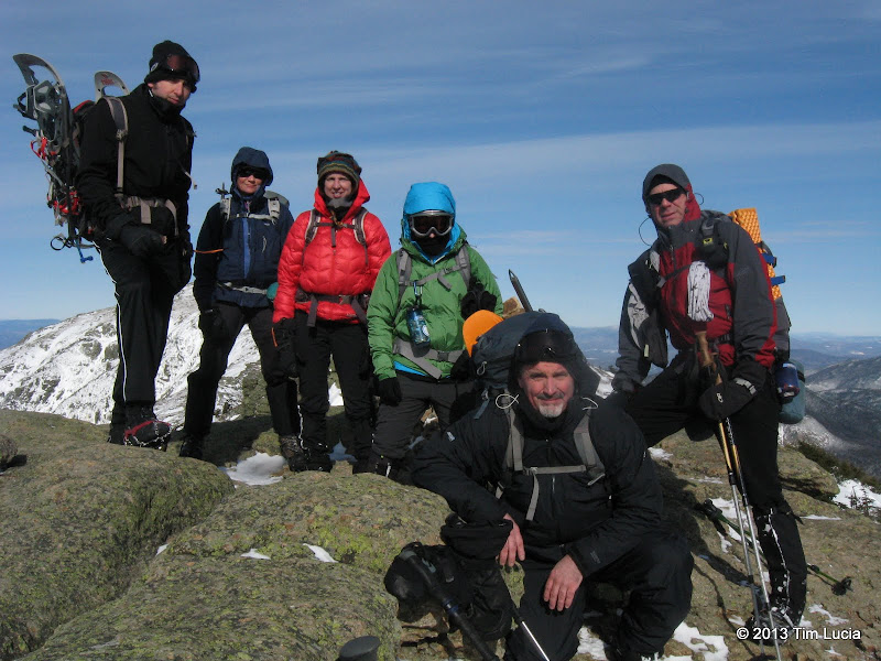
Dehydrator, Sue, Roberta, Whitney, Scarpy and Tim on Lincoln
All pictures
Tim
Reaching the second "Agony"; View towards Moosilauke, Lonesome Lake and the Kinsmans from "The Agonies"
Above The Agonies, we started noticing fresh bobcat tracks crisscrossing the trail. There were occasional rabbit tracks as well, but no signs of breakfast being served. Amazing that in such light power, the cat did not sink more than 1/2 an inch. Somewhere towards the top of The Agonies, Pam and Steve came blazing up behind us. After they thanked us for doing all the work, we politely stepped aside and allowed them the privilege. We saw them again briefly at the hut where we geared up and refueled for the cold and windy stretch. The wind was more northerly than northwesterly making it more of a cross wind than on my back left shoulder. Forecast said low single digits with 40-55mph above 5000 feet, and I would buy 40+, not enough to blow my feet around. MWO says 50 while were between the hut and the summit, but that is another 1000 feet higher.
From Lafayette, surveying Garfield, the Pemigewasset Wilderness and Presidential Range; The group ascending North Lincoln
After a quick summit photo or two, we dropped down to the southeast and ... out of the wind. Sitting in the sun, it was actually comfortable. Here we removed our snowshoes and went with microspikes, but if you were careful, the ridge was bare-bootable through Little Haystack. Where there was ice, it was level. There were several short section where post-holing was a given (thigh-deep in a few spots) but it was probably 5% of the trail. We did run into people doing the loop in reverse here and they too were either 'spiking it or bare-booting. North Lincoln was next, but we didn't stop.
Lafayette / North Lincoln; Roberta, Sue and Whitney on Lincoln
On Lincoln, we met up with some more people and took some more pictures. It was still windy, but not as bad a Lafayette. With no shelter, we continued on to Little Haystack. This stretch in particular could have been bare-booted. At Little Haystack, we debated going down Falling Waters versus continuing with the planned traverse. The group decided to continue on to at least Liberty / Liberty Springs before deciding. As many of you know, the Franconia Ridge Trail doesn't see a lot of traffic in winter, but Scarpy is the maintainer and wanted to see it. He "warned" us up front it needed brushing, and we did end up a bit off to the right a few times where the corridor is not well-defined. I had been through in September and don't remember any problems. What we did find in this stretch is all the snow that had been missing since Greenleaf Hut
Scarpy led the first steep downhill section and both of us were sinking 2-3 feet in snowshoes. Once it leveled off, it was more of 18-24" depth with occasional deeper drifts. Sue broke trail next and I took the uphill slog to the forest protection zone where dehydrator took over for the last bit. At Liberty Springs, we decided with the mutual consent of all that Whitney, Scarpy and Dehydrator would tag Liberty and head down and Tim, Sue and Roberta would do the out-and-back to Flume. I didn't take my camera out for Liberty, although someone did (feel free to post pictures from there.)
Tim and Roberta on Flume; Liberty just before sunset
From Liberty Springs to Flume was already broken out, and despite some tired legs, we were able to hoof it at a reasonable pace. Flume was nearly calm and the sun was sinking low on the horizon. It would be a headlamp hike out which was fine with all of us. The return to Liberty was fine, but the 600+ feet to the cone was a bit of a strain. We used the shortcut around the cone to avoid the steep, rocky section and came out just to the north of the sheer face. While we were later than planned, and close to sunset, I didn't want to ask to hang to watch - it was still 30 minutes away - so down we went, enjoying the sparks of orange dotting the trail in the woods. At the spring (which had water at the bottom under the snow), we dug out headlamps, but didn't need them for yet another half hour. The final 1.5 hours were done with headlamps, however, which was nice - I don't get to use mine very often.
Dehydrator, Sue, Roberta, Whitney, Scarpy and Tim on Lincoln
All pictures
Tim