
Kevin Judy and Emma
Well-known member
5/10/08
Black Snout 2803'
and Mount Shaw 2990'
7.6 Miles 2300' Elevation gain
Kevin, Judy and Emma
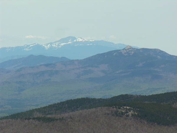
Emma had a pull or sprain on her left rear leg from a hike in Rangeley a few weeks ago. We thought she was over it, but last Friday she must have reinjured it and our plans for the weekend went undone. Over the week she improved a great deal, so we decided we'd try a medium type hike. We had been wanting to visit Mount Shaw in the Ossipee Range for quite a while. This past winter we got caught up in "Winter 48 4K Mania", so, never made it. Now seemed a perfect time. I am happy to report she was back to her old self, bounding up and down the trail, checking out every mud-puddle, and eating ravenously at the summit of Black Snout. The hike starts out on private land, along a beautiful stream called Fields Brook. There are many fine, small waterfalls here, and it ran along at a good clip as spring brooks tend to do. I would like to thank the landowner for allowing folks to hike here, it is a truly beautiful area. Further along, the trail becomes rough, and crosses into Lakes Region Conservation Trust (LRCT) land. The trail continues to follow the brook for a good way, then eventually begins a steep climb in a more easterly direction as it leaves the brook. There is about a 1/2 mile of relatively steep, but not difficult climbing until it reaches the white blazed carriage road which leads to Black Snout. This lower, southwestern shoulder of Mount Shaw affords beautiful views to the south and west across Lake Winnepesaukee to the Belknap Range and beyond. We had a beautiful, warm spring day, though it was a little hazy, and we stopped for lunch at this fine outlook. Below to the east can be seen Dan Hole Pond with the rocky summit of Mount Flagg rising above it. After lunch we returned along the carriage road and began the gentle climb to the breathtaking views to the north from Mount Shaw. While the trails so far had been littered with moose waste, the summit of Mount Shaw was dissappointingly littered with human waste. Suffice it to say that foot travel is not the only method to reach this summit in winter. Perhaps the line of thinking is, "If you don't have to expend any effort to reach a summit, you don't have to expend any effort to dispose of your trash properly," or something along those lines. I just don't know why people would flick their cigarette butts and toss their beer cans in such a beautiful place. When I see such disregard for such a beautiful place the image that was etched into all the over 40 generation's collective mind of the native American with a tear rolling down his cheek pops up in my head. Maybe this is where he was standing. When I could lift my eyes from the trash, there before me lay all of the White Mountains, from Moosilaukee in the west, to Green Mountain in the east, with Mount Washington as the centerpiece, shining like a diamond set in the middle of an emerald brooch. To say that this hike is worth the effort is grossly understating the magnifacence of the view that is to be had from this minor summit. Put it on your list of things to see before you die!
More Pictures here:
http://ghostflowers.com/white_mtns3000/blacksnoutmountshaw51008/21blacksnoutshaw51008.html
KDT