Franconia Ridge Traverse - Lafayette, Lincoln, Liberty and Flume - 2013-02-10

vftt.org

Help Support vftt.org:

This site may earn a commission from merchant affiliate links, including eBay, Amazon, and others.
From a layman's point of view as a point of comparison - air clarity in the 4 corners region of the US is about as high as anywhere in the country due to low humidity, low pollen count, etc.
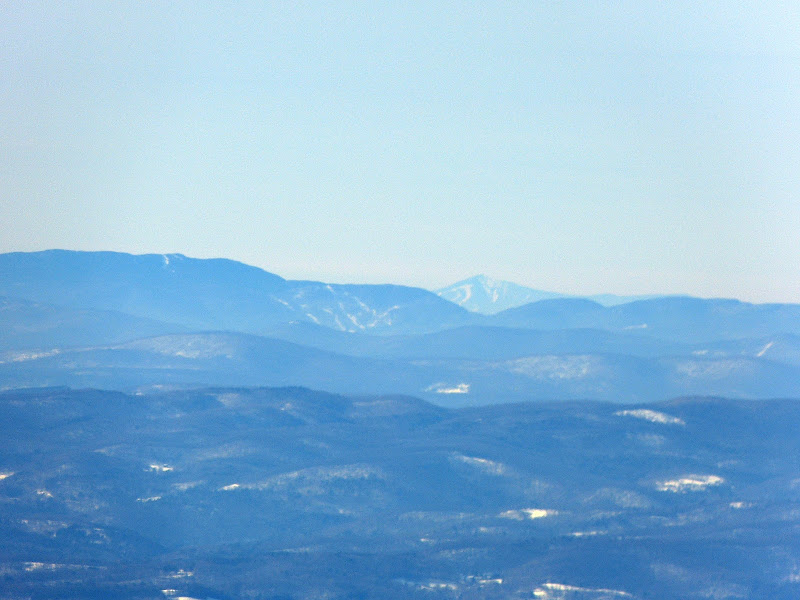
As long as the coal-fired power plants aren't running...

There must be several on this board with the technical expertise necessary - is it theoretically possible to see the ADK's from the Franconia Ridge - let's assume an elevation of 5K' - even if we discount air clarity?
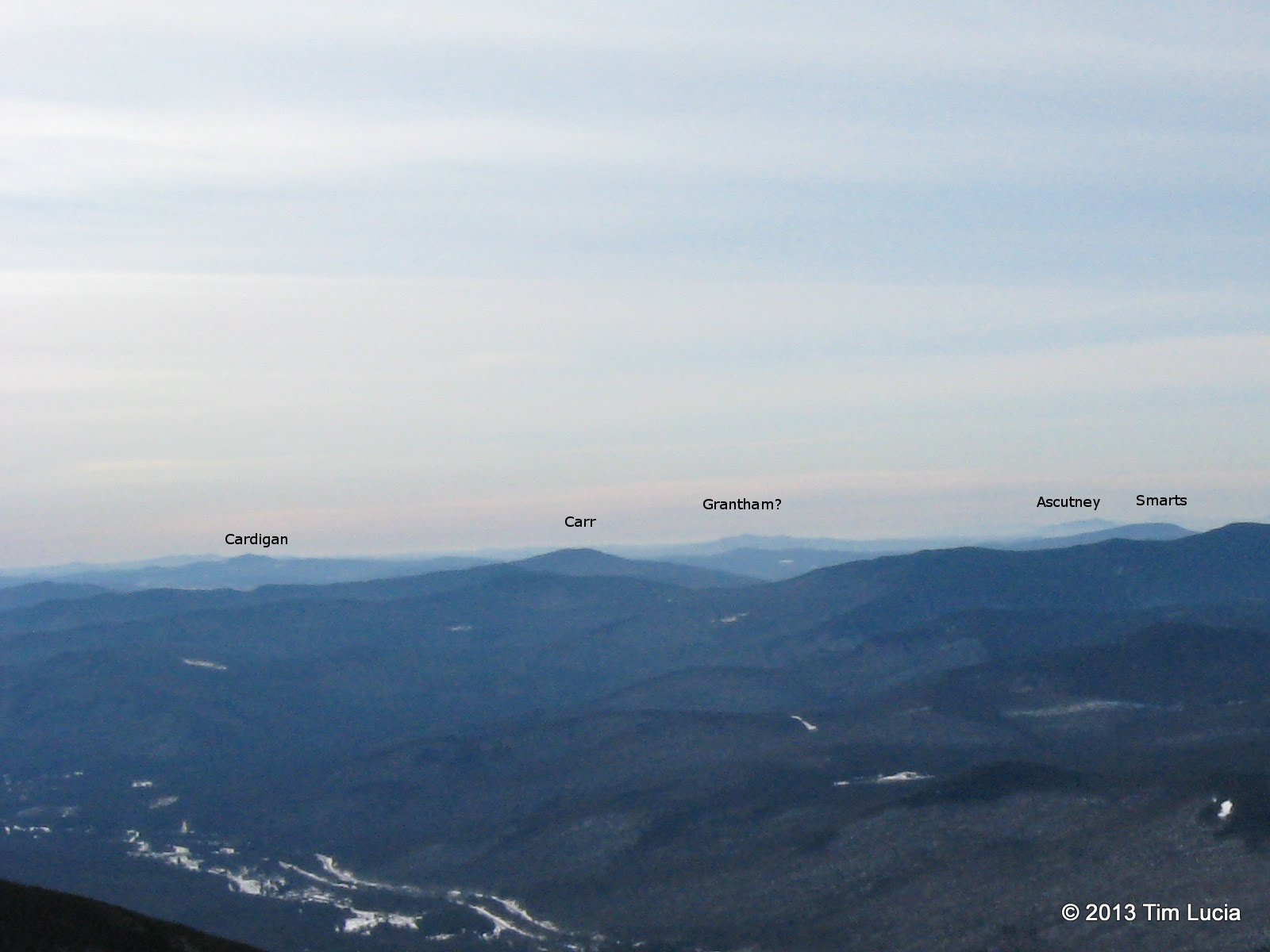
Geometrically, the horizon is:
d ~ 1.22*sqrt(h)
for d in miles, h in feet.
And if you take average atmospheric refraction into account:
d ~ 1.33*sqrt(h)
Ref: http://en.wikipedia.org/wiki/Horizon

Thus, one could see 94 miles from a 5K ft lighthouse over sea level ground and one could see another 5K ft lighthouse at twice that distance (188 mi). The real answer to whether one should be able to see the DAKs from the Whites depends on the intervening terrain.

Doug
 
Thanks, Doug. I thought you'd drop by and weigh in on this mathematical problem - this stuff is right up your alley :)
 
Well, I'm not an astronomer, but - I'd be a little skeptical of claims you could see the ADK's from the Franconia Ridge. They're about 125 miles away, and given their relatively low height, the curvature of the earth and the Green Mountain Range in between - I'm not sure they're visible.

According to Steve Smith and Mike Dickerman in The 4000-Footers book, the Daks can be seen from the high Franconias, Moosilauke, Washington and the high Presidentials, among others, on "exceptionally clear" days. I was able, through binoculars, to see Mt. Washington from Mt. Greylock, approximately 130 miles distant, on super-clear September days twice in September 2010. When I told a ranger at the Visitors Center before the second hike about the first viewing, he told me we got lucky, that there are only a few days a year in-season (when the VC, summit buildings and auto roads are open) that that is possible.

Someone told me, but I've never bothered to verify it, that the curvature of the earth becomes an issue for viewing significant objects from a high location at about 130 miles. In my own mind, I consider certain highly prominent or high elevation peaks as being in a sort of "club": they can see each other from distances where other, lower points can see neither. They each benefit from their high elevations, if you will, in the scramble to get a view of each other.

Peakbagger's assessment was shared by Chris and me: faint though they were, those were the Daks we were looking at to the west, just barely visible on an
A-visibility day. Not A+, like those days on Greylock, but close.

OOPS: Didn't see the second page posts, which mostly cover my points.
 
Last edited:
I happened to hike Moosilauke on Sunday and took this picture from the summit. This shows the Sugarbush ski area in Vermont and to the right in the distance is Mt. Whiteface in NY. I also have seen Macomb from the summit of Lafayette before. I have a picture of that also that I'll look for.

John

P1190849.JPG
 
Within the FAQs page on Mt Washingtons OBS site they say you can see Marcy and Whiteface when its clear. They also referenced the estimated limit around 130 miles as Driver8 had said.

Nice TR and Photos Tim! You guys picked one beauty of a day to be on the ridge!
 
It's becoming apparent to me that there are different definitions of "seeing" mountains in the distance. To me, it's being able to recognize by shape/distance a mountain without binoculars, telescopes, or zoom lenses on cameras or other aids with the exception of corrective lenses. But, it's equally apparent that being able to "see" a mountain means something different to others.

Vive la différence!
 
IMG_0918-001.JPG


Here is the full-size crop (1600x1200 out of the original 100% picture) I promised. I don't think I can spot Stratton. It should appear just to the right of Ascutney which is blocked by Smarts, if I am reading Google Earth properly.

Is there a different section you wanted zoomed?

Tim
 
It's becoming apparent to me that there are different definitions of "seeing" mountains in the distance. To me, it's being able to recognize by shape/distance a mountain without binoculars, telescopes, or zoom lenses on cameras or other aids with the exception of corrective lenses. But, it's equally apparent that being able to "see" a mountain means something different to others.

Vive la différence!

Just to let you know, Kevin, I could see Whiteface with my naked eye, no other aids were necessary. I could see several other peaks in the 'Daks but I couldn't name them. From Lafayette, I can also see Macomb with my naked eye on a good day. One just has to know where to look. The picture I posted was just to illustrate the point that peaks in the 'Daks can be seen from the Whites.

John
 
"but no signs of breakfast being served"

That made me laugh out loud. heh... Congrats on what sounds like an awesome day!
 
Hi Tim:

Thank for the zoom crop and labels. Between your Smarts label and Smarts itself is Stratton, hovering very faintly. Same place it's indicated at in the Peakfinder diagram of the view from Lincoln, more or less. It's quite faint but discernible in your pic and I guarantee, from experience, it was even more visible to the naked eye when you took that pic, as I have taken countless pics with cell phones and found it common that distant points, usually peaks, viewable to my naked eyes (corrected with specs, as always, alas) did not turn up in photos. I hanker for a fancy camera which will come as close as possible to capturing distant peaks that my eyes can see. Hoping to get it before too long.

PS, on edit: Here's a similar pic to yours from Flume's south summit. Left of Moosilauke is its Blue Ridge, past which appears Smarts. Left of Smarts, more faintly is Ascutney, just right of which, quite faintly, is Stratton, a bit more visible at max enlargement (in Panoramio, here: http://www.panoramio.com/photo_expl...hoto_id=83269543&order=date_desc&user=5078936) than in your pic, perhaps b/c a couple miles closer, perhaps b/c it was a bit clearer or camera had more MP or some such. And to the bespectacled eye at that time, with binocs, some of its ski trails could be seen at that time.

83269543.jpg
 
Last edited:
Top