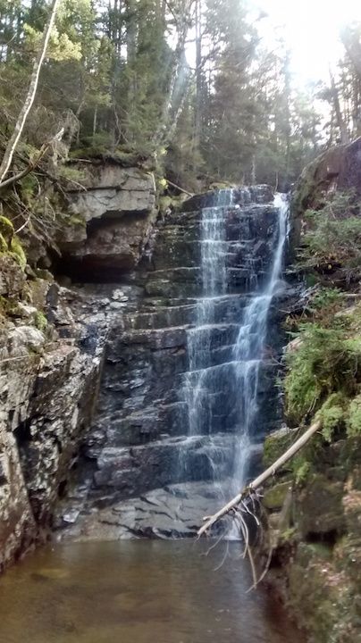
Hawthorne Falls - the perennial questions -? How/where - have they disappeared????

vftt.org

Help Support vftt.org:

This site may earn a commission from merchant affiliate links, including eBay, Amazon, and others.
You probably already did this research, Becca, but a Google search of "Hawthorne Falls New Hampshire elevation" just now gave me several quotes in the 3030'-3070' range. Looks like it might be in that flattish part where you veered east from the brook due to the blowdowns. Those references also give GPS coordinates, in case you hadn't tracked them down.
The USGS Geographic Names Information System lists Hawthorne Falls as:
Entry Date: 01-Feb-1991
Elevation: 3061ft/933m
44.1950646N 71.6009152W, NAD83

http://geonames.usgs.gov/apex/f?p=136:3:0::NO:3:P3_FID,P3_TITLE:873054,Hawthorne Falls

See also: http://mapper.acme.com/?ll=44.19506...0=44.19506,-71.60092,44.1950646N 71.6009152W

For general use:
http://geonames.usgs.gov/
http://geonames.usgs.gov/pls/gnispublic/

Note: the difference between between NAD83 and WGS84 (the default GPS datum) is only about 1 meter over much of the US so they can be considered to be equivalent for consumer GPSes.

Doug
 
Last edited:
The USGS Geographic Names Information System lists Hawthorne Falls as:
Entry Date: 01-Feb-1991
Elevation: 3061ft/933m
44.1950646N 71.6009152W, NAD83

http://geonames.usgs.gov/apex/f?p=136:3:0::NO:3:P3_FID,P3_TITLE:873054,Hawthorne Falls

See also: http://mapper.acme.com/?ll=44.19506...0=44.19506,-71.60092,44.1950646N 71.6009152W

For general use:
http://geonames.usgs.gov/
http://geonames.usgs.gov/pls/gnispublic/

Note: the difference between between NAD83 and WGS84 (the default GPS datum) is only about 1 meter over much of the US so they can be considered to be equivalent for consumer GPSes.

Doug

I saw several 3061's and a 3030-ish or two. Maybe one refers to the top and the other to the base.
 
I saw several 3061's and a 3030-ish or two. Maybe one refers to the top and the other to the base.
IIRC there is a note on the USGS site to the effect that the given location only locates one spot on extended objects.

Somehow, I suspect that if you get to either altitude, you will be close enough to find the falls...

Doug
 
Hi All! Finally found it - third time was the charm!!! Actual location was different from on the old topos and the USGS location by around a quarter mile.... I believe I was within a dozen or so yards of it the other 2 times, but, I went into the woods to avoid very thick stuff (in the past). I am pretty sure the elevation is about 2860' or so. I was expecting the Falls at a little over 3000'.

Truly unique & special area - like nothing I've ever seen before! Very much a jungle feel in there. No pics can do it justice! The rectangular pool in front of the foot of the falls also fits in the box canyon - would make an excellent swimming pool on a hot day.

This time I walked straight up the stream, only going into the woods when the cascades were too big. I wore very light traction (tiny spikes like 1/4" deep) - glad I did as it was quite icy! I did cross the stream directly above the falls to head over to Flat Top Mtn. Thanks for all your insight and inspiration fellow VFFTers!!!! :)

 
Top