1HappyHiker
Well-known member
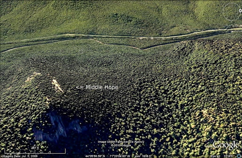
There's a branch off the Montalban Ridge called the Bemis Ridge which includes the named peaks of Mt. Crawford, Mt. Hope, Hart Ledge, and technically it also includes Cave Mountain in Bartlett. The Bemis Ridge also includes an unnamed peak (approx. 2,180 ft elev.) that is situated between Mt. Hope and Hart Ledge. Since this peak has no name, the title of this Trip Report includes some lighthearted suggestions for a name for this little guy. For the purposes of this report, I've decided to use the name Middle Hope as a way of referring to this peak.
There are no trails to what I'm calling Middle Hope, and not only that, there are no trails that are relatively close. There are several options for bushwhacking to this little mountain. I opted to begin on the Davis Path and hike less than 10 minutes to the first brook crossing. Here, I left the trail and headed southward for a couple of miles, and then headed eastward up the ridge that leads to Middle Hope.
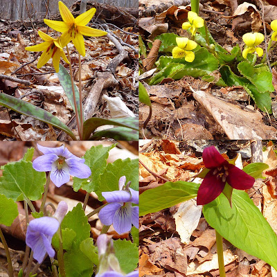
At this time of year, regardless of whether you're doing an on-trail or an off-trail hike there are lots of eye-catching things to see before you even get to your destination. I'm referring specifically to the wild flowers that are now in bloom. On my trek to Middle Hope, there were yellow violets, purple violets, trillium, and trout lily. Below is a collage of photos taken of these flowers during my trek.
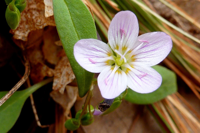
But, of all the flowers seen along the way, the one shown below was my favorite. Please correct me if I'm wrong, but I think this is called a Spring Beauty.
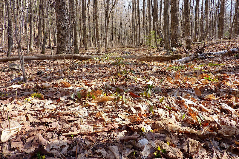
Besides enjoying the numerous wildflowers along the way, it was also very enjoyable just walking through the open woods en route to Middle Hope. The photo below shows a particularly attractive section of woods looking down a corridor of what I presume is a very old logging road.
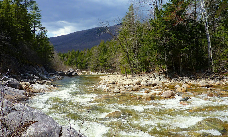
Most of my bushwhack was done well to the east of the Saco River, but at one point I decided to go down to the river bank and snap a few photos, such as the one shown below.
I eventually came to the ridge leading up to Middle Hope. Up until this point, no snow had been encountered. Thankfully, my snow-free trek continued all the way to the top of Middle Hope, except for a few isolated patches of snow here & there.
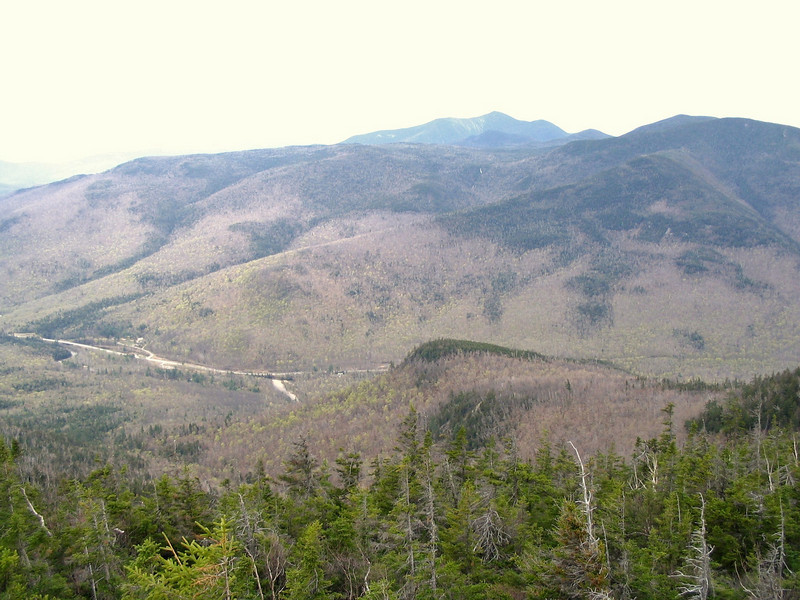
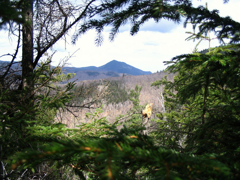
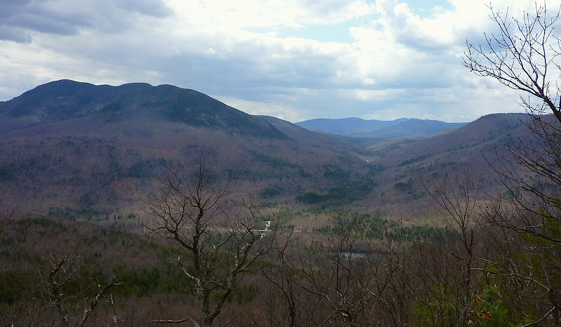
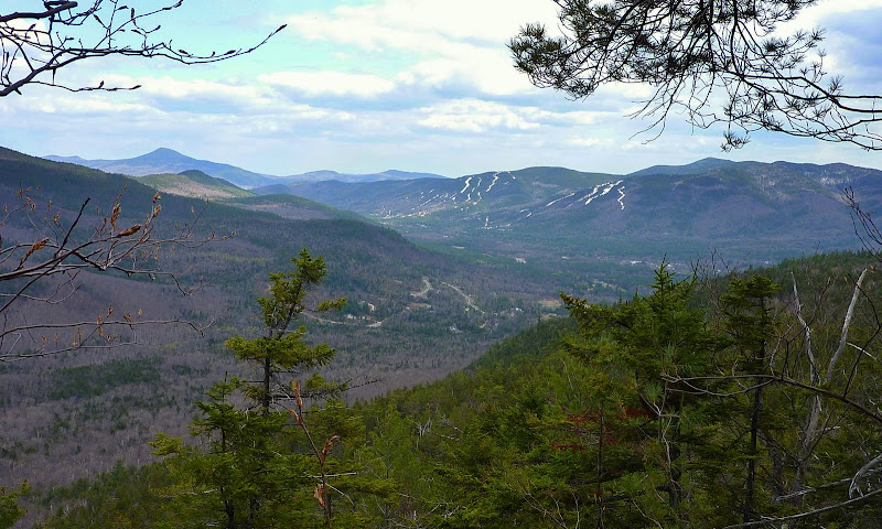
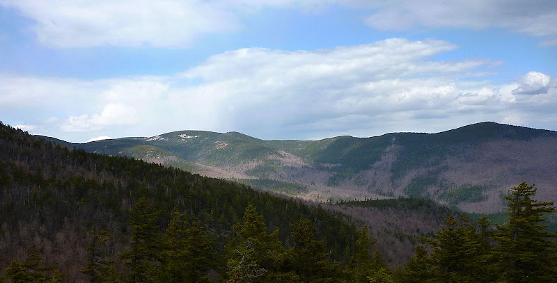
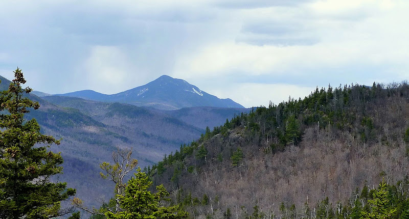
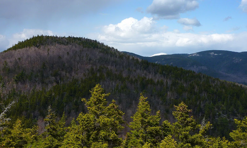
The photos below were taken from ledges on and near the summit of Middle Hope. Perhaps they will give some sense of the views from there. You'll notice that it's rather overcast and cloudy in some of these snapshots. It was supposed to be mostly sunny. It wasn't!
It wasn't supposed to rain. It did!
Sawyer River Valley with Mt Tremont on the left
A View toward Attitash
Mt. Resolution (on left) to Mt. Parker (on right)
Mt. Willey in a Rain Shower (it eventually reached me on Middle Hope)
Mt. Hope (on left) along with small tip of Mt. Washington on the horizon
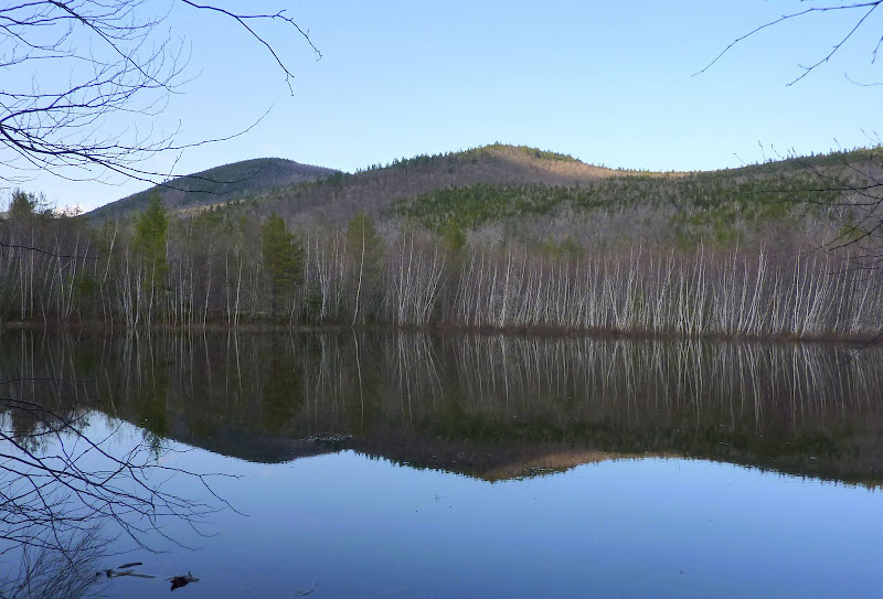
After doing this trek, I had a wee bit of time left, and so I decided to drive the short distance down to Sawyer River Road to check out something that I'd spotted on a topo map. There's a snowmobile trail on the east side of Rt. 302, directly across from the entrance to Sawyer River Road. If you follow the snowmobile trail for a few hundred feet, you cross the railroad tracks. Just slightly beyond the railroad tracks is this pond. Does anyone know anything about this body of water? Is this a naturally occurring body of water, or is it man-made?
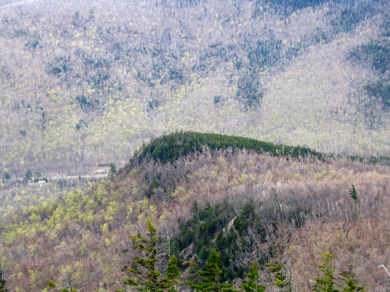
The photo below shows a portion of the pond, and also visible in this photo is Middle Hope! It's the small peak in the middle (of course") ) of the photo, and Mt. Hope is on the left. You can actually see this pond toward the bottom right of another photo (above) in this report which is labeled as: "Sawyer River Valley with Mt Tremont on the left".
) of the photo, and Mt. Hope is on the left. You can actually see this pond toward the bottom right of another photo (above) in this report which is labeled as: "Sawyer River Valley with Mt Tremont on the left".
"Mystery" Pond on east side Route 302 opposite Sawyer River Road
My trek to Middle Hope was a fun adventure. And, it marked a milestone, albeit a very minor one. I've now hiked to all the peaks along this Bemis Ridge from Cave Mountain to Mt. Crawford. However, I've not hiked the entire ridgeline that connects these peaks. And although that might be an interesting adventure, it's one that I doubt I'll ever undertake. I'm quite content with the separate stand-alone hikes I've done to each of the peaks along the Bemis Ridge.
1HappyHiker
There are no trails to what I'm calling Middle Hope, and not only that, there are no trails that are relatively close. There are several options for bushwhacking to this little mountain. I opted to begin on the Davis Path and hike less than 10 minutes to the first brook crossing. Here, I left the trail and headed southward for a couple of miles, and then headed eastward up the ridge that leads to Middle Hope.
At this time of year, regardless of whether you're doing an on-trail or an off-trail hike there are lots of eye-catching things to see before you even get to your destination. I'm referring specifically to the wild flowers that are now in bloom. On my trek to Middle Hope, there were yellow violets, purple violets, trillium, and trout lily. Below is a collage of photos taken of these flowers during my trek.
But, of all the flowers seen along the way, the one shown below was my favorite. Please correct me if I'm wrong, but I think this is called a Spring Beauty.
Besides enjoying the numerous wildflowers along the way, it was also very enjoyable just walking through the open woods en route to Middle Hope. The photo below shows a particularly attractive section of woods looking down a corridor of what I presume is a very old logging road.
Most of my bushwhack was done well to the east of the Saco River, but at one point I decided to go down to the river bank and snap a few photos, such as the one shown below.
I eventually came to the ridge leading up to Middle Hope. Up until this point, no snow had been encountered. Thankfully, my snow-free trek continued all the way to the top of Middle Hope, except for a few isolated patches of snow here & there.
The photos below were taken from ledges on and near the summit of Middle Hope. Perhaps they will give some sense of the views from there. You'll notice that it's rather overcast and cloudy in some of these snapshots. It was supposed to be mostly sunny. It wasn't!
It wasn't supposed to rain. It did!
Sawyer River Valley with Mt Tremont on the left
A View toward Attitash
Mt. Resolution (on left) to Mt. Parker (on right)
Mt. Willey in a Rain Shower (it eventually reached me on Middle Hope)
Mt. Hope (on left) along with small tip of Mt. Washington on the horizon
After doing this trek, I had a wee bit of time left, and so I decided to drive the short distance down to Sawyer River Road to check out something that I'd spotted on a topo map. There's a snowmobile trail on the east side of Rt. 302, directly across from the entrance to Sawyer River Road. If you follow the snowmobile trail for a few hundred feet, you cross the railroad tracks. Just slightly beyond the railroad tracks is this pond. Does anyone know anything about this body of water? Is this a naturally occurring body of water, or is it man-made?
The photo below shows a portion of the pond, and also visible in this photo is Middle Hope! It's the small peak in the middle (of course
) of the photo, and Mt. Hope is on the left. You can actually see this pond toward the bottom right of another photo (above) in this report which is labeled as: "Sawyer River Valley with Mt Tremont on the left"."Mystery" Pond on east side Route 302 opposite Sawyer River Road
My trek to Middle Hope was a fun adventure. And, it marked a milestone, albeit a very minor one. I've now hiked to all the peaks along this Bemis Ridge from Cave Mountain to Mt. Crawford. However, I've not hiked the entire ridgeline that connects these peaks. And although that might be an interesting adventure, it's one that I doubt I'll ever undertake. I'm quite content with the separate stand-alone hikes I've done to each of the peaks along the Bemis Ridge.
1HappyHiker
Last edited: