While doing a solo loop of North Moat on Saturday, I got turned around a bit due to a lack of blazing in the area and an error on the AMC map I was carrying. Due to the lack of blazes in the area and numerous paths and old logging roads, this is an area that does require some attention to follow the trail and could definitely be an issue to newer hikers.
Do note that the map was the "new" version (C1998), Map 3 Crawford Notch - Sandwich Range, prepared by AMC for the 26th edition (at least two WMG's old ). I probably wouldnt have posted, but later on in the day I stopped in at EMS and took a quick look at the white mountain map by Map Adventures and noticed the same error, so the error seems to have propogated. At the same time I checked the National Geographic Map and the USGS map and they show the trail correctly. The WMG guide written description accurately describes the trails correct location. It would be appreciated if someone with a newer version of the WMG, please verify if the error was corrected
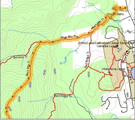
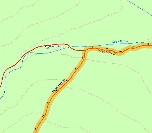
Now on with the error. From the North intersection of Red Ridge Trail and the Moat Mountain trail, the Moat Mtn trail is shown to run roughly west along the north side of Lucie Brook until it crosses the brook to the south side west of where the Mt Mtn trail heads south away from the brook. It shows the Moat Mtn trail junction with the Attitash trail on the north side of Lucie Brook with the Moat Mtn trail immediately crossing the brook. Therefore,for me using the map as a guide (the book doesnt fit in the pocket very well), I would take the turn at the Red Ridge junction and hike along the North bank until I hit the junction of the Attitash Trail. If I crossed the brook, I would have gone too far and had missed the turn off. In reality in the field, the Moat Mtn and Attitash junction is on the south side of Lucie Brook and there actually was a crossing of Lucie Brook (marked with wooden arrows) east of the junction.
What I did Saturday hike along the north side fo the brook and crossed the brook from North to South assumed that the Mt Attitash trail had continued on the north side of the brook (but was unsigned and unblazed). At that point I assumed that I was on the North Moat trail but after following the brook for about 15 to 20 minutes past the crossing, stopped looked at the map and determined that the trail didnt line up with the map and that I was on the Attitash trail and had gone far past the Moat Mtn cut off, I then and hiked back, crossed the brook and looked intently for the Moat Mtn turn off all the way to the to Red Ridge trail, which I then hiked and did the loop clockwise. Of course, coming down Moat Mtn trail I encountered the junction with the Attitash trail (with a brand new sign) on the south side of the brook and after hiking just around the corner saw where I had turned around. (what the heck I was out for exercise )
)
Considering that the new AMC maps was reputed to have been double checked with GPS and field measurements by AMC staff, it would be interesting to note how this error got introduced back in 1998 and how long it was propogated, as prior versions of the map show this correctly (although difficult to read as its on the border of the map).
So does anyone have the most recent AMC guide versions and maps to verify that this mistake was corrected? Otherwise, I will gladly officially contact the WMG editors (although I think one of the lurks here on occasion).
Do note that the map was the "new" version (C1998), Map 3 Crawford Notch - Sandwich Range, prepared by AMC for the 26th edition (at least two WMG's old ). I probably wouldnt have posted, but later on in the day I stopped in at EMS and took a quick look at the white mountain map by Map Adventures and noticed the same error, so the error seems to have propogated. At the same time I checked the National Geographic Map and the USGS map and they show the trail correctly. The WMG guide written description accurately describes the trails correct location. It would be appreciated if someone with a newer version of the WMG, please verify if the error was corrected
Now on with the error. From the North intersection of Red Ridge Trail and the Moat Mountain trail, the Moat Mtn trail is shown to run roughly west along the north side of Lucie Brook until it crosses the brook to the south side west of where the Mt Mtn trail heads south away from the brook. It shows the Moat Mtn trail junction with the Attitash trail on the north side of Lucie Brook with the Moat Mtn trail immediately crossing the brook. Therefore,for me using the map as a guide (the book doesnt fit in the pocket very well), I would take the turn at the Red Ridge junction and hike along the North bank until I hit the junction of the Attitash Trail. If I crossed the brook, I would have gone too far and had missed the turn off. In reality in the field, the Moat Mtn and Attitash junction is on the south side of Lucie Brook and there actually was a crossing of Lucie Brook (marked with wooden arrows) east of the junction.
What I did Saturday hike along the north side fo the brook and crossed the brook from North to South assumed that the Mt Attitash trail had continued on the north side of the brook (but was unsigned and unblazed). At that point I assumed that I was on the North Moat trail but after following the brook for about 15 to 20 minutes past the crossing, stopped looked at the map and determined that the trail didnt line up with the map and that I was on the Attitash trail and had gone far past the Moat Mtn cut off, I then and hiked back, crossed the brook and looked intently for the Moat Mtn turn off all the way to the to Red Ridge trail, which I then hiked and did the loop clockwise. Of course, coming down Moat Mtn trail I encountered the junction with the Attitash trail (with a brand new sign) on the south side of the brook and after hiking just around the corner saw where I had turned around. (what the heck I was out for exercise
)Considering that the new AMC maps was reputed to have been double checked with GPS and field measurements by AMC staff, it would be interesting to note how this error got introduced back in 1998 and how long it was propogated, as prior versions of the map show this correctly (although difficult to read as its on the border of the map).
So does anyone have the most recent AMC guide versions and maps to verify that this mistake was corrected? Otherwise, I will gladly officially contact the WMG editors (although I think one of the lurks here on occasion
).
Last edited: