
DSettahr
Active member
- Joined
- Apr 23, 2005
- Messages
- 981
- Reaction score
- 142
Climbed Berlin Mountain in Eastern New York yesterday with a few friends. As it turns out, Berlin Mountain is something of a "high peak" itself- at 2818 feet, it's the highest peak in NY that isn't in the Catskill or Adirondack Mountains. The peak is pretty close to the border with Massachusetts, and the Taconic Crest Trail also climbs up and over this peak.
We opted to start from the parking area for the old Williams College ski area at the end of Berlin Mountain Road, and head up the Berlin Pass trail. You can also start on Route 2 on the ridge, which involves less elevation gain but I think more distance to get to the summit. The parking area was a little bit muddy and the road to it somewhat rutted in spots, but the ground was frozen enough that we had no problems as long as we went slow. I'd probably avoid the drive up to this lot in the spring, though.
From the parking area, we followed an old road all the way up to Berlin Pass north of the peak. Easy hiking the whole way, with some washouts here and there but for the most part the trail was in good shape. The trail started in Massachusetts, but by the time we were at Berlin Pass, we were in New York!
From Berlin Pass, it was a steady climb on a woods road along the ridge to the summit. There'd been very little snow in the valley where we stared, but on the ridge it was several inches deep, and there was ice on some of the trees. It was pretty obvious that this ridge gets subjected to some pretty severe weather at times- many of the trees had poor form and weren't in the best of health.
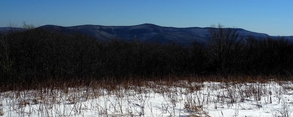
The guidebook had assured us of good views from the summit, and we weren't dissapointed. The summit is mostly bald, but not quite with a 360 degree panoramic view. We had great views to the east, with Greylock dominating the view, and the memorial on the summit clearly visible. To the south, we could see both the ski area and wind farm on Jiminy Peak. Through gaps in the trees, we could see downtown Albany to the west, the Blackhead Range and the escarpment in the Catskills to the southwest, and the Adirondack High Peaks with Iroquois/Boundary/Algonquin, Skylight, Marcy, and Haystack easy to pick out on the horizon. Being able to see both the Catskills and the Adirondacks at the same time was a real treat- I'm not sure where else you'd be able to do this (perhaps Greylock?). It makes me wonder if on a clear day you'd ever be able to see the Adirondack High Peaks from the Catskills or vice versa. I've often tried to do this, but I think maybe the central Adirondacks are too mountainous and block any potential sightings. Berlin Mountain is far enough to the east perhaps that the views of the High Peaks aren't blocked by the central Adirondacks.
After lunch on the summit, we started down through a beautiful spruce forest. Found an interesting structure just off of the summit- it looked like some kind of storage/shipping container. It had a lot of insulation on it, and almost looked like it'd been dropped from the sky...
Soon, though, we'd realized that we'd made a wrong turn- we were headed south on the Taconic Crest Trail, not east on the Class of '33 Trail, which we'd intended to take back to the trailhead. So back up to the summit we went, where we searched around for the trail east. It wasn't hard to find, but it's not immediately obvious either.
The Class of '33 trail was somewhat treacherous, due to the slippery snow at high elevations and ice at lower elevations. Microspikes would have been nice. As it was, we did get in lots of butt sliding down the mountain. Some beautiful hemlock stands along this trail as well, and nice mountain streams. According to the guidebook, there is a campsite where overnight camping is allowed somewhere along this trail, but we never saw it. It didn't take us long to reach the road at the lower trailhead, and it was an easy hike back up to the upper parking lot.
Definitely a great hike, and it was nice to try a trail someplace new for a change. The loop was about 5 miles and change, perfect distance for an easy winter hike. Some of us got so excited about the Taconic Crest Trail that we're thinking about backpacking it later this spring...
Last edited:
