
One of the benefits or living in the whites is the option on occasion to climb a local mountain without having to drive. I have done Madison and Adams in the past by walking from the house but those trips are reserved for the summer and long days. I have mixed feelings about Pine Mountain, its definitely a small mountain that pretends like its taller then it is, but the local 4, 5 and 6 thousand footers all glare down upon its summit and keep it in its place. At one time it had a fire tower which apparently gave it 360 degree views but even that small ego boost was taken away long ago. It also has a popular snow machine trail to the top which limits it attraction in the winter and the summer camp operated near the summit in the summer cuts back on its solitude. Most annoying of all is that it just happens to be tall enough and in the right location that the winter sun just below the horizon ducks behind it just at the last minute prior to sunrise during part of December and all of January to cut back on the morning sun to my office.
The time of year I normally visit is winter in February and March as my normal approach is via the north side from the former railroad station at the former Harriman Springs Bottling plant. By early February the sun is high enough to illuminate the woods on the north side and to get some warmth in the Moose River Valley, which is decidedly one of the colder spots in the area without sun. There formerly were two trails that accessed the summit from the railroad stop and I expect when the bottling plant was operating this now very quiet area was quite busy. I have seen old railroad schedules that listed stops every 1/2 hour along this railroad line that also serviced stops at Randolph East (Howker Ridge Trailhead), Appalachia, and Bowman (Castle Trailhead). The area just west of the station was an another important stop to an even older group as the area of the Moose River is a major Paleo Indian archaeological site as it was a major east west thoroughfare as the glaciers retreated.
My normal access is via a town right of way that runs south from RT 2. This route runs right by the old spring pool and comes out on the old railroad track (now a rail trail) next to the old bottling plant. From there I cross the river on the railroad bridge and then head up on the woods. I generally navigate by eye, basically heading up the slope and slowly slabbing east. The two original trails, the Straight Path and the Brook Path are long gone but the woods are open hardwoods and by staying out of the stream beds its easy going. The road to the Horton Center on top runs roughly west to east so unless you get real turned around you will hit the road and then its easy to head up hill to the Horton Center and take a right on the final trail to the summit. The Horton Center road marks a transition to dense spruce so the final leg is best by the cut hiking trail
There are actually three distinct summits on top, all worth visiting. I decided to visit the north summit today with its well situated view west and an inviting lean to. The highest summit has some open ledges that look directly at Madison, by moving around somewhat you can get different viewpoints but the rocks can be icy. There are couple of side paths that lead to viewpoints on top of the southerly ledges the final summit is Chapel Rock which can be very icy but has some great views south down Pinkham Notch and over towards Madison. The many options for camping as you roam around the summer camp apparently can be used by responsible folks but the lack of an sanitary facilities would make leave not trace a very important thing to practice. The snow machine traffic may also lead to less than quiet night.
I had just about perfect conditions today, no wind and hard crust so it was a micro spike day. The rain last week washed out the snow machine trails so rather than the constant drone of sleds it was quiet out in the woods. I did it in three hours round trip but in past years when I have had to break trail, it has been a 6 hours plus trip. Even when the snow is deep, its great hike as the slope is just about perfect for sliding.
There is also an official trail up Pine Mtn from Gorham that some use, it coincides with a major snow machine route for about 1/4 of its length so its of less interest to me. It is nice hike with varied terrain in the fall.
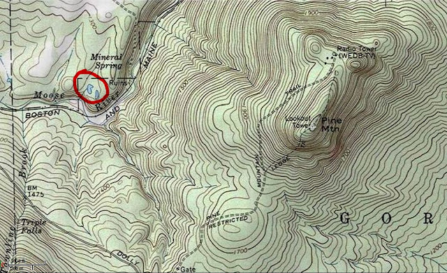
For those who want to do the hike or just visit Harriman Spring and the bottling plant, the spring is shown on most hiking maps. Harriman Spring road is primarily maintained as a driveway to a multi million dollar home with multimillion dollar view but its perfectly legal to drive right down to the power lines, park off to the side on the left and then head into the woods roughly south south east (stay to the left of the cleared area). You will soon see a metal gate and that is the continuation of the road. The road ends on a high bluff at the private campspot and then takes a sharp right slabbing down the slope to the spring pool. I am surprised in all my years that I have never seen fisherman working the pools along the Moose river.
The time of year I normally visit is winter in February and March as my normal approach is via the north side from the former railroad station at the former Harriman Springs Bottling plant. By early February the sun is high enough to illuminate the woods on the north side and to get some warmth in the Moose River Valley, which is decidedly one of the colder spots in the area without sun. There formerly were two trails that accessed the summit from the railroad stop and I expect when the bottling plant was operating this now very quiet area was quite busy. I have seen old railroad schedules that listed stops every 1/2 hour along this railroad line that also serviced stops at Randolph East (Howker Ridge Trailhead), Appalachia, and Bowman (Castle Trailhead). The area just west of the station was an another important stop to an even older group as the area of the Moose River is a major Paleo Indian archaeological site as it was a major east west thoroughfare as the glaciers retreated.
My normal access is via a town right of way that runs south from RT 2. This route runs right by the old spring pool and comes out on the old railroad track (now a rail trail) next to the old bottling plant. From there I cross the river on the railroad bridge and then head up on the woods. I generally navigate by eye, basically heading up the slope and slowly slabbing east. The two original trails, the Straight Path and the Brook Path are long gone but the woods are open hardwoods and by staying out of the stream beds its easy going. The road to the Horton Center on top runs roughly west to east so unless you get real turned around you will hit the road and then its easy to head up hill to the Horton Center and take a right on the final trail to the summit. The Horton Center road marks a transition to dense spruce so the final leg is best by the cut hiking trail
There are actually three distinct summits on top, all worth visiting. I decided to visit the north summit today with its well situated view west and an inviting lean to. The highest summit has some open ledges that look directly at Madison, by moving around somewhat you can get different viewpoints but the rocks can be icy. There are couple of side paths that lead to viewpoints on top of the southerly ledges the final summit is Chapel Rock which can be very icy but has some great views south down Pinkham Notch and over towards Madison. The many options for camping as you roam around the summer camp apparently can be used by responsible folks but the lack of an sanitary facilities would make leave not trace a very important thing to practice. The snow machine traffic may also lead to less than quiet night.
I had just about perfect conditions today, no wind and hard crust so it was a micro spike day. The rain last week washed out the snow machine trails so rather than the constant drone of sleds it was quiet out in the woods. I did it in three hours round trip but in past years when I have had to break trail, it has been a 6 hours plus trip. Even when the snow is deep, its great hike as the slope is just about perfect for sliding.
There is also an official trail up Pine Mtn from Gorham that some use, it coincides with a major snow machine route for about 1/4 of its length so its of less interest to me. It is nice hike with varied terrain in the fall.
For those who want to do the hike or just visit Harriman Spring and the bottling plant, the spring is shown on most hiking maps. Harriman Spring road is primarily maintained as a driveway to a multi million dollar home with multimillion dollar view but its perfectly legal to drive right down to the power lines, park off to the side on the left and then head into the woods roughly south south east (stay to the left of the cleared area). You will soon see a metal gate and that is the continuation of the road. The road ends on a high bluff at the private campspot and then takes a sharp right slabbing down the slope to the spring pool. I am surprised in all my years that I have never seen fisherman working the pools along the Moose river.
Last edited:
")