
Guthook
New member
- Joined
- Jan 19, 2009
- Messages
- 401
- Reaction score
- 28
I'll be putting trail reports for the New England Trail here in pieces, as quickly as I can write them. I've already got the whole gallery of photos online, and I'll be updating the day-by-day journal over time as well. For now, here is the Cohos Trail: 9/26/09 through 10/2/09.
The trail started on a frosty, foggy morning, with a drive up Routes 26 and 3 all the way to a parking pull-off right by the border crossing station. By the time Gary (aka FedEx) and I got out of Vegematic's car, the sky was clear, cold, and perfect for a walk.
Our first day was flat but beautiful. It also gave us a preview of the types of trails we would have for the next several days. First was the seemingly seldom-hiked hiking trail to Fourth Connecticut Lake, which had been carved out of the US/Canada border swath. Next was a snowmobile trail with a hiking-trail-sized swath cut through the grass. Then a walk along a dirt road, which amounted to a very pleasant walk in the woods, despite the lack of vistas. Finally, we had a long walk along the side of Route 3, a paved highway.
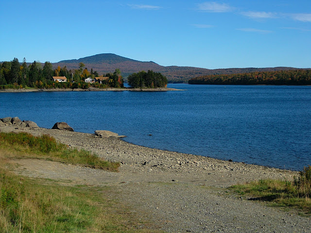
We had inadvertently timed our trip to start right at the peak of Fall foliage season, so even the least impressive views that first day were dramatic. The shores of all four Connecticut Lakes, whether seen from Route 3 or from the side of a snowmobile trail, dazzled the eyes. The monotonous road walks were saved by impressive displays of color. In the distance, Mount Magalloway towered over the region, tempting us to make a side trip for views from the fire tower.
After a long day in the sun we had a comfortable stay at the Mountain Bungalow, a hiker hostel maintained by the Cohos Trail Association and attached to the house of the CTA's president. This afforded us the opportunity to learn everything about the trail from Pete and Lainie Castine, the people who run the organization. We had a nice, long chat with them about trails, trail maintenance, relocations, and hikers.
Day two consisted entirely of dirt roads and snowmobile trails, but was also the beginning of two weeks of poor weather. We were lucky to be in the hostel for a heavy rainstorm in the night, but the first part of our day on soft, wet snowmobile trails soaked our feet in no time. This would be a common trend for the next several days. By the time we got to the shores of Lake Francis, barely two miles into the day, the thick clouds overhead had started to spit down on us. We had intermittent drizzle for the rest of the day.
Our views were considerably diminished, but we still had a pleasant walk on the eight mile Deadwater Loop Road, an old logging road that kept us in the deep woods for the entire day. The long miles of pavement from day one had taken their toll, though, and my knee was starting to hurt pretty badly-- not a good sign for the second day of the trip!
The knee pain led us to take a rest day at Rudy's Campground on the shore of Clarksville Pond. That decision was helped along by more rain and the comforts of the old cabin in which we stayed. It wasn't an exciting day by any measure, but pleasant, nonetheless.
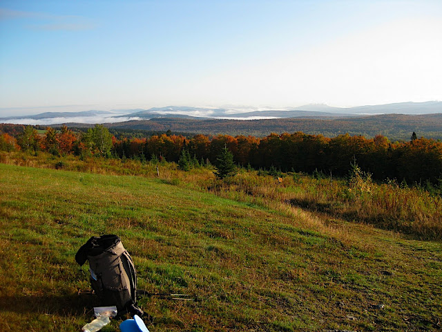
We had sunshine and mostly clear skies to start our fourth day out right. Our first view, from the top of a Christmas tree farm, showed us the mountains of the entire northern forest. We knew our luck probably wouldn't last, since we could see clouds creeping toward us, but this was at least one of our first tremendous views along the trail. Later in the morning we had another view from an interesting location: the top of a hillside dairy farm that looked south to the mountains we'd be hiking later in the day.
We took two wrong turns during the day, one giving us a beautiful view of Sanguinary Mountain, the other giving us our third and fourth moose sightings, but even without them we would not have beat the rain on our way to the shelter. Around lunch time, while we rested on the lawn at Coleman State Park, the wind picked up and the clouds started to fill the sky. A heavy cold front was on its way in, and wouldn't leave us alone for quite some time. At Panorama Lean-to, we caught the last traces of a view for which the shelter is named before the clouds covered us and a steady, cold rain began to fall.
On the morning of our fifth day we awoke in a cloud, and we never left it. Our hike into Dixville Notch, then back up to Table Rock and Dixville Peak was soggy, frigid, and mostly viewless. We did get one good look into the Notch on the way down, with its terrifyingly large cliffs, but the views that we might have had on Table Rock, Balsams' Wilderness, Dixville Peak, and the Baldhead Lean-to were nothing more than fog.
The trail started out beautifully made and maintained, since we were in a State Park, but once we left that area with its waterfalls and cliffs we had to push through various ski trails and ATV trails. We were quickly drenched, and stayed that way the entire day. With a high temperature of 35 degrees, we had to keep moving quickly to avoid hypothermia.
Day six was much the same as the day before. We awoke with ice crystals in our water bottles, and proceeded to move quickly in order to warm up. The clouds broke around noon, giving us merciful sunshine for about half an hour before moving back in and raining again. We decided to skip the side trail to 3700-foot Sugarloaf Mountain because of the clouds-- another fine view missed.
As we neared the Percy Loop Trail we saw two hunters returning to their truck. These were the only walkers we saw on the entire first week-- not a single hiker the entire time! They warned us that there would likely be snow tonight, especially at higher elevations. No surprise there-- we had noticed frost-covered trees on the side of Percy Peak earlier, and we'd had freezing temperatures for the past few nights.
Early on the morning of day seven we summited North Percy Peak. It had been another frigid night, and we awoke with the sky covered in clouds yet again. There was no view from the bald top of the mountain, but we did have a dusting of snow to entertain us. Later on in the trail, we took a side trip to Victor Head, a nice set of cliffs overlooking the town of Stark. The sky was still cloudy, but we were below the clouds at this point, so we had one of our few good views of the trail.
From Victor Head it was an easy walk to Route 110 near Stark, where we hitchhiked to Berlin, and then to Bethel for a much-needed day off. Of course, as soon as we got to Stark the skies cleared and gave us plenty of sunshine with which to dry and warm ourselves.
The Cohos Trail's northern section is a very new trail as far as long-distance trails go. The uncooperative weather and the use of ATV/snowmobile trails were all very frustrating, but as I look back on it I realize just how beautiful and challenging that trail was. For a trail that was set to close only two years ago for lack of funding and participation, this is an amazing hidden gem. The trail still gets very little use or volunteer support compared to the higher-profile mountains to the south, but hopefully it will continue to improve from year to year. An area this beautiful deserves the finest hiking trails imaginable.
The trail started on a frosty, foggy morning, with a drive up Routes 26 and 3 all the way to a parking pull-off right by the border crossing station. By the time Gary (aka FedEx) and I got out of Vegematic's car, the sky was clear, cold, and perfect for a walk.
Our first day was flat but beautiful. It also gave us a preview of the types of trails we would have for the next several days. First was the seemingly seldom-hiked hiking trail to Fourth Connecticut Lake, which had been carved out of the US/Canada border swath. Next was a snowmobile trail with a hiking-trail-sized swath cut through the grass. Then a walk along a dirt road, which amounted to a very pleasant walk in the woods, despite the lack of vistas. Finally, we had a long walk along the side of Route 3, a paved highway.
We had inadvertently timed our trip to start right at the peak of Fall foliage season, so even the least impressive views that first day were dramatic. The shores of all four Connecticut Lakes, whether seen from Route 3 or from the side of a snowmobile trail, dazzled the eyes. The monotonous road walks were saved by impressive displays of color. In the distance, Mount Magalloway towered over the region, tempting us to make a side trip for views from the fire tower.
After a long day in the sun we had a comfortable stay at the Mountain Bungalow, a hiker hostel maintained by the Cohos Trail Association and attached to the house of the CTA's president. This afforded us the opportunity to learn everything about the trail from Pete and Lainie Castine, the people who run the organization. We had a nice, long chat with them about trails, trail maintenance, relocations, and hikers.
Day two consisted entirely of dirt roads and snowmobile trails, but was also the beginning of two weeks of poor weather. We were lucky to be in the hostel for a heavy rainstorm in the night, but the first part of our day on soft, wet snowmobile trails soaked our feet in no time. This would be a common trend for the next several days. By the time we got to the shores of Lake Francis, barely two miles into the day, the thick clouds overhead had started to spit down on us. We had intermittent drizzle for the rest of the day.
Our views were considerably diminished, but we still had a pleasant walk on the eight mile Deadwater Loop Road, an old logging road that kept us in the deep woods for the entire day. The long miles of pavement from day one had taken their toll, though, and my knee was starting to hurt pretty badly-- not a good sign for the second day of the trip!
The knee pain led us to take a rest day at Rudy's Campground on the shore of Clarksville Pond. That decision was helped along by more rain and the comforts of the old cabin in which we stayed. It wasn't an exciting day by any measure, but pleasant, nonetheless.
We had sunshine and mostly clear skies to start our fourth day out right. Our first view, from the top of a Christmas tree farm, showed us the mountains of the entire northern forest. We knew our luck probably wouldn't last, since we could see clouds creeping toward us, but this was at least one of our first tremendous views along the trail. Later in the morning we had another view from an interesting location: the top of a hillside dairy farm that looked south to the mountains we'd be hiking later in the day.
We took two wrong turns during the day, one giving us a beautiful view of Sanguinary Mountain, the other giving us our third and fourth moose sightings, but even without them we would not have beat the rain on our way to the shelter. Around lunch time, while we rested on the lawn at Coleman State Park, the wind picked up and the clouds started to fill the sky. A heavy cold front was on its way in, and wouldn't leave us alone for quite some time. At Panorama Lean-to, we caught the last traces of a view for which the shelter is named before the clouds covered us and a steady, cold rain began to fall.
On the morning of our fifth day we awoke in a cloud, and we never left it. Our hike into Dixville Notch, then back up to Table Rock and Dixville Peak was soggy, frigid, and mostly viewless. We did get one good look into the Notch on the way down, with its terrifyingly large cliffs, but the views that we might have had on Table Rock, Balsams' Wilderness, Dixville Peak, and the Baldhead Lean-to were nothing more than fog.
The trail started out beautifully made and maintained, since we were in a State Park, but once we left that area with its waterfalls and cliffs we had to push through various ski trails and ATV trails. We were quickly drenched, and stayed that way the entire day. With a high temperature of 35 degrees, we had to keep moving quickly to avoid hypothermia.
Day six was much the same as the day before. We awoke with ice crystals in our water bottles, and proceeded to move quickly in order to warm up. The clouds broke around noon, giving us merciful sunshine for about half an hour before moving back in and raining again. We decided to skip the side trail to 3700-foot Sugarloaf Mountain because of the clouds-- another fine view missed.
As we neared the Percy Loop Trail we saw two hunters returning to their truck. These were the only walkers we saw on the entire first week-- not a single hiker the entire time! They warned us that there would likely be snow tonight, especially at higher elevations. No surprise there-- we had noticed frost-covered trees on the side of Percy Peak earlier, and we'd had freezing temperatures for the past few nights.
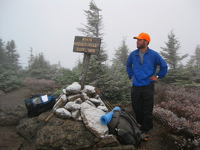
Early on the morning of day seven we summited North Percy Peak. It had been another frigid night, and we awoke with the sky covered in clouds yet again. There was no view from the bald top of the mountain, but we did have a dusting of snow to entertain us. Later on in the trail, we took a side trip to Victor Head, a nice set of cliffs overlooking the town of Stark. The sky was still cloudy, but we were below the clouds at this point, so we had one of our few good views of the trail.
From Victor Head it was an easy walk to Route 110 near Stark, where we hitchhiked to Berlin, and then to Bethel for a much-needed day off. Of course, as soon as we got to Stark the skies cleared and gave us plenty of sunshine with which to dry and warm ourselves.
The Cohos Trail's northern section is a very new trail as far as long-distance trails go. The uncooperative weather and the use of ATV/snowmobile trails were all very frustrating, but as I look back on it I realize just how beautiful and challenging that trail was. For a trail that was set to close only two years ago for lack of funding and participation, this is an amazing hidden gem. The trail still gets very little use or volunteer support compared to the higher-profile mountains to the south, but hopefully it will continue to improve from year to year. An area this beautiful deserves the finest hiking trails imaginable.
") Nice report! Looks like a cool beginning to your adventure!
Nice report! Looks like a cool beginning to your adventure!