
Three short trip reports combined into one thread...
Pico
16-June-2011
Pico Peak (3957) [75/100] Sherburne Trail, out-and-back, 5.6 miles, 1900 feet, 3:00
On Christmas Eve last year, a group of us attempted Mendon, Killington and Pico but abandoned the trip to Pico due to concerns about trail conditions and the lack of daylight. Coming up from Sherburne Pass (elevation 2150) made Pico one of the easiest peaks on the Hundred Highest. Many co-workers are on vacation this week and so it was a convenient time to use a vacation day. The drive was beautiful and of course the radio was a buzz with the Bruin's Stanley Cup win!
The Sherburne Trail is reasonably gentle with a few steeper sections. Since it is adjacent to and actually intersects various ski trails (and/or maintenance roads), you need to watch for blazes. The first intersection overlooks Sherburne Pass, and you turn left up the ski trail for a hundred feet or so prior to returning to the woods. Note that this route becomes level for maybe half a mile and then goes up to the summit. You could continue up the trail further until it intersects with a maintenance road (which may be skiable) which itself heads over to Killington. Assuming the trail is groomed and they allow hikers on it, winter travel might be easier on the ski trail.
Below 3000' or so, the wildflowers seem to be gone, or at least all the early ones. Plenty of trillium plants, but no flowers. Above 3000', the late bloomers are showing with bunchberry, star flowers and bluebead lillies. These are probably the most common alpine wildflowers there are in the forest (not counting above-treeline.) Stopping for more than a few seconds allowed the black flies and deer flies to catch up, so I kept moving. At the old shelter I turned right to follow the trail to the summit, where the trail became steeper and narrower.
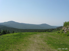
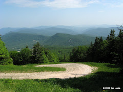
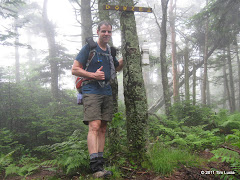
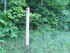
Half-way between the shelter and the summit, the trail crosses a maintenance road/ski trail. There doesn't appear to be lift access to this trail, except if you want to ski up it for a while. The maps show it going down towards Killington's base. Anyway, the trail goes straight across before topping out near the summit lift. Behind the ski patrol shed is the actual summit, marked with a blue square, and snow-making pipes. I puttered around for a bit but the bugs were bad and the views almost always included communication towers. Two guys in a pickup had driven up to work on the equipment, so clearly there is a decent road ascent if that is to your liking.
All Photos
Dorset
26-June-2011
Dorset (3770) [76/100] , 6.8 miles, 2350 feet, 2:45
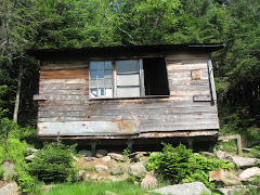
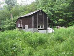
A very humid day was in store, but it was a day without anything else on the calendar. Knowing that it would be a viewless day, especially in the morning, I headed west to tag Dorset Peak, just north of Manchester, VT. Dorset is not really a "hiking destination". It is more popular with snowmobilers and the trail system is more like a series of Jeep roads then hiking trails. It was wet and muddy and I was the only car/hiker there for the day. The few stream crossings were minor and easy enough to rock hop. If you had an older or smaller Jeep / SUV, you could drive quite a ways up the trail - maybe even to this winter cabin - there were several spots along the way where you could pull off and be out of the way.
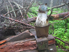
The trail goes around to the back side of the mountain and then splits. The less steep way is to stay left (north) and then make the u-turn back to the summit, which is what I did. Coming down from south peak (where the fire tower remains are) is steep but short, and rather slippery as there is not really a footbed and it was wet and very green. The cannister (and sign) were right in the middle of the trail so there is no chance of missing them. Also at the summit are the remains of some former cabin, and a water pitcher and a pail or two.
Given the nature of the trail system, this would appear to be an excellent winter peak to bring skis on, although you'd have packed conditions from (and have to be careful of) the snowmobiles.
All Photos
Equinox
26-June-2011
Equinox (3840) [77/100] , 6.2 miles, 2850 feet, 3:00
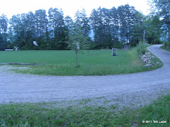
Given the close proximity to Dorset (a mere 12 miles away), and the length of the total round-trip drive (nearly 6 hours), it made sense to tackle a second peak today. The NEHH directions, and various other sources, indicate the general area from which one leaves to hike to the summit of Equinox. The key is to find either West Union Street (off Seminary Ave), or the Burr and Burton Academy. I parked at the back edge of the The Equinox Golf Resort and Spa near the playground set, got a nice (but not waterproof) map from The Equinox Preservation Trust, and followed the map there (a big map is available at the kiosk as well) to the back of the lacrosse field at Burr and Burton Academy. Above and behind that field, at the close end, is the beginning of the blue-blazed "summit trail". Note that the kiosk rates this as double-black diamond and "if you have all day".
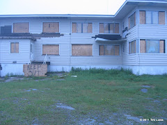
After 15 minutes or so, all of the preserve's recreational trails are behind you and it's a steady uphill grind on an old Jeep road. The footing is good and so it is possible to make great time in this section. Right where the road basically ends, on the lip of a ravine, the blue trail becomes a hiking trail after splitting off to the right, and goes up and around the top of the ravine. In fall there would be good views here but the leaves are too full in June. After grinding for a while, the grade eases and the trail passes by a tower of some sort. Go around the tower and to the right and turn left to ascend to the actual summit. The trail dumps out in the backyard of the now-closed Equinox Inn. Walking around to the front / parking lot, I found some heavy equipment suggesting that heavy remodeling, if not demolition, is soon to occur.
After chatting a while with a couple about their planned trip to the Whites, I turned around and retraced my steps out.
Note: Equinox Preservation Trust maintains the maps and kiosk. The maps are online at their web site.
All Photos
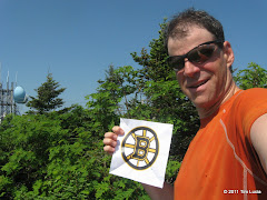
Tim
Pico
16-June-2011
Pico Peak (3957) [75/100] Sherburne Trail, out-and-back, 5.6 miles, 1900 feet, 3:00
On Christmas Eve last year, a group of us attempted Mendon, Killington and Pico but abandoned the trip to Pico due to concerns about trail conditions and the lack of daylight. Coming up from Sherburne Pass (elevation 2150) made Pico one of the easiest peaks on the Hundred Highest. Many co-workers are on vacation this week and so it was a convenient time to use a vacation day. The drive was beautiful and of course the radio was a buzz with the Bruin's Stanley Cup win!
The Sherburne Trail is reasonably gentle with a few steeper sections. Since it is adjacent to and actually intersects various ski trails (and/or maintenance roads), you need to watch for blazes. The first intersection overlooks Sherburne Pass, and you turn left up the ski trail for a hundred feet or so prior to returning to the woods. Note that this route becomes level for maybe half a mile and then goes up to the summit. You could continue up the trail further until it intersects with a maintenance road (which may be skiable) which itself heads over to Killington. Assuming the trail is groomed and they allow hikers on it, winter travel might be easier on the ski trail.
Below 3000' or so, the wildflowers seem to be gone, or at least all the early ones. Plenty of trillium plants, but no flowers. Above 3000', the late bloomers are showing with bunchberry, star flowers and bluebead lillies. These are probably the most common alpine wildflowers there are in the forest (not counting above-treeline.) Stopping for more than a few seconds allowed the black flies and deer flies to catch up, so I kept moving. At the old shelter I turned right to follow the trail to the summit, where the trail became steeper and narrower.
Half-way between the shelter and the summit, the trail crosses a maintenance road/ski trail. There doesn't appear to be lift access to this trail, except if you want to ski up it for a while. The maps show it going down towards Killington's base. Anyway, the trail goes straight across before topping out near the summit lift. Behind the ski patrol shed is the actual summit, marked with a blue square, and snow-making pipes. I puttered around for a bit but the bugs were bad and the views almost always included communication towers. Two guys in a pickup had driven up to work on the equipment, so clearly there is a decent road ascent if that is to your liking.
All Photos
Dorset
26-June-2011
Dorset (3770) [76/100] , 6.8 miles, 2350 feet, 2:45
A very humid day was in store, but it was a day without anything else on the calendar. Knowing that it would be a viewless day, especially in the morning, I headed west to tag Dorset Peak, just north of Manchester, VT. Dorset is not really a "hiking destination". It is more popular with snowmobilers and the trail system is more like a series of Jeep roads then hiking trails. It was wet and muddy and I was the only car/hiker there for the day. The few stream crossings were minor and easy enough to rock hop. If you had an older or smaller Jeep / SUV, you could drive quite a ways up the trail - maybe even to this winter cabin - there were several spots along the way where you could pull off and be out of the way.
The trail goes around to the back side of the mountain and then splits. The less steep way is to stay left (north) and then make the u-turn back to the summit, which is what I did. Coming down from south peak (where the fire tower remains are) is steep but short, and rather slippery as there is not really a footbed and it was wet and very green. The cannister (and sign) were right in the middle of the trail so there is no chance of missing them. Also at the summit are the remains of some former cabin, and a water pitcher and a pail or two.
Given the nature of the trail system, this would appear to be an excellent winter peak to bring skis on, although you'd have packed conditions from (and have to be careful of) the snowmobiles.
All Photos
Equinox
26-June-2011
Equinox (3840) [77/100] , 6.2 miles, 2850 feet, 3:00
Given the close proximity to Dorset (a mere 12 miles away), and the length of the total round-trip drive (nearly 6 hours), it made sense to tackle a second peak today. The NEHH directions, and various other sources, indicate the general area from which one leaves to hike to the summit of Equinox. The key is to find either West Union Street (off Seminary Ave), or the Burr and Burton Academy. I parked at the back edge of the The Equinox Golf Resort and Spa near the playground set, got a nice (but not waterproof) map from The Equinox Preservation Trust, and followed the map there (a big map is available at the kiosk as well) to the back of the lacrosse field at Burr and Burton Academy. Above and behind that field, at the close end, is the beginning of the blue-blazed "summit trail". Note that the kiosk rates this as double-black diamond and "if you have all day".
After 15 minutes or so, all of the preserve's recreational trails are behind you and it's a steady uphill grind on an old Jeep road. The footing is good and so it is possible to make great time in this section. Right where the road basically ends, on the lip of a ravine, the blue trail becomes a hiking trail after splitting off to the right, and goes up and around the top of the ravine. In fall there would be good views here but the leaves are too full in June. After grinding for a while, the grade eases and the trail passes by a tower of some sort. Go around the tower and to the right and turn left to ascend to the actual summit. The trail dumps out in the backyard of the now-closed Equinox Inn. Walking around to the front / parking lot, I found some heavy equipment suggesting that heavy remodeling, if not demolition, is soon to occur.
After chatting a while with a couple about their planned trip to the Whites, I turned around and retraced my steps out.
Note: Equinox Preservation Trust maintains the maps and kiosk. The maps are online at their web site.
All Photos
Tim
Last edited:
 Scott, I am at 77.