
1HappyHiker
Well-known member
It was one of those days where you could say I was looking for a ‘Goldilocks’ type of hike, i.e. something that was not too long, but not too short, and also something that didn’t involve a lot of driving. It had been awhile since I had visited the Galehead Hut so this seemed to fit my very arbitrary ‘Goldilocks’ criteria. For certain, it did not involve a lot of driving since the Gale River trailhead is only about 10 minutes from my home in Bethlehem!
Before setting out on this totally unplanned hike, I did a quick check of GoogleEarth to see if there might be some ledges somewhere nearby that I’d failed to notice on previous trips to the hut. (I’m always up for an off-trail adventure.") ) Nothing really popped out immediately, but upon looking a bit closer I saw something that looked promising. There was this ledge about midway between the Galehead Hut and the 13 Falls Tentsite, and it was only about 0.2 mile off the Twin Brook Trail.
) Nothing really popped out immediately, but upon looking a bit closer I saw something that looked promising. There was this ledge about midway between the Galehead Hut and the 13 Falls Tentsite, and it was only about 0.2 mile off the Twin Brook Trail.
Hmmm! This would mean going an extra 1.25 miles beyond the hut, and then bushwhacking 0.2 mile after leaving the trail. Also, getting there would mean descending a little over 800 ft, and then having to climb back up! Hmmm . . . now this was starting to push the limits of my ideal Goldilocks hike! I’d have to think about that on my trek up to the hut and then make a decision once I arrived. Well, I’d sort of forgotten how little time it takes to get to the Galehead Hut. I was up there is just over 2 hours. And so, the decision was made to “go for it”. I just whizzed by the hut without even stopping and headed directly for the Twin Brook Trail.
This was my first time on the Twin Brook Trail, and was I ever pleasantly surprised at what a nice trail this is! It’s well maintained, easy under foot, and a very gentle grade. With these conditions, it took less than 45 minutes to traverse the 1.25 miles to reach my jumping off point at 2,900 feet. Then, a 15 minute southwestward jaunt through open woods brought me to the edge of the ledge.
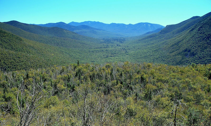
The views from this ledge are somewhat unique. You are looking squarely down the immense U-shaped Franconia Brook Valley. The bulky mass of Owl’s Head forms the western wall, and the various ridges coming off the Twin/Bond Range forms the eastern wall. Scar Ridge and the Osceolas dominate the view to the south.
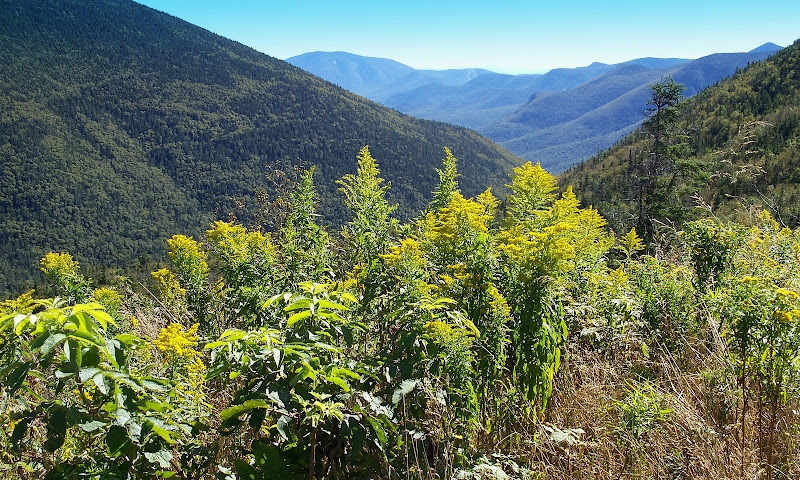
And if the valley view isn’t enough, then there is yet another eye-pleasing view to the WSW where you can look up at the rugged eastern slopes of Mts. Lafayette and Lincoln.
The 2 photos below show the views just described above. However, I don’t know if it was just the funky lighting, or if it was just me, or if it was the camera, but nonetheless, I wasn’t overly pleased with the clarity of the snapshots. Maybe I simply need to spring for a new camera!
Franconia Brook Valley
Eastern Slopes of Lafayette & Lincoln
After spending close to an hour on this sunny south facing ledge, I headed back up to the hut. Once again, with such a gentle grade on the Twin Brook Trail, the return trek took just under an hour. Unlike earlier in the day when I whizzed past the hut without stopping, I did stop for awhile this time around. I snapped a few photos, but will limit my posting to just one snapshot since nearly everyone is already familiar with the views from the hut.
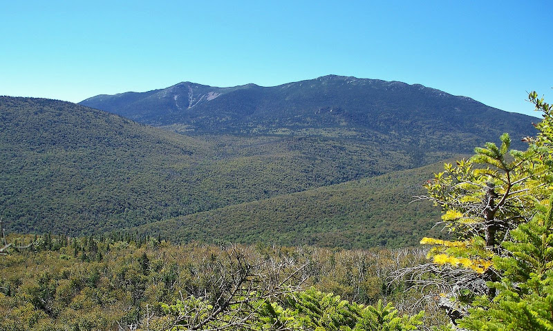
View from Galehead Hut
So there you have it. By visiting a spot that I’d never visited before, my impromptu ‘Goldilocks’ hike was made even more ‘golden’.
My little ‘add-on' made the round-trip about 3 miles longer than what I’d originally set out to do. However, it was well worth the extra mileage.
1HappyHiker
Before setting out on this totally unplanned hike, I did a quick check of GoogleEarth to see if there might be some ledges somewhere nearby that I’d failed to notice on previous trips to the hut. (I’m always up for an off-trail adventure.
) Nothing really popped out immediately, but upon looking a bit closer I saw something that looked promising. There was this ledge about midway between the Galehead Hut and the 13 Falls Tentsite, and it was only about 0.2 mile off the Twin Brook Trail. Hmmm! This would mean going an extra 1.25 miles beyond the hut, and then bushwhacking 0.2 mile after leaving the trail. Also, getting there would mean descending a little over 800 ft, and then having to climb back up! Hmmm . . . now this was starting to push the limits of my ideal Goldilocks hike! I’d have to think about that on my trek up to the hut and then make a decision once I arrived. Well, I’d sort of forgotten how little time it takes to get to the Galehead Hut. I was up there is just over 2 hours. And so, the decision was made to “go for it”. I just whizzed by the hut without even stopping and headed directly for the Twin Brook Trail.
This was my first time on the Twin Brook Trail, and was I ever pleasantly surprised at what a nice trail this is! It’s well maintained, easy under foot, and a very gentle grade. With these conditions, it took less than 45 minutes to traverse the 1.25 miles to reach my jumping off point at 2,900 feet. Then, a 15 minute southwestward jaunt through open woods brought me to the edge of the ledge.
The views from this ledge are somewhat unique. You are looking squarely down the immense U-shaped Franconia Brook Valley. The bulky mass of Owl’s Head forms the western wall, and the various ridges coming off the Twin/Bond Range forms the eastern wall. Scar Ridge and the Osceolas dominate the view to the south.
And if the valley view isn’t enough, then there is yet another eye-pleasing view to the WSW where you can look up at the rugged eastern slopes of Mts. Lafayette and Lincoln.
The 2 photos below show the views just described above. However, I don’t know if it was just the funky lighting, or if it was just me, or if it was the camera, but nonetheless, I wasn’t overly pleased with the clarity of the snapshots. Maybe I simply need to spring for a new camera!
Franconia Brook Valley
Eastern Slopes of Lafayette & Lincoln
After spending close to an hour on this sunny south facing ledge, I headed back up to the hut. Once again, with such a gentle grade on the Twin Brook Trail, the return trek took just under an hour. Unlike earlier in the day when I whizzed past the hut without stopping, I did stop for awhile this time around. I snapped a few photos, but will limit my posting to just one snapshot since nearly everyone is already familiar with the views from the hut.
View from Galehead Hut
So there you have it. By visiting a spot that I’d never visited before, my impromptu ‘Goldilocks’ hike was made even more ‘golden’.
My little ‘add-on' made the round-trip about 3 miles longer than what I’d originally set out to do. However, it was well worth the extra mileage.
1HappyHiker
Last edited: