
IQuest
New member
With the nice weather last Saturday and reading a couple recent reportsI figured it would be a good day to visit Mt Isolation. I had never used the Engine Hill bushwhack and was looking forward to it after seeing the pictures from madmattd and company's hike in December.
It would be just me and Marlie for this hike, both in persuite of winter check marks. We arrive at the Rocky Branch Tr on NH16 at 7:15, and there was already 15 cars in the lot. :shock: Of course some of them were XC skiers enjoying the freshly groomed trail that starts at the parking lot. Soon we were on the trail which was well packed and I began bare booting. After about a mile my pack was feeling extra heavy so I decided to wear the snowshoes rather than carry them. It was a good choice as the traction on packed powder was much better. I met up with a familiar face and his dog just before the trail levels off and after tailgating the three of them for a little bit I kindly asked to pass. We chatted for a brief moment and he informed me that there was a group ahead of me that that started around 5:30 that were going to break out one of the bushwhacks.
When I arrived at the "T" tree most of the track continued along the trail. I assumed that they were going to the FPA sign then whacking to the second crossing. I may check this route out next time. As I started my whack from the tree, there was one set ouf outbound snowshoe tracks and one set returning. I had studied the GPS track from Matt's report then another from Chris Daily's blog that he did in January. I had a good idea where to go and the track seemed to lead that way. I meandered up hill slightly for a while, heading north, and taking the path of least resistance. Before I new it I was in the birches or a Joe would call it "Wow Woods".
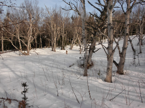
The track ran relatively level avoiding a few wet spots, I can't believe that they were not frozen after all the cold weather, and passed through acres of open birches with restricted views of Eisenhower and Monroe. At about the halfway point the track started to descend and passed trough a more traditional forest then popped out on the Isolation Tr about ten minutes below the third crossing. Overall it was much easier than I had expected. The compass stayed in the pack and I don't think I even bothered to look at the map. Of course, having 2 TRs from the past 5 days prior helped. At this point the Isolation Tr was packed in both directions but I could still see the returning snowshoe tracks that I had been following so I knew at this point no one was ahead of us.
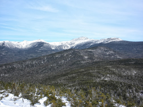
The third a fourth crossing had a few inches of powder and no tracks so I decided to stay on the east side of the river and avoid them. The fifth crossing was frozen over but running water could be heard below. We pressed on to the tentsites just before the Davis Path junction and at one of the markers we took a left through the site and cut the corner to Davis Path. It was easy going to the Mt Isolation Spur and there was no evidence of travel south along the Davos Path. We climbed the final pitch and reached the summit at about 11am. It was 23 degrees, mostly sunny, and a very light breeze. Ther views were some of the best that I've had from this peak.
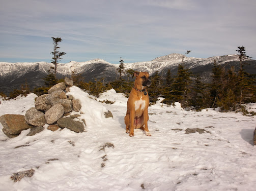
Marlie Enjoying the Views
The Rock Pile
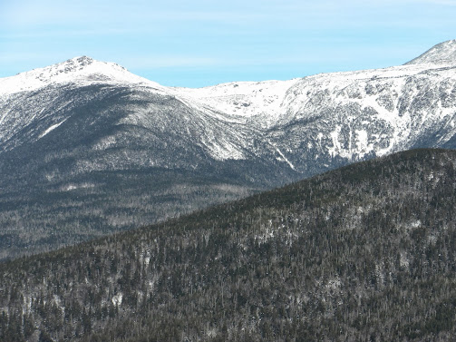
Mt Monroe and Oakes Gulf
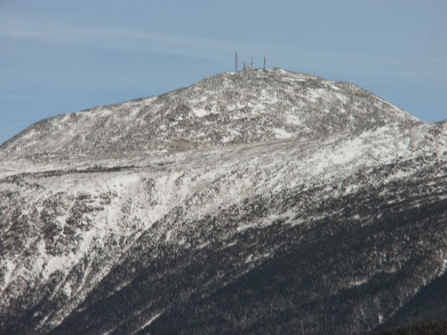
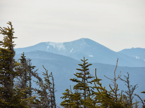
Mt Carrigain
We had the summit to ourselves for the whole time we were there and didn't meet any other hikers until past the tent sites on the Isolation Tr. On our way out I noticed that the others had made the 4th and 3rd crossing so I did as well. I would later read a report where someone had taken the trail the entire way and the crossings were all frozen. The group I had met had followed my tracks across the Engine Hill whack and that is the way that I would return. This time for views I could see Mt Carrigain in the distance and Stairs Mtn near by as well as a few other peaks. Althought the trails were well packed, it was still soft through here and would have been quite strenous with out snowshoes. I never did see the early group or the familiar face again. We made it back to my truck just before 2pm. Job well done Marlie.
The Pics: https://plus.google.com/photos/117581678131843187857/albums/5975573947834572849
NETC: http://www.newenglandtrailconditions.com/nh/viewreport.php?entryid=15378
It would be just me and Marlie for this hike, both in persuite of winter check marks. We arrive at the Rocky Branch Tr on NH16 at 7:15, and there was already 15 cars in the lot. :shock: Of course some of them were XC skiers enjoying the freshly groomed trail that starts at the parking lot. Soon we were on the trail which was well packed and I began bare booting. After about a mile my pack was feeling extra heavy so I decided to wear the snowshoes rather than carry them. It was a good choice as the traction on packed powder was much better. I met up with a familiar face and his dog just before the trail levels off and after tailgating the three of them for a little bit I kindly asked to pass. We chatted for a brief moment and he informed me that there was a group ahead of me that that started around 5:30 that were going to break out one of the bushwhacks.
When I arrived at the "T" tree most of the track continued along the trail. I assumed that they were going to the FPA sign then whacking to the second crossing. I may check this route out next time. As I started my whack from the tree, there was one set ouf outbound snowshoe tracks and one set returning. I had studied the GPS track from Matt's report then another from Chris Daily's blog that he did in January. I had a good idea where to go and the track seemed to lead that way. I meandered up hill slightly for a while, heading north, and taking the path of least resistance. Before I new it I was in the birches or a Joe would call it "Wow Woods".
The track ran relatively level avoiding a few wet spots, I can't believe that they were not frozen after all the cold weather, and passed through acres of open birches with restricted views of Eisenhower and Monroe. At about the halfway point the track started to descend and passed trough a more traditional forest then popped out on the Isolation Tr about ten minutes below the third crossing. Overall it was much easier than I had expected. The compass stayed in the pack and I don't think I even bothered to look at the map. Of course, having 2 TRs from the past 5 days prior helped.
At this point the Isolation Tr was packed in both directions but I could still see the returning snowshoe tracks that I had been following so I knew at this point no one was ahead of us.The third a fourth crossing had a few inches of powder and no tracks so I decided to stay on the east side of the river and avoid them. The fifth crossing was frozen over but running water could be heard below. We pressed on to the tentsites just before the Davis Path junction and at one of the markers we took a left through the site and cut the corner to Davis Path. It was easy going to the Mt Isolation Spur and there was no evidence of travel south along the Davos Path. We climbed the final pitch and reached the summit at about 11am. It was 23 degrees, mostly sunny, and a very light breeze. Ther views were some of the best that I've had from this peak.
Marlie Enjoying the Views
The Rock Pile
Mt Monroe and Oakes Gulf
Mt Carrigain
We had the summit to ourselves for the whole time we were there and didn't meet any other hikers until past the tent sites on the Isolation Tr. On our way out I noticed that the others had made the 4th and 3rd crossing so I did as well. I would later read a report where someone had taken the trail the entire way and the crossings were all frozen. The group I had met had followed my tracks across the Engine Hill whack and that is the way that I would return. This time for views I could see Mt Carrigain in the distance and Stairs Mtn near by as well as a few other peaks. Althought the trails were well packed, it was still soft through here and would have been quite strenous with out snowshoes. I never did see the early group or the familiar face again. We made it back to my truck just before 2pm. Job well done Marlie.
The Pics: https://plus.google.com/photos/117581678131843187857/albums/5975573947834572849
NETC: http://www.newenglandtrailconditions.com/nh/viewreport.php?entryid=15378