
Bob Kittredge
Active member
SUNDAY JUNE 24, 2012 TABLE ROCK - 0.6 miles, 600'
Up early in Gorham and on the road about 6AM, heading north for a scenic, 70 minute drive up 16 and 26 to Dixville Notch. Early fog was still burning off as I followed the Androscoggin north.
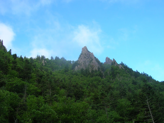
Table Rock is on TrishandAlex's Terrifying 25 list. As you approach the height of land in the Notch there is a sign warning of a Bump. Not like a speed bump; more like cresting the top of a roller coaster (whee!). The (unsigned) parking area is just on the left after this bump. The trail sign for the Table Rock Hiking Trail is a little further down. From the lot you look up and see what looks like an incredibly pointed peak, and you think, oh that can't be where I'm going. But it is.
The 0.3 mile trail is unremittingly steep from the get-go to the top. And it's all in the woods till you reach Table Rock itself. The rock's on the trail have a much smoother texture than those in the Presies. Moisture from the previous evening's rain added to the degree of difficulty. I carefully made my way up, stopping frequently to catch my breath, feel my heart pound and admire the greenery, You reach the ridge, do a short scramble and there you are, looking out on the rock which projects like a pier out into space. Although it is essentially flat and level, there are small gaps, and I found myself edging out the 40 or 50 feet to the end of the pier taking little baby steps. It narrows down to about 6 feet wide and the dropoffs are basically straight down. Down to the left is the Balsams resort, very swank. To the right a foggy view of the eastern end of the notch I had just driven up. The setting is spectacular!
The descent went fairly well except for one major slip. Fortunately, my firm grasp on a sturdy birch tree spared someone the necessity of making a sad phone call to the Widow Kittredge.
Trish, thank you so much for putting this on your list. It was well worth the drive.
By the way, I wondered about cell phone service this far north, and it occurred to me that if any place would have it, it would be the Balsams. Yep, four bars.
Click for pics.
Up early in Gorham and on the road about 6AM, heading north for a scenic, 70 minute drive up 16 and 26 to Dixville Notch. Early fog was still burning off as I followed the Androscoggin north.
Table Rock is on TrishandAlex's Terrifying 25 list. As you approach the height of land in the Notch there is a sign warning of a Bump. Not like a speed bump; more like cresting the top of a roller coaster (whee!). The (unsigned) parking area is just on the left after this bump. The trail sign for the Table Rock Hiking Trail is a little further down. From the lot you look up and see what looks like an incredibly pointed peak, and you think, oh that can't be where I'm going. But it is.
The 0.3 mile trail is unremittingly steep from the get-go to the top. And it's all in the woods till you reach Table Rock itself. The rock's on the trail have a much smoother texture than those in the Presies. Moisture from the previous evening's rain added to the degree of difficulty. I carefully made my way up, stopping frequently to catch my breath, feel my heart pound and admire the greenery, You reach the ridge, do a short scramble and there you are, looking out on the rock which projects like a pier out into space. Although it is essentially flat and level, there are small gaps, and I found myself edging out the 40 or 50 feet to the end of the pier taking little baby steps. It narrows down to about 6 feet wide and the dropoffs are basically straight down. Down to the left is the Balsams resort, very swank. To the right a foggy view of the eastern end of the notch I had just driven up. The setting is spectacular!
The descent went fairly well except for one major slip. Fortunately, my firm grasp on a sturdy birch tree spared someone the necessity of making a sad phone call to the Widow Kittredge.
Trish, thank you so much for putting this on your list. It was well worth the drive.
By the way, I wondered about cell phone service this far north, and it occurred to me that if any place would have it, it would be the Balsams. Yep, four bars.
Click for pics.
Last edited:
