Fun hiking project during 2 months of Coronavirus - Monadnock red line

vftt.org

Help Support vftt.org:

This site may earn a commission from merchant affiliate links, including eBay, Amazon, and others.

SpencerVT

Member
Joined
May 26, 2015
Messages
406
Reaction score
19
Location
Brattleboro, Vermont
Since March 13th when everything shut down, I decided to take on a little hiking project to help get through the doldrums of this pandemic.
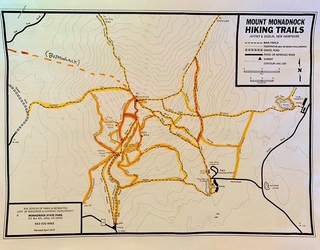
I live in Vermont only around 20 miles from Mount Monadnock, so I decided to climb every trail on the Official Monadnock Map. I just finished red-lining the entire map yesterday (Or orange-lining which is the color highlighter I used LOL).
It was an awesome experience climbing these 40 miles of trails over the past two months. I finished it off with a bushwhack to the summit.
I would say the best trail is the Pumpelly trail. Cliff Walk is another fantastic trail with amazing interesting rock terrain and killer views. The toughest would be the Red Spot and Spellman trails. Monadnock as some impressively challenging terrain and in my opinion encompasses everything an awesome mountain should be.

49916046273_09ddb25d87_z.jpg
 
Nice.
I am doing a similar project i started back in January.
Redlining Wachusett every month this year. It's about 17 miles of trails plus more, considering you are going to have to do some of it twice.
I have narrowed it down to three specific loops that I do to minimize back tracking.
I don't know what the actual milage is because, I don't carry a gps or use any apps.
One month this year I plan on doing it in a day, something i mentioned doing on another thread dating back to 2009.

There is also a patch available if you redline all the trails ( does not have to be completed in one day ) if, you're into that sort of thing.
 
Dave: I actually thought about if all the trails could be climbed in one continuous day hike. I don't think it would be possible because of a) the distance apart of the trail heads at the bottom of the mountain and b) The amount of back-tracking one would have to do would make it much, much longer than 40 miles of hiking.
However, people are always shattering unthinkable records, so nothing would surprise me at this point!

Steve: That's cool about Wachusett, that is a fun mountain!

There are tons of old trails on Monadnock, some from over a century ago. My understanding is that some of them are still sort of followable, while others are non-existent at this point. My goal was just to complete the official current map.
 
Nice.
I am doing a similar project i started back in January.
Redlining Wachusett every month this year. It's about 17 miles of trails plus more, considering you are going to have to do some of it twice.
I have narrowed it down to three specific loops that I do to minimize back tracking.
I don't know what the actual milage is because, I don't carry a gps or use any apps.
One month this year I plan on doing it in a day, something i mentioned doing on another thread dating back to 2009.

There is also a patch available if you redline all the trails ( does not have to be completed in one day ) if, you're into that sort of thing.
4 years later.....
Hi how do I go about getting info for the Redliner patch? Please and Thank you
 
Many of the major lists were officially put on hold during official Covid travel restrictions and any hike occuring during those periods would not count.
Covid-19 Moratorium. April 12 - May 3, 2020. All peaks and trails, in all states, visited during this time period will not be counted towards any list on this website.

http://www.48x12.com/
Not my rules
 
Top