Some beautiful views in Down East Maine

vftt.org

Help Support vftt.org:

This site may earn a commission from merchant affiliate links, including eBay, Amazon, and others.

Papa Bear

New member
Joined
Sep 3, 2003
Messages
1,922
Reaction score
176
Location
New York City
Some beautiful views in Down East Maine

October 23, 2008

Tunk Mountain, Burke Hill & Pigeon Hill plus
a special historic site in the blueberry barrens: the Epping Base Line.

About a week ago I was planning a trip to Northern New Hampshire to do some hike with Nate and bag a few peaks near the Canadian boundary. So I figured if I'm going to Pittsburg, NH (from NYC via my son's place in Natick, MA), why not stop off in Downeast Maine the day before, since it was almost on the way :rolleyes:.

The New Hampshire hiking will be in another report, but here I will describe my one day in Milbridge Maine and environs.

What's there? Why go about 700 miles (rt) out of the way? This:


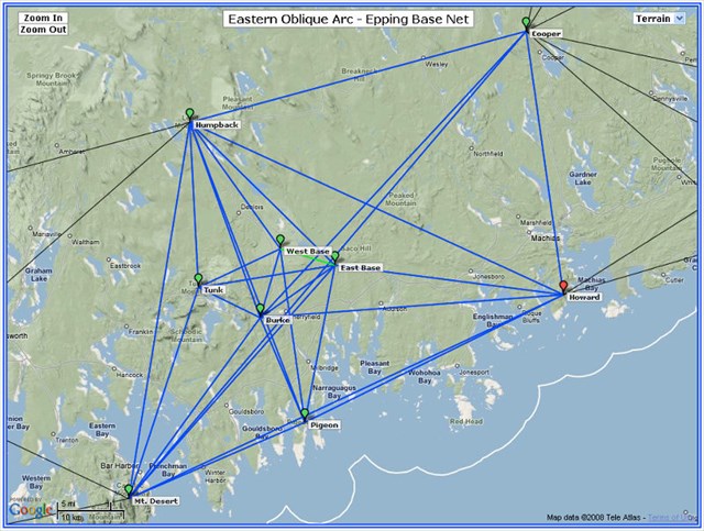
(click on this screen shot to get the interactive Google Map)

This is a map of survey points set in the 1850s by the US Coast Survey as part of the first accurate survey of the East Coast. Now each of those points had to be visible from other points connected by the lines on the map, so it's clear they chose peaks with great views. And they were right. Except for the two points on the Base Line (East and West Base) which are special, these are all very prominent peaks.

And I picked a great day - cold, clear with blue skies and views from the mountains to the Atlantic. Mt Desert (Cadillac Mtn), Humpback (Lead Mountain) and Tunk are known to most of us (they are in the Maine Mountain Guide in the chapter on peaks east of the Penobscot) but Burke abd Pigeon were delightful surprises.

Mt Desert (Cadillac) is not part of the report nor is Cooper or Howard (visited last year) but bring up the map and click on the icon and you can get a couple of links if you're interested. I did Humpback (Lead Mountain) about a month ago on my Katahdin trip and I'll add a note on that but the real reason for my visit were the 5 in the middle.

Tunk Mountain (1150')
I left Natick about 5:30 on Thursday morning, got to Bangor about 9:30, headed down to Ellsworth, then East on US Route 1, got onto Route 182 and by 11:00 AM I was at the Tunk trailhead.

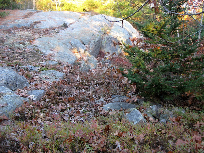
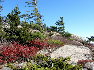
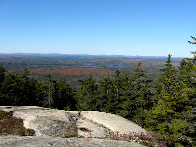
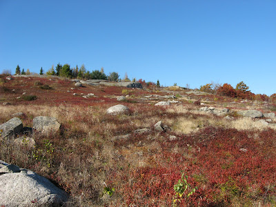
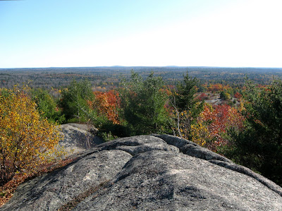
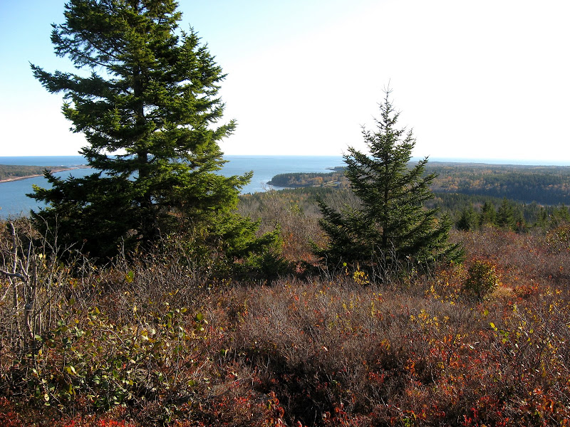
I did not follow the directions in the MMG, but went in from the west side, which is probably an easier route (not sure - never did the MMG's route). After about 1.5 miles on dirt roads and a couple of miles on foot I got to the ridge line and the views just opened up.


(click for larger images)

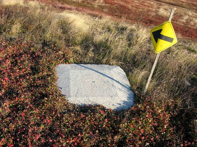
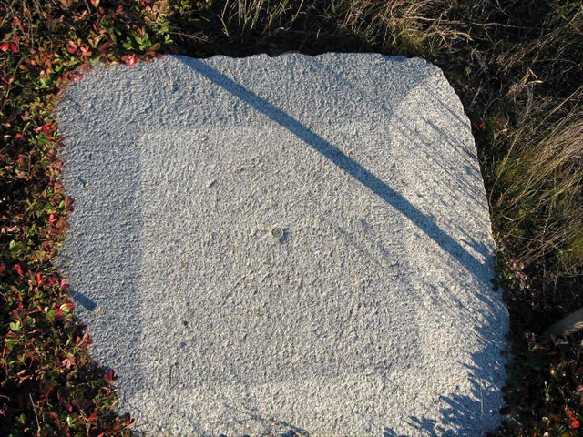
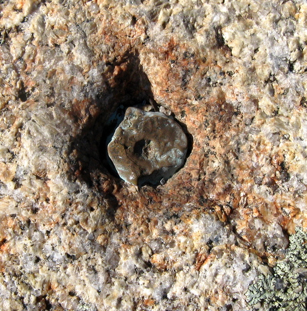
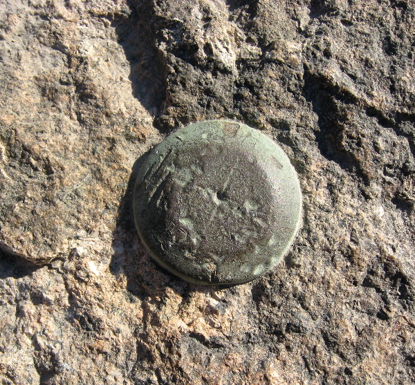
And here's the original survey marker, a copper bolt set into the ledge in 1859:

(click for larger image)

This is one of the hidden gems of downeast Maine with views at least as good as you might get on Cadillac, and what is more, no road, no gift shop and no crowds.

In 2 hours I was back at the car heading for Burke Hill.

Burke Hill (425')
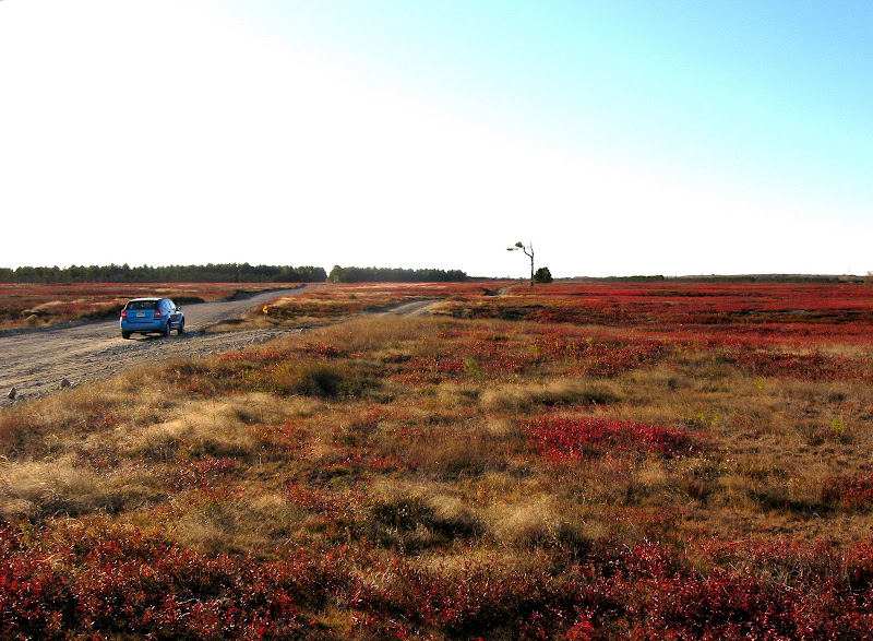
Towards the east end of route 182, there is a road off to the right signed the "Unionville Road", I took this right turn and drove about .7 miles to a place where there were open blueberry fields on the right of the road. I had a nice chat with and old fella who lived in the old farm house there. Seems he is the parson of a church in Harrington. "Course you kin climb the Hill, yep, been in the famly over 100 years". "How do you get to the top". "You jus gotta climb it!" :). Turns out an old road led up through the blueberry fields and then an easy whack over mostly open ledges to the top. The Hill was lower than Tunk, but closer to the coast so the views were equally breathtaking.


(click for larger images)

This was a quicky, less than an hour up and down, so now it was down to Pigeon, perched on a cape thrusting up into the coastal waters.
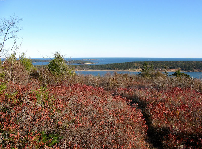
Pigeon Hill (317')
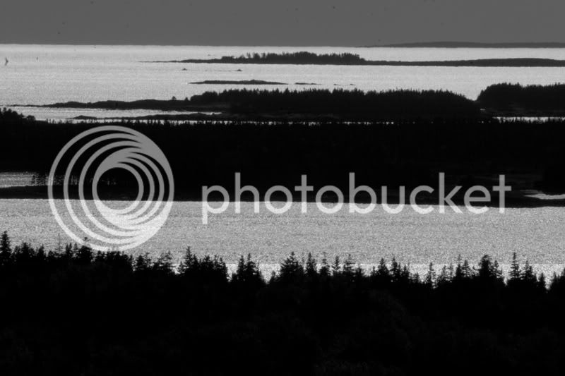
This was the lowest, the easiest to get to, but I'll be darned if it didn't have the best views.

There is some development going on on the west side of the hill (alas!) and a dirt road leads close to the top. The builder was working on the last house. He said times being what they were, he wasn't sure if he could sell it. I was a great setting, but alas it's pretty dead in this vicinity after Labor Day.

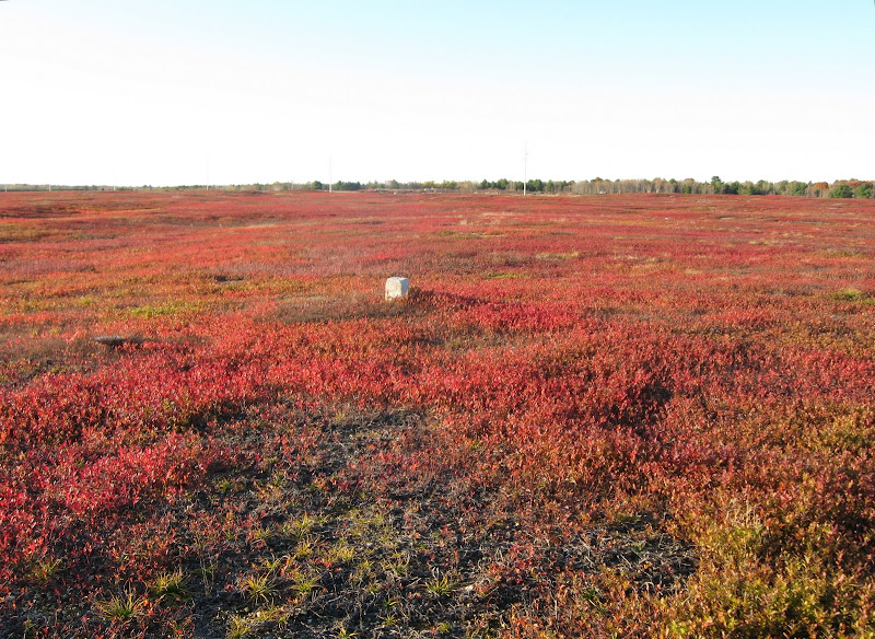
It was but a short trek to the top from this last house, and was it ever outstanding. Yes the 1855 mark was still in great shape (another copper bolt). A great finish for my 3 peaks in a day. (Little peaks with big views).


(click for larger images)

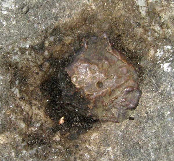
And here's the 1855 copper bolt:

(click for larger image)

Here's an album of all this stuff (minus the survey markers): Album

Notice the difference in foliage between Downeast Maine and northern New Hampshire. Yep!

And here are the logs on the benchmarking web site I belong to for these stations:
Log for Tunk
Log for Burke
Log for Pigeon


In the next note I'll explain a little about the "Baseline" and the important part it played in the survey.
 
Last edited:
The Epping Baseline

This will be a short (very short) explanation of old fashioned (pre-GPS) surveying.

The method used to determine the relative locations (basically latitude and longitude) of a number of points in a geographic area, is called triangulation. The basic idea was to construct a series of interlocking triangles, and using the rules of geometry, they could compute all the locations once a starting point was known. Since these triangles were actually measured by sighting from any give point to the nearby points, they had to pick points that were visible one from another. So naturally they used mountain tops. And sometimes in cities and towns they used church steeples or similar landmarks.

But two things are missing once all the angles of the triangles were measured: an overall orientation (which way is north) and a scale (how big are the triangles). To find the orientation they measured stars and consulted astronomic charts (much as we would look for the north star on a clear night). And to set the scale they had to measure (on the ground) at least one side of one of the triangles and from that they could set the scale for the rest.

This was easier said than done. The longest they could hope to measure a line was about 5 or 6 miles. Since many of the triangles had sides that were sometimes 50 or 60 miles long (look at the map at the top of the thread - the line from Mt Desert to Cooper is about 92.87 kilometers = 57.70 miles, and the longest line in Maine, Mount Pleasant to Ragged Mountain is 135.16 kilometers = 83.98 miles!), any small measurement error would get multiplied by a huge factor. So they measured the "Baseline" (as it was called) carefully. And I mean very, very carefully. They used metal bars, in this case 6 meters long and aligned them along a carefully laid out route. They compensated for temperature and inclination and height above sea level. When they could, they used a straight stretch of a railroad (as was done in Massachusetts) , or along a beach (as was done in Long Island, NY). But as we know, in Maine there are no beaches and the railroads don't go straight :), so they found an area that was long and relatively flat. The blueberry barrens of Cherryfield (the "Blueberry capitol of the world"; so says the sign) fit the bill and that was where they laid out the line. The area was known as the Epping Plains or the Epping Blueberry Barrens and hence the name of the baseline. The distance was measured over several months in 1857, and the accuracy of the 5.4 mile line was calculated to be on the order of 1 part in 500,000. The final corrected measurement from 1857 was 8715.9422 m with a probable error of 0.0158 m. Recent GPS measurements actually confirm this impressive accuracy.

Of all the baselines measured in the 19th century (of which there were a couple of dozen) by the Coast Survey this is the only one which still exists - that is to say which has both ends still in existence and in good condition. In all other cases over 150 years of "progress" has obliterated most traces of these early survey marks. I found one end of the Massachusetts baseline (See here), the other end is long lost. Both ends of the Long Island Baseline (on Fire Island) are long gone. Thankfully, Maine is one state in the East where progress has not run amok (not yet anyway).

Enough talk. The blueberry barrens are alive and well and beautiful in late October. For directions, bring up the map and click on the icons and follow the links (or ask me).

The right hand fork in the left photo is the actual path measured in 1857.
The right photo shows a reference mark set in 1934.

(click for larger images)

The left photo shows an 1857 reference point.
The right photo shows the granite ledge which marks the west end (a copper bolt is set in the slab)

(click for larger images)

The left photo shows the east end (A granite block amidst the blueberry plants)
The right photo shows the bolt in the center of the block.

(click for larger images)

The left photo shows the copper bolt for the east end.
The right photo shows the copper bolt for the west end.

(click for larger images)

This 5.4 mile long historical artifact is one of the foundations of all the maps and geodetic locations going back to the mid 19th century. And it's still there among the blueberries. The two ends are hardly peaks, but they are way cool, and they're certainly on my list.

Here are the logs on the benchmarking web site I belong to for these two stations:
Log for Epping East Base
Log for Epping West Base


And here's an album of all this stuff (minus the survey markers): Album
 
Last edited:
Nice

Very interesting. Thank you for sharing this.

Fitz
 
Papa Bear,

Thanks for sharing your newest adventures. I did not know that a survey line
was up in Washington, Co., ME. I've always wanted to check out the area, and now seeing your report and photos (which are absolutely beautiful) has further perked my interest.

Regards,

Ridgewalker
 
I really want to thank you for taking the time to pull this all together. Great explanations and I've had a lot of fun reading through many of the links. Next summer I'd like to go find Pigeon Hill myself.

So interesting!:)
 
From Pigeon Hill, last month:

IMG_2981.jpg


Pigeon Hill was recently conserved by the Great Auk Land Trust. Great Auk is now working on a Phase II which will add even more land. Last month I got to bushwhack around the hill with one of the trustees, scouting new trail routes. That area has a lot of interesting history as well as topography.
 
From Pigeon Hill, last month:

Pigeon Hill was recently conserved by the Great Auk Land Trust. Great Auk is now working on a Phase II which will add even more land. Last month I got to bushwhack around the hill with one of the trustees, scouting new trail routes. That area has a lot of interesting history as well as topography.
Thanks el-bagr

That is great news, since I was fearful that the development on the west side of the hill would only grow when the economy improves.

The Great Auk site mentions a "traditional trail". I scouted out the place and could find no trails. An old log on the government's survey marker site (this) indicates early treks were from the vicinity of the cemetery on the east side. And I couldn't find the woods roads mentions in the 1934 or 1970 reports. I finally settled on a short whack from the new road built by the developers (Bay View Drive) which worked fine but I guess would be less accessible once the road is fully populated with summer mansions (some of those places are BIG).

Is there a map of the Great Auk lands anywhere? Do you know where the "traditional trail is?

There is a National Wildlife Sanctuary further down the peninsula (I think it's called Petitte Manan) so luckily the lowland portion already has some protection.
 
The Great Auk site mentions a "traditional trail". I scouted out the place and could find no trails. An old log on the government's survey marker site (this) indicates early treks were from the vicinity of the cemetery on the east side. And I couldn't find the woods roads mentions in the 1934 or 1970 reports. I finally settled on a short whack from the new road built by the developers (Bay View Drive) which worked fine but I guess would be less accessible once the road is fully populated with summer mansions (some of those places are BIG).

Aw, that's a shame -- you'll have to go back! The traditional trail up from Pigeon Hill village is definitely the best route. We always park right at the cemetery:
IMG_2973.jpg


The 'trailhead' is across the road from the cemetery and perhaps 100' south. It can be tricky to find; I started going there with a friend who has spent every summer down at the Point for 60 years, and even he has to search for it. As I recall, there's a ditch to step across from the road, and just north of a utility pole is the trailway. Once you're off the road it becomes obvious.

Alternatively, if you drive (or walk) up the west side, from the top house (which was just built this summer and will soon be inhabited), it's a short walk on a decently-obvious but unmarked trail -- that must be what you took. From the summit, if you descend east, you get good views to the east over Bois Bubert Island, Jordan's Folly, Red Head, etc., and north toward the Grand Lake Stream country, all of which you can't see from the summit itself. Hope you got over there! From those eastern ledges, the trail drops steadily down to the cemetery site.

By the way, I just found the survey report site last Friday while scouting some local terrain. It's a very cool resource. I don't know about the old roads mentioned in the survey reports, but next time I'm there (likely January) I'll check it out. (The roads aren't shown on the 1904 Petit Manan quad.)

The refuge is also a very nice place. The trail to Chair Pond is particularly interesting. Skulk around enough out there and you'll meet a guy who has devoted the last 4 decades to documenting the dragonflies and damselflies of Petit Manan -- talk about local knowledge!

P.S. I'll try to talk my friend into releasing the Great Auk map. They do have excellent cartographic resources.
 
Great report and loved the pics!! I hiked up Tunk Mountain a few years ago, helping a friend with a write up for a previous Maine Mountain guide. I remember how nice the views were from up there. :) So, many neat places, so little time!!

For a great low level coastal hike, go to Great Wass Island, and do the five-mile loop that the Nature Conservancy has marked. It goes through a bog, complete with a great board walk. There are pitcher plants, and other great bog plants. Then, it comes out to the ocean,and the trail passes along granite headlands with wonderful views. To my way of thinking it is one of the best coastal walks in DownEast Maine. Great Wass is connected to the main land via a bridge.
 
I wanted to add two pieces of information to this thread for folks who may be interested in climbing the peaks:

Tunk Mountain - directions

I mentioned I did not take the MMG route (which is from the east) and instead went up from the west. I got the directions from Geocaching.com since there is a geocache on the peak (no - I didn't look for it). The general directions (with some helpful waypoints) are here: Tunk Geocache

The directions are good and the waypoints are good, but I would amplify the last line "follow the road down and across a seasonal brook then up to a trail on the left". Actually, you cross the brook and then follow the woods road quite a while (maybe .3 miles) to the right, and then there is a small cairn and a clear trail with occasional blue blazes going up to the left.

The trail is easy all the way up. No scrambles up steep ledges. From reading the MMG route, I'm guessing this approach is easier.

the road into the trail is signed "Myrick Pond Road", a dirt road. It leaves Route 182 about a mile west of the MMG road. Follow this dirt road, bear right at a fork, and then turn up a hill at another fork (the left fork is blocked here). I actually parked at this second fork and walked to the parking waypoint (I thought the initial part of this last road was a bit rough for my rental), but it was all easy.


Lead Mountain aka Humpback

On my map at the beginning of this thread this is called Humpback, an old name for the mountain. I hiked it with my daughter about 6 weeks ago on our Katahdin trip. The MMG directions are good but remember when you enter the dirt road off of Route 9, you must quickly take a left turn onto a second dirt road (opposite the fire department building). We missed this turn to the second dirt road and drove several miles on the wrong road.

The hiking directions are good and the going is easy. You basically hike straight up from the parking spot. Once you pass the side road to the U. of Maine station, keep going up till the power line ends, then swing up to the left to the top. There are actually two parallel "paths" here. the upper one is the trail, and the lower one is the line where they buried the power lines. It's nice they buried the lines, but it's a bit of a mess with these two paths. Maybe it will grow in.

It was a bit foggy so I don't have any good photos, but on a clear day this should be another worthy peak with great views. There are actually two survey markers: a USGS disk centered between the footings of the old fire tower, and a USCGS triangulation disk with 2 Reference mark disks about 200 feet to the south (go find it - it has better views). This second station is a 1934 reset of the original 1858 station. (a "reset" is when they place a disk in an old drill hole while preserving the location. So this disk marks the exact location of the original drill hole). The two nearby reference marks (the disks have arrows on them) point to the main station.

Here's my log: Log for Humpback
 
Last edited:
I just finished adding a thread on this trip on the benchmark hunting forum I belong to: Thread on Down East Maine trip.

The forum is hosted by Groundspeak.com but is affiliated with Geocaching.com.

It is longer, more technical and is oriented more to the surveying aspects rather than the hiking aspects of my trip, but it may interest some folks here.
 
Last edited:
Millbridge? Holy moly! I haven't heard of anyone going to that town since...well....we did about ten years ago. We spent a week in a cabin and kayaking every day. The lobsters were cheaper than chicken up there. We were there for 8 nights, and had lobsters 5 times. We'd wait for the lobsterdude to dock at the dock, he'd dump out his catch...and we'd route through them and pick ours out. We were paying about $1.50/lb if I recall. They went from swimming in the ocean to swimming in our pot within about 30 minutes. Good times.

Great pics and thanks for the memories!
 
Top