Advice sought on Isolation with bushwhacks

vftt.org

Help Support vftt.org:

This site may earn a commission from merchant affiliate links, including eBay, Amazon, and others.

Elizabeth

New member
Joined
Mar 9, 2010
Messages
275
Reaction score
31
Location
Lyme, New Hampshire
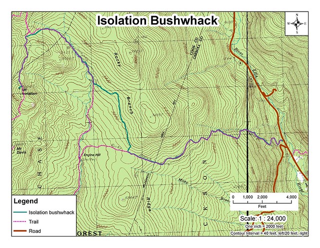
If the cold weather holds out a bit longer, I'd like to take the pups for a snowshoe trek into Isolation, following the bushwhack route(s). Could some kind person give me a somewhat detailed description of the route? GPS coordinates perhaps? Maybe even share a shapefile of the track?

Thanks,
Elizabeth

(I will also continue to follow this site and others for up-to-date information on the trail condition.)
 
I posted this description long ago on VFTT before GPS's were commonplace and Mohamed preserved it for posterity

http://home.earthlink.net/~ellozy/isolation-bushwhack.html

I obviously didnt spell check but the information was good. Do note that the second bushwhack seems to have fallen out of favor even though it can save significant time. I like it as on a nice day its in the sun. Do note that the last 1/4 of mile of the second bushwhack before the intersection with Davis path is extremely thick with fir and is a challenge but Davis path itself can be a challenge at times.
 
I posted this description long ago on VFTT before GPS's were commonplace and Mohamed preserved it for posterity

http://home.earthlink.net/~ellozy/isolation-bushwhack.html
Your original posting is still available at http://www.voy.com/76694/19.html

There is another page listing a number of routes at http://hikenh.netfirms.com/XIsolat.htm. (D+F is a popular winter route.)

There is also a good bit of route info in http://www.vftt.org/forums/showthread.php?t=5572 and http://www.vftt.org/forums/showthread.php?t=15691

Doug
 
Last edited:
Thanks for all of the responses so far. I will keep an eye on trail reports, and hope for some nice big group of snowshoers to go ahead of us!
 
I'd bet there's a pretty good track there - it gets broken/rebroken-out throughout the winter!!! Without any recent storm activity of significance, it's probably VERY obvious!!!
 
The second bushwack was broken out in February and is a great time saver. Not sure if the break out has been kept alive.
QUOTE]

The map on the website is a bit fuzzy and hard to read. Does the second bushwhack from February leave off more or less where the first one ends and head up to the summit? Or does it take a completely different route?
 
I dont recomend the E route on the "fuzzy" map as it follows the drainage up the valley to the col which tends to have lot of small brush, it ends up in the same place but I recommend starting farther north on rocky branch trail (about 3200 elevation) to avoid the brook where the growth is a lot thicker. The trees are somewhat more mature slabbing the slope on the north side of the valley and intersecting the brook at the last minute (where it them becomes real thick).
 
The second bushwack was broken out in February and is a great time saver. Not sure if the break out has been kept alive.
QUOTE]

The map on the website is a bit fuzzy and hard to read. Does the second bushwhack from February leave off more or less where the first one ends and head up to the summit? Or does it take a completely different route?

Yeah, pretty much. If you extend that E line across the 3200 contour you are basically drawing the first bushwack.

The E route in February ended on the Davis Path just steps from the Isolation Spur trail. Bryan Cuddihee broke it out And gets the kudos.
 
The map on the website is a bit fuzzy and hard to read. Does the second bushwhack from February leave off more or less where the first one ends and head up to the summit? Or does it take a completely different route?

Note that "D" on the map is not the same as the higher level cutoff KR mentioned, I have no clue which way UD went but presumably her tracks connect through :)

The E route in February ended on the Davis Path just steps from the Isolation Spur trail. Bryan Cuddihee broke it out And gets the kudos.

I have done that variation downhill, as I recall it was very steep at the top :) The gradient is gentler coming in at the col, yes there is a short band of spruce there
 
Thanks for all of the responses. Using the file sent to me by Tim, I threw together this little map to take with me. It loses a bit of clarity in being converted to jpeg, and I reduced the sized to fit it here (find a larger size by clicking on it and going to the Flickr link).


Isolation Hike by Elizabeth W.K., on Flickr
 
Last edited:
Elizabeth, personally I would go for what's already broken out. I know of one small group headed out there tomorrow that are familiar with the bushwacks so you may be all set. For the 1st bw pick up the glades at the HOL and stay in them across the 3200 contour, some folks stay lower but that's where the non stop glades are. :)

Agree with Roy , and your route will get you there. If the second bw is still broken out, it will pop you out on the DP very close to the Iso Spur.

Roy, KP stands for? I always refer to that line as Engine Hill BW.
Happy hiking !

Sabrina
 
Last edited:
Top