April 18-20, Nine Modest Hills

vftt.org

Help Support vftt.org:

This site may earn a commission from merchant affiliate links, including eBay, Amazon, and others.

Papa Bear

New member
Joined
Sep 3, 2003
Messages
1,922
Reaction score
176
Location
New York City
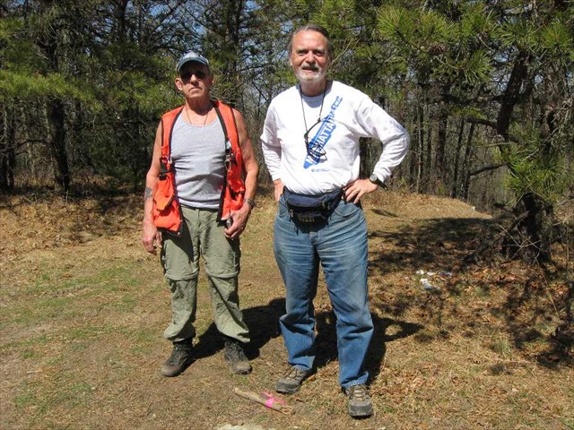
A couple of weekends ago, I spent half of Friday and almost all of Saturday and Sunday "bagging" what most would call modest (perhaps "meager") hills in Massachusetts (plus one was in Rhode Island). A friend Dave met me for most of Saturday and all of Sunday's fun. From my base in Natick Massachusetts, I drove 625.6 miles, and used 19.66 gallons of gas costing $65.70. This was all for 9 hills (plus one locked gate).

So for my target group (9) that's 69.5 miles per hill with an "assault" time of between 1 minute and 30 minutes per peak. (Did I say "1 minute"? - yes, read on.) Pretty sparse peak bagging, you might say. So I say, look at this map:

30e97fb2-6111-48d6-bb8a-c962f034d831.jpg


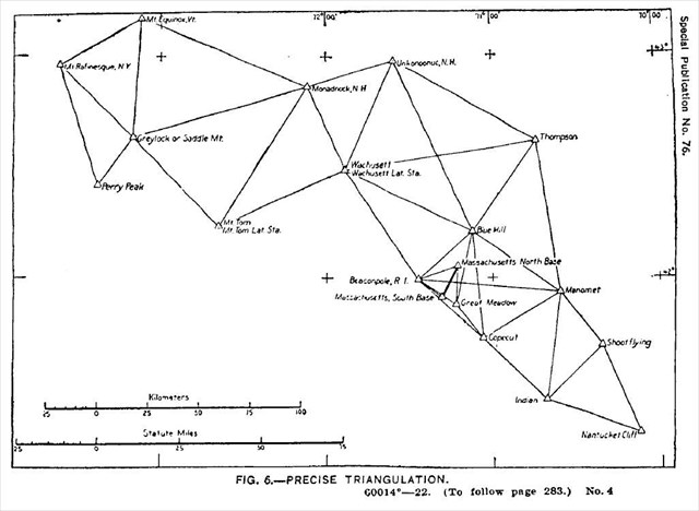
So what is that all about, you say? Those hills were used by surveyors in the 19th century Triangulation of Massachusetts (which formed part of the Eastern Oblique Arc) which took place between 1833 and 1874. And since you asked, the survey report (yes, with all the latitudes and longitudes) was published in 1922 as USCGS Special Publication No. 76. As for the "Eastern Oblique Arc", let's not go there in this forum, but if I've piqued your curiosity, start with this: Eastern Oblique Arc for Muggles or this: Eastern Oblique Arc for Geeks. But if you ever worried about datums and how we got them, take a look. (And yes it's datums, not data).

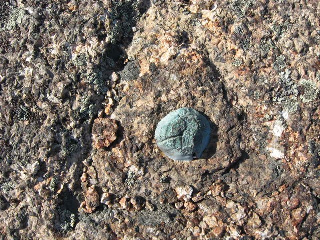
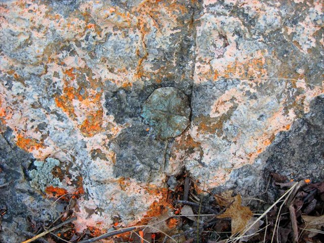
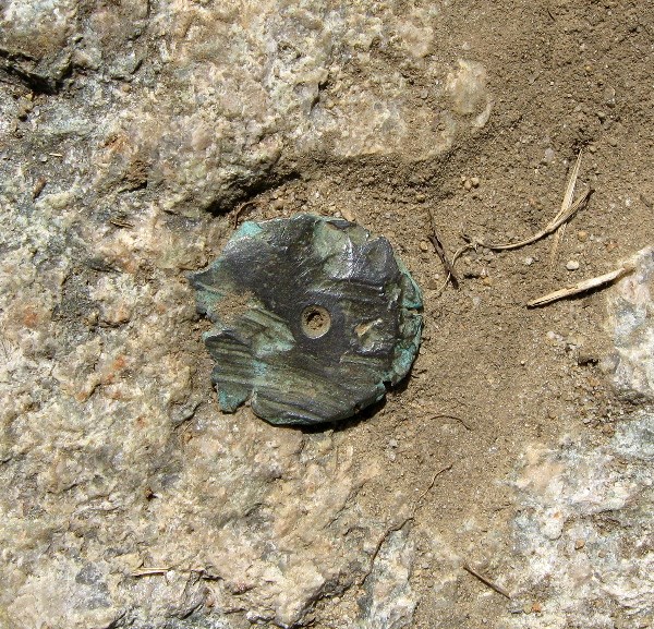
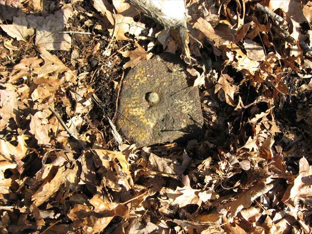
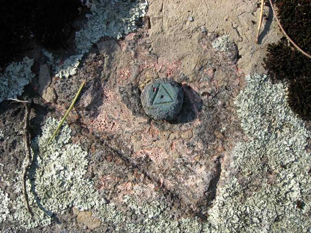
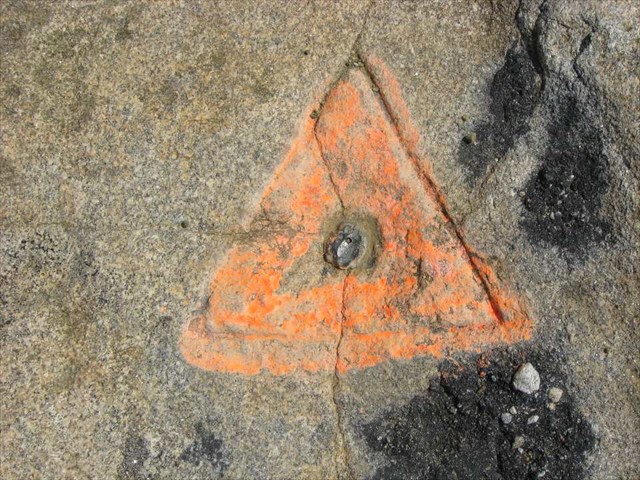
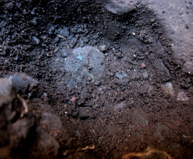
By now, those who know me realize this is about finding benchmarks, very old benchmarks - or survey markers as we prefer to call them. These particular "stations" are all "Triangulation Stations", a sub category of survey markers. Many of you have been to a good number of these "peaks" and never noticed right where you were standing was an old copper bolt, or maybe a drill hole in the rock. That copper bolt or drill hole just may have been there for 175 years!

Well, every hill on that map is beyond my capacity for one weekend, especially since the driving was much longer than the hiking, so here's what I "chewed off":

Friday:
Thompson Hill (1845) aka Mount Ann

Saturday:
Shootflying Hill (1845)
Pine Hill (1835, reset 1932) - a no cost extra
Manomet Hill (1835)
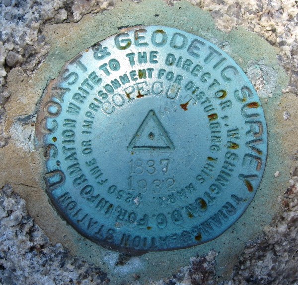
Copecut Hill (1837, reset 1932)
Massachusetts North Base (1844)
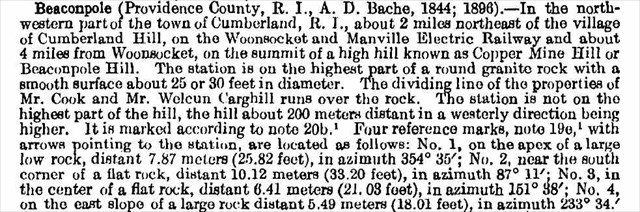
Beaconpole Hill (1844, reset 1932)

Sunday:
Blue Hill (1845)
Mount Wachusett (1833, moved 1895, reset 1936)
Mount Tom (1862)

The dates are when the surveyors did their stuff. "reset" means a disk replaced the original mark, generally in the 1930s, when surveyors had nothing better to do.

Of the others on the map, Nantucket Cliff was lost 100 years ago and the Equinox and Graylock survey markers were destroyed when the summits were "defaced" with structures. Massachusetts South Base was evidently destroyed when new tracks were laid some time prior to 1934, and Great Meadow is in a National Guard facility which was closed and locked tight when we went there on Saturday.

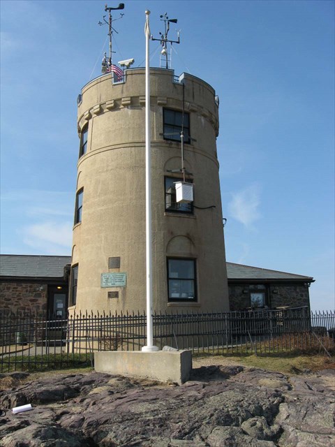
Here's my report on the benchmark hunting forum I belong to: Benchmark report. I'll summarize the trek from a hiking/peak bagging perspective here. Note to Fire Tower baggers: Many of these "peaks" were fire tower peaks in the past. A couple (Copecut and Wachusett) are still Active. This is not an accident, since the peaks that had the best views, also made the best spots for triangulation stations. Look at that map again: each line connecting one or more stations indicates there was a direct line of sight between the two stations and the surveyors actually observed one station from another (today, we're lucky to see the Pudential Center from Big Blue Hill. Think of seeing Unkonoonuc from Big Blue, or Monadnock from Mount Tom!)
 
Last edited:
Note: for each report, there is a benchmark ID and name of the station. This is a link to the benchmark report on the benchmark hunting site which will have more pictures. Next is a link to a Google Map showing details of the locale. You can use the selector in the upper right to see a Topo Map, Street map, etc. Zoom control is in upper left. Then there is one or more pictures. Click on a picture for a larger image.


Friday

MY4858 - THOMPSON <- click for Benchmark report (with lots more pictures)
Copper bolt set in 1846

Google Map


(Click for larger image)

This station is on Mount Ann in Mount Ann Park near Gloucester. The land is owned by the Trustees of Reservations and I talked the manager into hiking up there with me to see what the station was all about. Public access is currently restricted due to issues with neighboring land owners.

There was a great deal of anguish on this board over the possibility that I would commit the high crime (or misdemeanor?) of "Trespass" in getting to this peak. No such thing happened. I simply called the park administrator, explained what I wanted to do, and he and his assistant drove me to the "trailhead" and accompanied up me to the peak. Actually both the owner of the park land, and the owner of the land you must traverse to get there have no problems with hikers, and the land is not posted. It's the guy who lives next to where you park, that calls the police all the time (the police also don't have a problem with the hikers). If you don't park there (or if you drive a Trustees of Reservations Truck) you are fine.

It was about a 20 minute walk on a lovely Friday afternoon. The views from the open rocky peak were impressive. The station and all 5 reference marks were recovered.


Saturday


LW3984 - SHOOTFLYING
Copper bolt set in 1845

Google Map


(Click for larger image)

This peak was undoubtedly the high point of peak bagging achievement for the weekend. I would hazard a guess that none (or maybe Roy?) of my fellow VFTTers have ever even attempted this monster. And it's a (former) Fire Tower peak. This surely rivals even Rhode Island's Jeremioth Hill as an accomplishment, and surely get's far few attempts than that one.

This station is actually in the center median of the mid-cape highway in Barnstable. Luckily there was little traffic at 7:00 AM Saturday and I could park on the left of the west bound lanes. There use to be a rest area there but there is no trace of it now. There was a faint grassy road leading to the station. I also found 2 of the 3 reference marks, but shanks only.

Total mileage to summit: .015 miles. Elevation gain: 6 feet. Hiking time: 48 seconds.


LW4436 - MANOMET
Copper bolt set in 1835
Google Map

Dave and Papa Bear on Manomet

(Click for larger image)


(Click for larger image)


I met up with Dave (ddnutzy) for this station and we worked together the rest of the weekend. The summit of Manomet Hill is about a 10 minute walk from Route 3A. We found the station and and 3 reference marks (RM4 Reset, RM6 Reset and Manomet Magnetic). We didn't find RM1, and RM5 was destroyed when the boulder it was on was moved down to the town fire house (with a memorial plaque attached).

This station is the oldest of the primary Massachusetts triangulation stations still in existence, and a county high point to boot. There a couple of reference marks in the area (disks) which most folks mistake for the "benchmark" for Manomet. Meanwhile there's the 1835 copper bolt sitting right in the middle of the clearing, all but ignored. Ah, ye muggles!


LW2119 - COPECUT
Copper bolt set in 1837, Reset with standard disk in 1932
Google Map


(Click for larger image)

The road up to Copecut Hill was a beast with large holes everywhere. Travel was slow. There is a fire tower on the top and there was a fire warden there who said hello. Rather than opening the gate, he (and we) just walked through the large hole in the fence. There was nothing on the datasheet about a reset, so we didn't know what to expect. What we found was the station disk and 1 RM disk in good condition. We did not find the other 2 RMs after a brief search. Given the out of the way location, this area gets very little traffic.


MY3577 - MASSACHUSETTS NORTH BASE
Copper bolt set in 1844
Google Map


(Click for larger image)


This was the north end of the base line for the Massachusetts Triangulation. What's a base line? A very carefully measured line (accurate to about 1 inch in 10 miles - this done in 1844!) which sets the size of all the triangles in the survey and hence the scale for the whole state survey.

This station is behind a relatively new house on Summer Street in Foxboro. We were lucky that a woman drove up just as we arrived. She said to go ahead and search and that we were not the first to search for the "old tower" (which we knew had been demolished about 100 years ago).

We first found Reference "11MB" (near the RR tracks) - with the help of my GPS and metal detector - and measured off the distance to the station, but could not find it after much digging (we found many pieces of brick from the old tower). Then we "guessed" RM2 (which was not described in the datasheet but appears in the box score) was a 1/4 inch hole we found in a boulder to the north of the station. Taking a measurement from this drill hole led us to the station, which was in plain site!

This site compares with Shootflying for toughness. The elevation gain may actually have been negative! Some may question whether this place even qualifies as a legitimate peak. All I can say is what George Mallory said "Because it's there!".


LW2764 - BEACONPOLE RESET
Copper plug set in 1844, reset with a standard disk in 1932, only the shank remains
Google Map


(Click for larger image)


This is located on a Hill which is on state land (in Rhode Island) but which is abit tricky to find. Luckily Dave had been to this one before. The top is gated (but not posted) and there are radio towers as you would find on many of these hills.

The station mark is the shank plus a small portion of the center of the 1932 disk with the triangle and center dot preserved. Thus the geodetic point is preserved and this station is actually in "good" condition in spite of the damage. It almost looks like a copper bolt, but alas it is a disk shank.

The station and 4 reference marks (RM1, RM3 Reset, RM4 Reset and RM5) were recovered. We could not find RM2 (a drill hole). All disks have been removed with only shanks remaining.


And that was the end of our 13 hour Saturday adventure
 
Last edited:
Sunday was a tough day: we actually had to climb (on foot!) to the summits of these three suckers. :D

Sunday


MY3472 - BLUE HILL
Copper bolt set in 1845, currently buried
Google Map


(Click for larger image)


This proved to be the one big disappointment of the weekend. We had read all the logs on this site and knew that several benchmarkers had said that the flag pole had been built over the copper plug, but we had to see for ourselves. We found 4 reference marks (3 drill holes: old RM2, old RM3 and old RM4 and the 1932 disk: RM1). RM2, another 1932 disk was not found and presumed to be underground inside the observatory fence. Careful measurements from each of these recovered reference marks indicated the station was directly under the flag pole.

Our only hope (a slim one) is that when they built the flagpole base, they placed a pipe from the top down to the ledge where the mark is (was?) so that by removing the flag pole, a surveyor could sight on the 1845 marker. But as for now, the 1845 copper plug is lost (but not forgotten).


MY3792 - WACHUSETT 2 RESET
Copper bolt set in 1833 , moved in 1895 due to construction, reset in 1936 after being damaged by a car
Google Map


(Click for larger image)

The original copper bolt set in in 1833 is still intact. However it was moved twice in its history, the first time (in 1895) by men building the summit hotel (long since burned down); it was put back and was renamed Wachusett 2, then the stone it was set in was hit and moved by an automobile in 1936 so it was reset and renamed Wachusett 2 Reset. But the copper bolt is the original Simeon Borden bolt of 1833. So although the bolt (1833) is the oldest of the lot, the station (which is the well defined and measured location of the marker) dates from only 1936.

The station and 5 reference marks (RM3, RM6, RM8, RM11 and Wachusett Magnetic) were recovered. One (RM10) was found moved about 40m from its correct position. Several others are lost or under the parking lot. A compass rose was also found, a rather attractive monument.


MZ1808 - MOUNT TOM
Copper bolt set in 1862
Google Map


(Click for larger image)

We managed to drive entirely around Mount Tom before finding the best way up. The directions given on the datasheet by (RPM) in 2004 are the best directions but we neglected to read them (till I got home). We finally got some good directions from one of the rangers and ended up hiking up the old summit railway right-of-way, now a paved maintenance road. This also passes the B17 Crash Site and Memorial, which gets a fair amiount of tourist traffic.

The station and 4 reference marks (RM1, RM2, RM4 and RM5 - 1937 Eccentric) were recovered. We could not find RM3 or the 1936 Eccentric. We also found MZ1807 "Mount Tom Borden" an 1835 copper bolt. That was a major find - see the next note.

And thus ended our weekend with 8 out of 9 stations recovered. Not bad at all.


Extra Credit

LW4668 - PINE HILL RESET
stone post set in 1835, reset with standard disk in 1932
Google Maps


(Click for larger image)

On Saturday, between Shootflying and Manomet, I met up with a group of County High Pointers (wow! hitting high points in every county - how obsessive! :)) for a visit to Camp Edwards, a National Guard base. Visits must be pre-arranged with the base.

This was not one of the primary stations but was a secondary station - a 4x4 inch brown stone monument set in1835 by Simeon Borden. This original marker was lost and was reset using an underground mark (a bottle buried 3 feet underground) in 1932 with the current disk.

A surveyor had set up a tripod with a GPS antenna over the mark. So soon we will move from an 1837 stone post to a 1930s disk to a 21st century high-tech station. What would Simeon Borden who set the mark in 1833, or A.D. Bache who managed the survey from the 1840s to the 1860s think about that!


MZ1807 - MOUNT TOM BORDEN
Copper bolt set in 1835 by Simeon Borden
Google Map


(Click for larger image)

After recovering that station Mount Tom and most of the RMs, we set about finding this one. This mark is 18" underground and until recently a building was on top of it. But a few years ago, the nearby air beacon tower and the equipment building which was over the mark were removed, and so we had a chance.

We took the distances from reference points given in the 1896 and the 1934 recovery logs. After repeated measurements and digging for about an hour, we hit bedrock and found a depression in the bedrock. Dave cleared it out and said "I see a copper bolt with a cross on top"

We found it! We checked the measurements and it was right on from the two early descriptions. The photos were difficult to get since the bolt was way down in the hole and we continually knocked dirt and gravel down on top of it.

We believe we are the first to recover this since 1934, and therefore we are very likely to be the only two folks alive to have seen it.

A great way to end a great weekend. :)
 
Last edited:
Papa Bear said:
SHOOTFLYING
I would hazard a guess that none (or maybe Roy?) of my fellow VFTTers have ever even attempted this monster. And it's a (former) Fire Tower peak.
Not me. I was actually by there on a fire tower tour, but being Sunday afternoon in summer it would not have been easy to have explored it.

BEACONPOLE RESET
I hope you bagged the summit and not just the BM, it's the most prominent peak in RI according to AM

I've been to most of those places but lacking your information and dedication never searched out the survey marks
 
RoySwkr said:
...
I hope you bagged the summit and not just the BM, it's the most prominent peak in RI according to AM...
Alas no. As you lacked the survey marker information, I lacked the prominence information ...

I just now looked at the early survey report:

a4564e60-2656-4464-9519-8968c9c6d390.jpg


And although we seemed to be at the highest point, the report indicates that it is higher about 200m to the west. The Topo map also shows a closed contour at the same elevation, but rather larger over there.

How many times do we finally study the directions, the hints, the clues, the essential things AFTER we get home!

Edit: Just studied the Topo a bit more. It would seem someone has built a fairly large house a little NE of that other spot. Bring up this map: Google Map. It should come up in Topo mode. (Although Google and the Terraserver both seem rather sluggish today) Now use the selector in the upper right and switch between Topo and Satellite. What do you think? Was that house there when you went? The actual high point (estimated from the closed contour) looks to be rocky and a bit SE of the house. Probably could be whacked from his driveway.
 
Last edited:
It must be nice to work with such accurate descriptions, in the last month I've reported 2 to NOAA with given coordinates maybe .2 miles from point described

If you ever get to Gatineau Park near Ottawa, there's a place called King Mtn which is supposed to be the base for the planimetric survey of Ontario but of course I don't have the details you crave. It does have a nice view of the Ottawa River valley

Papa Bear said:
The Topo map also shows a closed contour at the same elevation, but rather larger over there.

Was that house there when you went?
We went in the 80s before the metric maps came out, the foot map shows 547 spot elev at BM with 550 contour "over there"
http://docs.unh.edu/RI/pwtc49nw.jpg
We also went to the BM area but not knowing its significance I just said we saw some disks

There was no house on or near the summit then, but a lot of hilltop homes have been built recently - snuck past another one today. I need to become a chimney sweep or satellite TV installer if I intend to keep bagging ever-lower hills.
 
Top