
arghman
New member
- Joined
- Sep 1, 2004
- Messages
- 1,352
- Reaction score
- 153
I hesitated on whether to post; I've been feeling kind of anti-trip-report over the last few weeks. But there's one detail (the fire rings) that tipped the balance slightly...
I saved Carrigain for the last NH4K, in part because that seems to be the consensus (from my friends as well as the which-to-finish-on thread here), and in part because my foot's still been bothering me off and on & I didn't want to get to 47 and be stuck with a really long hike. In retrospect, though, I would have chosen Isolation or Bondcliff.
The weather forecast looked kind of iffy (20% chc of showers/Tstorms in the morning increasing to 50% later in the day) but I figured if I got an early start it should be OK, and if I didn't go then, it would be raining the whole next week & I didn't want to have to deal with swollen brook crossings.
The lower part of the trail is nice -- the Livermore area seems to be kind of a rich woods, somewhat uncommon in NH with its typical acidic soil / granite / glacial till. I saw lots of sugar maples & beech & some other common rich-soil indicators (purple-flowering raspberry, spikenard, etc.). Brook crossings fairly easy (but we've had little rain in the last few wks), I guess only the first one would be a problem & only if there were a lot of recent rain / snowmelt. This is another one of those trails (like the Hancocks) that gets you warmed up on a flat section, & then heads upwards towards the summit. The middle section is kind of boring birch/spruce-fir/etc through sections which switchback every now and then.
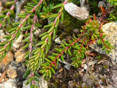
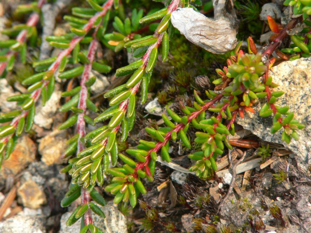
Carrigain's east ridge is a nice example of subalpine heath: Labrador tea, mountain cranberry, blueberry, fir, and another good place to see both species of crowberry side-by-side (purple = Empetrum eamesii has the whitish hairs, black = E. nigrum does not):
also good views of Vose Spur and Mt Lowell.

Too hazy/humid for long-range views (Washington should have been visible but was not), but I'm not a views fanatic.
A nice ridge of at least 500' in length, open to the northeast (but not the SW where fir trees block the view), at about 4400' elevation. Then it drops back into the woods to head up towards the summit.
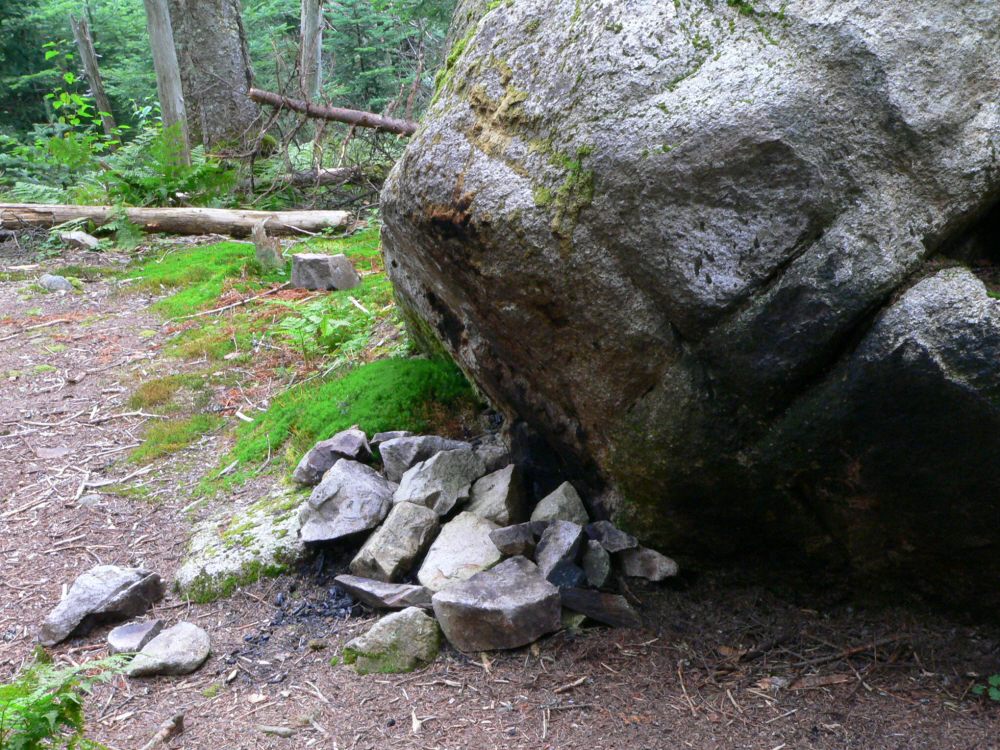
I had the summit & firetower platform all to myself, spent a few contemplative minutes up there. I wandered around the summit area and here was my mistake. There were 3 fire rings with recent charred wood within about 200' of the summit (one practically at the summit to the north / northeast), also a bunch of wads of toilet paper scattered around near one of them. Out of all of the summits in the WMNF that I've ever been to, this one has had the most sign of human abuse. (also the firetower platform doesn't particularly help) (Except for maybe Mt Washington, but the summit proper is in the state park, not in WMNF) I hope this is not typical for Carrigain & that I just caught it at a bad time. (dear idiots who did this: why do you need to have 3 fire rings anyway, can't you re-use someone else's?)
Found another fire spot heading down a few hundred feet:

sigh. I went back to the crowberry heath area & had lunch there. I'd definitely come back to this spot again, but not sure I'd want to visit the summit a 2nd time unless someone scouted ahead & said the fire rings were gone. There were a handful of other people around, I saw maybe a dozen between 11:30 and 12:30, and another dozen or so on my way back downhill.
About halfway down, in an area of hobblebush & birches, all of a sudden I felt a sharp pain in my right hand, between my pinky & wrist -- some kind of insect had stung me, I never even saw the stupid thing. (My hand is still swollen up in that area.) This sort of thing reminds me why I should rethink hiking alone so often, good thing I'm not highly allergic to bees...
FYI -- Sawyer River Rd seems to be equally distant from the I-93 / Rt 112 exit in Lincoln, whether you take I-93 through Franconia Notch and then Rt 3, or whether you take the Kanc and Bear Notch Rd. I timed it at 48 minutes one way, 49 minutes the other.
I saved Carrigain for the last NH4K, in part because that seems to be the consensus (from my friends as well as the which-to-finish-on thread here), and in part because my foot's still been bothering me off and on & I didn't want to get to 47 and be stuck with a really long hike. In retrospect, though, I would have chosen Isolation or Bondcliff.
The weather forecast looked kind of iffy (20% chc of showers/Tstorms in the morning increasing to 50% later in the day) but I figured if I got an early start it should be OK, and if I didn't go then, it would be raining the whole next week & I didn't want to have to deal with swollen brook crossings.
The lower part of the trail is nice -- the Livermore area seems to be kind of a rich woods, somewhat uncommon in NH with its typical acidic soil / granite / glacial till. I saw lots of sugar maples & beech & some other common rich-soil indicators (purple-flowering raspberry, spikenard, etc.). Brook crossings fairly easy (but we've had little rain in the last few wks), I guess only the first one would be a problem & only if there were a lot of recent rain / snowmelt. This is another one of those trails (like the Hancocks) that gets you warmed up on a flat section, & then heads upwards towards the summit. The middle section is kind of boring birch/spruce-fir/etc through sections which switchback every now and then.
Carrigain's east ridge is a nice example of subalpine heath: Labrador tea, mountain cranberry, blueberry, fir, and another good place to see both species of crowberry side-by-side (purple = Empetrum eamesii has the whitish hairs, black = E. nigrum does not):
also good views of Vose Spur and Mt Lowell.
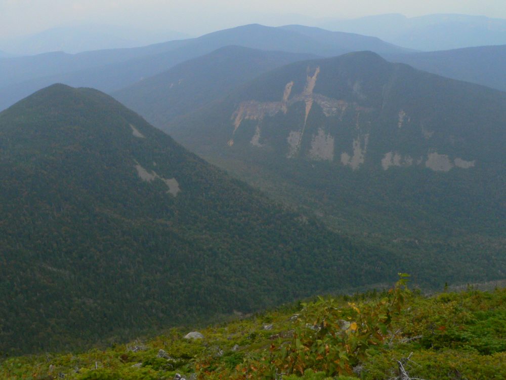
Too hazy/humid for long-range views (Washington should have been visible but was not), but I'm not a views fanatic.
A nice ridge of at least 500' in length, open to the northeast (but not the SW where fir trees block the view), at about 4400' elevation. Then it drops back into the woods to head up towards the summit.
I had the summit & firetower platform all to myself, spent a few contemplative minutes up there. I wandered around the summit area and here was my mistake. There were 3 fire rings with recent charred wood within about 200' of the summit (one practically at the summit to the north / northeast), also a bunch of wads of toilet paper scattered around near one of them.
Out of all of the summits in the WMNF that I've ever been to, this one has had the most sign of human abuse. (also the firetower platform doesn't particularly help) (Except for maybe Mt Washington, but the summit proper is in the state park, not in WMNF) I hope this is not typical for Carrigain & that I just caught it at a bad time. (dear idiots who did this: why do you need to have 3 fire rings anyway, can't you re-use someone else's?)Found another fire spot heading down a few hundred feet:
sigh. I went back to the crowberry heath area & had lunch there. I'd definitely come back to this spot again, but not sure I'd want to visit the summit a 2nd time unless someone scouted ahead & said the fire rings were gone. There were a handful of other people around, I saw maybe a dozen between 11:30 and 12:30, and another dozen or so on my way back downhill.
About halfway down, in an area of hobblebush & birches, all of a sudden I felt a sharp pain in my right hand, between my pinky & wrist -- some kind of insect had stung me, I never even saw the stupid thing. (My hand is still swollen up in that area.) This sort of thing reminds me why I should rethink hiking alone so often, good thing I'm not highly allergic to bees...
FYI -- Sawyer River Rd seems to be equally distant from the I-93 / Rt 112 exit in Lincoln, whether you take I-93 through Franconia Notch and then Rt 3, or whether you take the Kanc and Bear Notch Rd. I timed it at 48 minutes one way, 49 minutes the other.