Evergreen Mtn-Catskills

vftt.org

Help Support vftt.org:

This site may earn a commission from merchant affiliate links, including eBay, Amazon, and others.

Jay H

New member
Joined
Sep 8, 2003
Messages
5,283
Reaction score
236
Location
Pittsfield, MA
Evergreen doesn't seem to be in the catskills 100 list (it's west of Rusk and before Pine Island). Is this because it doesn't satisfy the 250' rule between the peaks, there is certainly about a 400' drop to the col/shoulder from Rusk but the climb up to Evergreen is only about ~200' or so max. It's certainly far enough from Rusk to count as my GPS was saying 1.75 miles straight line.

Got no reply from the catskills 3500 group so thought I'd ask here.

Very nice bushwack from Rusk, good views without the tree cover into Spruceton Valley and points north towards Windham.

Jay
 
Evergreen has the addition of a hunters stand. It's an elaborate metal stand and offers a view in the fall and winter. It may add about 12 feet to the summit.

Regardless of whether it's considered a seperate peak, it's still a nice climb. The Catskill 3500 Club is leading the hike on April 16. Ellie is leading the peak with Rusk and she is doing it as a traverse.

Moose
 
Evergreen Elevation

Earlier this month I climbed Evergreen and measured its summit by GPS at 3400 ft. The highest point is a well defined knoll. With a good clear signal, my GPS usually matches measured summit elevations very well. The col with Rusk is very poorly defined; it sort of meanders and rolls along (would make a good golf course). I agree that the lowest point (how ever that is defined) is about 200 ft below the summit. It is a rather long, but nice, side trip from Rusk.

Joe
 
moose_mckenzie said:
Evergreen has the addition of a hunters stand. It's an elaborate metal stand and offers a view in the fall and winter. It may add about 12 feet to the summit.

Regardless of whether it's considered a seperate peak, it's still a nice climb. The Catskill 3500 Club is leading the hike on April 16. Ellie is leading the peak with Rusk and she is doing it as a traverse.

Moose

I'm curious, is that stand on state land?

Evergreen has some nice cliffy areas.

I seriously doubt that a handheld GPS would give a 100% accurate reading on anything. But then again, the Catskill maps are still based on 1950's era surveys.

Despite the fact that it is not a mountain according to the Catskill 3000' rule, you are still able to hike it, as long as you're on the state land!!
 
Yeah, I think the ridge itself is state land. It isn't close until you get to Pine Island, I think. Don't have the maps in front of me.

How hard is it to navigate the little needle of state land that runs down to across the Devil's Path terminus on Spruceton Road? When I drove past the DP trailhead, I made an effort to look across and although I could believe to see Evergreen, it looks like somebody's property, somebody who has a really nice spread, complete with a helicopter inside a nice wooden building with a windsock on top.

My original plan was to spot a car there and go down from Evergreen instead of back over rusk, but since we only had one car and my friend lost a basket and a glove on the way to Rusk, we decided to just backtrack. (we found them both too!)

Jay
 
I figured we'd have to cross the West Kill, the idea being that worst case scenario, since it's at the end of our hike we would simply change out of the wet boots at the car spotted there.

I'd imagine the west kill is going to be flowing pretty good after this weekend if they're getting the same rain I'm getting right now.

Jay
 
A rousing loop hike can be had by combining a traverse of Evergreen and Rusk with one of West Kill Mountain and St. Ann's Peak (West West Kill Mountain). I did this a couple of years ago with a friend, starting with a bushwhack up Evergreen from Spruceton Road to simplify navigation on the finger of state land. Frankly, though, this section is rather remote and I doubt anyone would ever take notice if you accidentally wandered onto a private holding.

Your car can be parked at the western terminus of the Devil's Path Trail (confusingly called "Mink Hollow"). The West Kill leg of the hike is all trail, along the Diamond Notch and Devil's Path trails. Evergreen and Rusk are, of course, an easy bushwhack though open deciduous woods. I'm at work right now and away from my maps, but the routes are obvious and the distances easily calculated,

porky pine
 
Hey David, I think I might of seen a trip report of you exactly on this. I did a search of Evegreen on VFTT archives before posting this question. That would make a pretty good loop.

Actually, the next time I'm up in the region, a traverse of the whole range would be nice, go over packsaddle and Pine island and figure out some legal way to get to Spruceton or all the way to 42. A GPS might be handy just to ensure you don't wander onto private property.

Jay
 
Packsaddle and Pine Island?

Jay H said:
...a traverse of the whole range would be nice, go over packsaddle and Pine island...

I only have the NYNJ trail maps in front of me (specifically #41) and I don't see this Packsaddle or Pine Island labeled. Can you offer more specifics? Are you referring to the 3100' bump west of Evergreen?

Kurt
 
Like this?

HunterMountainRangeAnnotated.jpg


Tony

PS. Have I mentioned how much I like Worldwind? ;)
 
Last edited:
Lexington Range (some more info on the mountain names)

E. Schlimmer and Tony very nicely answered the Packsaddle and Pine Island question. The ADK Guide to Catskill Trails gives some more info on the names of the mountains (in a Rusk Mt. Bushwhack section). Arnold Guyot (the Princeton University Professor of Geology and Physical Geography) surveyed the Catskills in 1880. His map showed names of five peaks in the Lexington Range. His names do not agree entirely with the current names/maps. From west to east his names were (elevations are the current highest contour line):
3100' Lexington (currently unnamed, but generally called Packsaddle)
3140' Pine Island (currently unnamed, but still generally called Pine Island)
3360' Bee Line (currently Evergreen)
3680' Evergreen (currently Rusk)
3640' Rusk (currently unnamed, but generally called East Rusk)​
Packsaddle, Pine Island, and Rusk are on the Catskill 3K list. The current Evergreen and East Rusk lack the necessary 200' prominence to be on the list. All of the names may have existed prior to Guyot's survey with the likely exception of Rusk. Rusk is named for Samuel E. Rusk who served as an assistant to Guyot, and also published an 1879 Illustrated Guide to the Catskill Mountains.

Note, the elevations that E. Schlimmer gave reflect the AMC's methodology of using the highest contour line plus half the contour interval (which perhaps more accurately reflects that the actual elevation is somewhere between the highest and next higher contour).
 
Looking at the picture I generated, there appears to be a great possible backpacking loop.

Starting out in West Kill (just off the right side of the picture) you could traverse the entire Lexington Range plus the Devil's Path Range (is there an official name for this range?) with Hunter Mountain at the far end of the loop.

This appears to be at first glance about 40 miles half of which is bushwhacking, hits five Catskills 3,500 peaks (six if you want to try for SW Hunter), plus several 3,000 footers. How much of this is on private land? Maybe 3 days for a normal human.

So many hikes, so little time.
Tony
 
Well, if you hike west all the way out to 42, you could also hit NE Halcott (Is this on the 3000ft list?), Halcott (the one with the canister) and then go back towards the Devil's Path by hitting Balsam Mountain (not the 3500' balsam. there are a lot of balsam mtns up there, eh?) then Sherrill, then North Dome.. Back to the devil's path, PissMeOff..Ummm St Anne's Peak, Hunter, SW Hunter... Might as well go all the way to Prediger.. Overlook, Oh... I'm getting ahead of myself...

:)

Nice picture Tony, BTW... I was trying to find the tower on Hunter...;)

Jay
 
Jay H said:
Nice picture Tony, BTW... I was trying to find the tower on Hunter...;)

If you want that all you need is the 1meter Ortho overlay versus the Landsat 7 overlay. You also need to look from the east. Now can you find it? :cool:
huntermountain1mortho.jpg


Tony
 
Yup...:)

I've played with terraserver and finding the tower on balsam Lake before, you could spot that and also the building on Graham too.

Jay
 
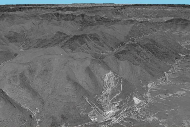
Tony, the loop you are asking about could be done entirely on state land. The northwest corner is unfortunately not on the NYNJTC maps, however, it is shown on a large fold-out map included in Michael Kudish's book 
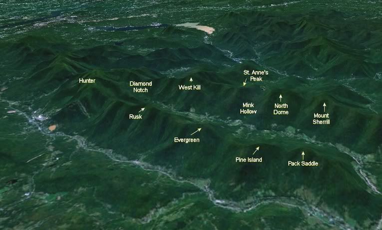
The Catskill Forest: A History. There is a swath of state land that comes down to the Spruceton Road, County Route (CR) 6. On the west the swath is about 0.4 miles east of State Route (SR) 42, and extends to about 0.6 miles east of SR 42. The eastern boundary appears to be at a bridge over a side stream flowing down from the south, and a short distance before a bridge over the main West Kill stream on CR 6. I have never used that swath of land, nor do I recall if there are any convenient parking spots. After fording the West Kill a straight line up the ridge would take you to a point about 0.5 mile west of the 3100' summit of Packsaddle (aka Lexington). There is a jagged line of state land, at times narrow, and sometimes a little off the ridge top that leads to Pine Island and Evergreen. The summit of Pine Island may be a very short distance north of the jagged strip of state land.

The southwest end of the loop is all in the large West Kill Wilderness Area. As Jay mentions you can bushwhack between the Devil's Path and SR 42, over North Dome, Sherrill, and the 3340' Balsam (which is not on the 3K list, only 120' prominence). To answer Jay's question, yes, the 3408' NE Halcott (historically known as Sleeping Lion Mt) is on the 3K list.

The Catskill Range names are probably not official as they (with the exception of the "Blackhead Mountains") do not appear on the USGS quads. Kudish's book names all of the Catskill ranges. Often a range is named for the highest mountain, but there are many exceptions, e.g. Lexington rather than Rusk Range. Kudish uses the term Hunter Mountain Range to cover the ridge beginning with Overlook, Plattekill, all the mountains of the Devil's Path, continuing to Sherrill. By extension that would include the 3340' Balsam, a false summit of Sherrill. He also includes both Southwest Hunter and Hunter in the range.
 
Top