Herd Path between Jay and Big Jay

vftt.org

Help Support vftt.org:

This site may earn a commission from merchant affiliate links, including eBay, Amazon, and others.

akafuzzjones

Member
Joined
May 21, 2009
Messages
118
Reaction score
9
Location
Tewksbury, MA
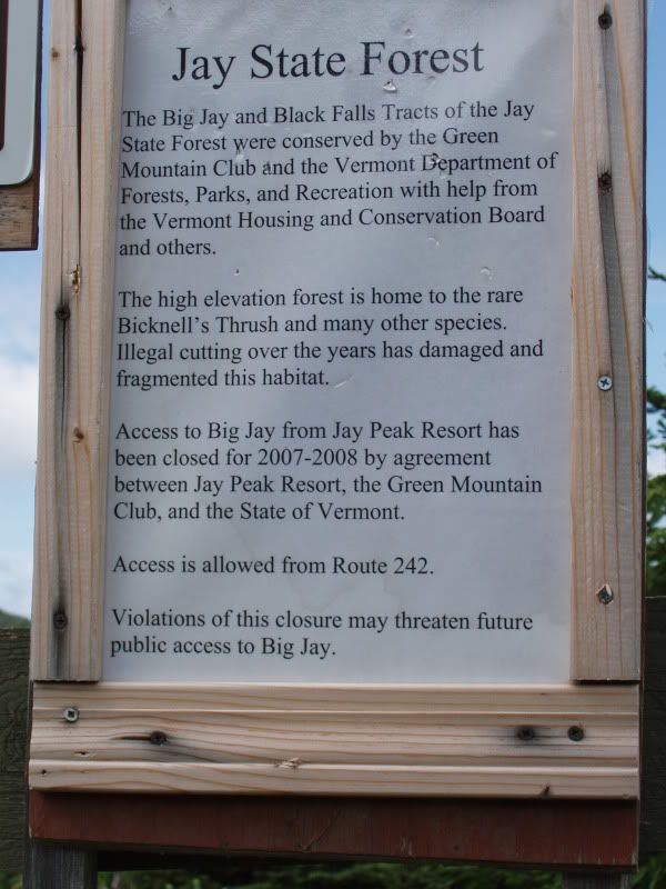
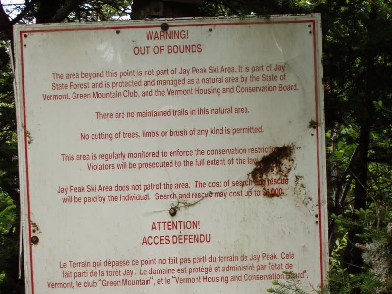
I am planning to knock these two peaks off the Hundred Highest List in June and someone told me that the herd path between the two peaks has been blocked by fences. I have not seen anything about this anywhere else and was wondering if anyone knew if this was true. I was thinking that maybe he was talking about the recently cut (illegal) ski trail that had the fence but he said that it was in fact the hiking trail. Thanks in advance.
 
You should be fine. Here is a thread I started nearly two years ago:


http://www.vftt.org/forums/showthread.php?t=24212

The fences were intended to stop backcountry skiers, not hikers. They may be fully removed, but if not, you should be able to get over/under/around them.

Enjoy the hike!

Marty
 
Herd path to Big Jay

Agree with Marty, not to worry. If there are any fences left you'll easily be able to go around them. I did so not too long ago in winter and in summer of course, even easier. Good luck finding he exact summit of Big Jay, in deep snow I did a lot of walking around, don't know if there's a cannister, I never found one but made sure I had covered all the high points.
Enjoy!
John
 
Good luck finding he exact summit of Big Jay, in deep snow I did a lot of walking around, don't know if there's a cannister, I never found one but made sure I had covered all the high points.
There used to be a canister. The fence is not to stop you from hiking, just to stop skiers from using the illegal cut.
 
The fence is to stop skiers from using the illegal cut (not the former herd path to Big Jay which was also an illegal cut) and keep skiers out until there is sufficient snow on the ground. It's not really a herd path anymore, it is a cut trail.
 
There was a glass jar on a tree in 2008. The fences were broken in places, cut in places, and in most places started 4' off the ground since they were put up during the winter to keep skiers out so crawling under was possible.

I do recall a fork in the path at one point, at the low spot shortly after leaving the Jay ski area. Be prepared to figure it out. :)

IMG_2474.jpg
 
As of 2007: If you're facing a big (BIG) sign that says "This is not part of the ski area and it will cost your firstborn for rescue," move right (north) about 50' to find a better start to the path. There may be a smaller sign there, but at any rate I don't recall having to do anything dramatic with fence-hopping or crawling. The only real point of confusion for me was thinking that huge sign had to be at the start of the path.
 
Here's a photo of the summit jar in late July 2008. The person in the photo is the late, great Ray Loring. The photo is titled "Big Ray on Big Jay".

ry%3D400


Marty
Interesting, the jar is literally that now, a jar. It used to be PVC. It was frozen shut the first time I went, and I remember whacking it to un-stick it, but to no avail. I'm sure I would have not pounded away on a glass jar!
 
Thanks for all of the feedback - I didn't think it was something I needed to worry about but wanted to make sure there wasn't some big land dispute because of that illegal ski trail. It would be a very long drive to only get one of the two peaks.
 
Was there this past March as well as last Nov... I found it a bit hard as well locating the glass jar. As the trail swings left you enter a semi cleared nice area amoungst trees just before it wants to descend as it swings south & west. (may not be exact bearings) If you have a GPS you will know you are where the summit should be. I back tracked alittle to near that last bend and hung a left, there's tracked areas here, you literally go 50 - 100 feet in this area and wahlah you see the small clearing with the jar...a bright orange ski rescue sled is probably leaning on a tree as well if it hasn't fallen over since the ice melt. the notepads are in disarray in the jar but still fun to read.
I spooked a moose as i departed back in Nov. It's a nice area to tromp around in, not much of a view around the cannister, but you'll go past some nice outlooks on the way over from Jay that you can back to after on the way back. ctsparrow
 
Hiked Jay & Big Jay 5/29/2010. The upper sign as shown in The Hikers photo has been removed. The stand is still there however no sign is present. Please note the sign reads 'closed for 2007 - 2008. The lower sign is still present but doesn't permit hiking only cutting of brush, etc.

The herd path branches left ~50 Ft past the sign. It is easy to follow although contains a few blowdowns and some very muddy sections. The herd path peters out at the summit.

The jar is present along with the sled leaning against a nearby tree. I organized the crumpled papers back into the appearance of a notebook.

Thanks for the recent data. If I remember I will bring a new notebook up there to add to the jar.
 
Top