1HappyHiker
Well-known member
Background:
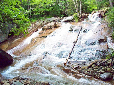
Having only about 4 hours to “play outside” yesterday, I took a short stroll (bushwhack, if you will) along Walker Brook and into the Walker Ravine. You know, it’s that “little” ravine on the west side of the Lafayette/Lincoln stretch of the Franconia Ridge.
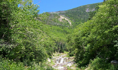
Anyway, I was surprised to find very distinct remnants of a trail, particularly on the north side of the brook before the point where it splits into a north and south branch. I meandered up the south branch to about 3200 ft of elevation before hitting my turnaround time. It’s pretty open in there and very easy going. I could easily have gone further if only I had the time.
I was surprised to have found remnants of a trail. So, as soon as I got home, I checked Guy Waterman’s booklet entitled: An Outline of Trail Development in the White Mountains. Here I read that there used to be a trail in that area called the Walker Ravine Trail (appropriately enough!!). However, Guy’s booklet indicates that this trail no longer appeared on AMC maps after the 1928 edition of the WMG.
Questions:
So, with that rather long introduction, here are my questions.
1) If someone has a 1928 edition of the WMG (or earlier), would you be kind enough to post information about this trail, such as where it began and ended, etc, etc?
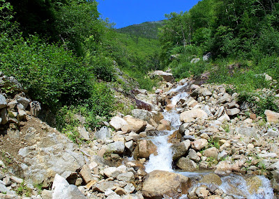
2) Has anyone whacked up the south branch of Walker Brook beyond 3200 feet, like maybe to the headwall of the ravine (or beyond)? I’m trying to determine if it’s worth a return visit to go beyond where I stopped. I know this is purely a subjective determination, but I’d be interested in any input.
Below is a photo taken from the point where I ended my whack. So, I’m curious what can be seen further up the ravine.
Having only about 4 hours to “play outside” yesterday, I took a short stroll (bushwhack, if you will) along Walker Brook and into the Walker Ravine. You know, it’s that “little” ravine on the west side of the Lafayette/Lincoln stretch of the Franconia Ridge.
Anyway, I was surprised to find very distinct remnants of a trail, particularly on the north side of the brook before the point where it splits into a north and south branch. I meandered up the south branch to about 3200 ft of elevation before hitting my turnaround time. It’s pretty open in there and very easy going. I could easily have gone further if only I had the time.
I was surprised to have found remnants of a trail. So, as soon as I got home, I checked Guy Waterman’s booklet entitled: An Outline of Trail Development in the White Mountains. Here I read that there used to be a trail in that area called the Walker Ravine Trail (appropriately enough!!). However, Guy’s booklet indicates that this trail no longer appeared on AMC maps after the 1928 edition of the WMG.
Questions:
So, with that rather long introduction, here are my questions.
1) If someone has a 1928 edition of the WMG (or earlier), would you be kind enough to post information about this trail, such as where it began and ended, etc, etc?
2) Has anyone whacked up the south branch of Walker Brook beyond 3200 feet, like maybe to the headwall of the ravine (or beyond)? I’m trying to determine if it’s worth a return visit to go beyond where I stopped. I know this is purely a subjective determination, but I’d be interested in any input.
Below is a photo taken from the point where I ended my whack. So, I’m curious what can be seen further up the ravine.
")