baldpates (Grafton Notch), quick advice needed

vftt.org

Help Support vftt.org:

This site may earn a commission from merchant affiliate links, including eBay, Amazon, and others.

arghman

New member
Joined
Sep 1, 2004
Messages
1,352
Reaction score
153
Location
Goffstown, NH Avatar: No Once-lers or thneeds
I'm probably hiking the Baldpates this wkend, I need to know how much of a bad idea this is if it's rainy.

Also what's the condition of the road between Andover and the AT?

Or any other advice. (e.g. mileage for a there-and-back to both peaks via Grafton Notch, vs. mileage for a traverse)
 
West is a treed summit, so no problems there or on the way up. After West you descend into a very pretty col, then up open ledges to the open, ledgy summit of East.

So if they're predicting thunderstorms, you might want to bring a lightning rod or two! :eek:

bobandgeri are right about the beauty and about Table Rock.
 
Arghman - I believe you are referring to East B Hill Road, which goes between Andover Center and Route 26, intersecting with both the Frye Brook Trail and the AT along the way. That road is paved and quite passable. Last time I passed it, it was a bit chewed up close to Route 26 due to frost heaves, but still nothing to worry about.

Marty
 
Jason-Most do the hike from Grafton Notch. However if you do decide to start from the "other" side, you'll find the East B Road (gravel) is usually in very good condition (it's not a "rutted old logging road to the trailhead", but rather a road people in the area actually travel). When i last did these peaks, it was raining and i found myself scooting on my butt a number of places when descending the open ledges from the East Peak back toward the West. I'm not usually troubled by wet rock/slabs, but the trail down from the East Peak just seems a bit "off/angled" in too many places when wet. It 's easy to get on sections that are just a little too steep when soaked. Odd, but not sure else how to describe it. When dry, no problem.--have fun---jim
 
Ditto BobandGeri and Mad Townie on the standard up-and-back from Grafton Notch, including the worthiness of the Table Rock detour (which gives you a partial loop). I investigated a point-to-point ending up in Andover, to take in Little Baldpate and just for variety. It would have added about 4 miles, by unaided memory. As it turned out, I lacked the time and the necessary second car - it's much too long a car-spot to walk or take a chance on hitching.

The E. Baldpate ledges would be important to be off in a thunderstorm, but they're not terribly steep so I doubt that a little wetness by itself would make them hairy. You'd miss good views in poor visibility, however.
 
I did this hike last year from the parking lot shared w/ the Old Speck climb. It was a rainy day and the last climb up the second and higher peak was a little sketchy. It is pretty steep and it is all smooth rock. I took a little tumble coming down off of it. It isn't too bad, can be doable on a rainy day, just be careful.
 
buckyball1 said:
. . . . When i last did these peaks, it was raining and i found myself scooting on my butt a number of places when descending the open ledges from the East Peak back toward the West. I'm not usually troubled by wet rock/slabs, but the trail down from the East Peak just seems a bit "off/angled" in too many places when wet. It 's easy to get on sections that are just a little too steep when soaked. Odd, but not sure else how to describe it. When dry, no problem.--have fun---jim

I overlooked this part of Jim's post until after mine. Since he and King Tut, unlike me, have been on those ledges in wet conditions, you should obviously heed them. It is a view hike in any case so should be saved for a nice day.
 
East B Hill road is kept in good condition year round but does have its issues in the spring, dont worry about it this time of year. You are a adding a lot of extra miles if you intend to do the Balpates via the AT from the east (southbound). The normal quick route is via the maintainers trail that runs up the south side of the stream that feeds Frye Brook Notch, this is the old AT and is not really hard to find although it is not blazed. Basically park at the Frye Brook parking area, follow the old logging road keeping the brook on your right and go until the road stops. Folow the well defined path until you intersect the AT on the ridge line ( theres is a sign) and take a left to go to the Baldpates.

If its a hot day there are several swimming places along Frye Brook and its worth taking a detour and chekcing out the flumes and cascades.

Make sure you stop at Sunday River Brewing after the hike.
 
Baldpate in the rain

I did the Baldpates in the rain some time ago. On the whole th eledges are not especially steep and footing isn't a terrible issue but careful attention to the route is necessary if foggy because it is possible to lose the trail.

If you find some car keys, let me know.
 
I was on East B Hill Road last month. In fine shape all the way from 26 to Andover.

The ledges can be slick with a fair amount of rain. Ask Arm about his HH hike. Another thing to consider if it is EXTREMELY rainy is that the trail will become a brook on the final push to the West summit. Makes for a less than fun hike.

My .02: the Baldpates are way too beautiful, and accessible to do on a rainy day. If you are working on the HH, and are in the area itching for a hike, then do either Elephant or East Kennebago :) You won't miss any views that you would get on a clear day.
 
woohoo! well I went out yesterday, did a there-&-back from Grafton notch. A+ #1 perfect weather: mild temps, cool breeze, mostly cloudy, not humid. The group I was with ran into a few batches of thru-hikers but only 1 other day-tripping group; amazing for such a nice place on a Saturday with good weather.

We were there for a plant survey so lack of views not an issue -- but I have to admit, E Baldpate & the col betw W/E is one of those places where the views are a good chunk of the reward... the other being those ledges in between which IMHO are less difficult but more fun than Welch/Dickey or Baldface; less steep & there's enough stair-steppy-ness of them that it's not too hard to climb.


Hope to come back in a future year & do a loop from the other side, via the two trails on East B Hill Rd, & catch Little Baldpate. Ditto for Table Rock. (no time yesterday :/ )

Bill -- no car keys found, sorry; we did find an empty beercan stuck in a treestump though. :mad:

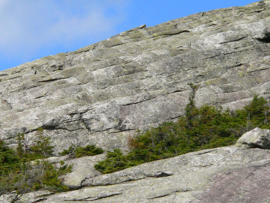
I greatly prefer the handmade white-lettering-on-brown-sign of MATC to the perfect dark-lettering-on-white sign of WMNF in the Whites.

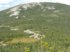
A question: there was a low bald mountain visible to the east, south of a pond with an island & some radio satellite things. Looking at the topo map, that looks like Whitecap Mountain in Rumford. Any comments on this -- is there a trail there & is it a worthwhile visit the next time I'm in the area?
 
Sunday River Whitecap ?

Can be reached by a fairly easy bushwack along a surveyed line and offers an expansive rocky summit with unusualy wide views and a somewhat more difficult bushwhack over to neighboring Slide Mountain.
 
arghman,

Glad you enjoyed the Baldpates! As for the ledges, try them with a nice coating of ice--makes them a lot more interesting! :D
 
The low bald mountain you saw to the east of the Baldpates was it this http://community.webshots.com/photo/553598214/2261909510072086107ZCGznS
there is a huge satellite listening station North east of the Baldpates with a low rocky crested ridge behind it. The picture I took was from Old Blue Mnt over by Richardson lake and Andover. I also would like to know the name of that bald ridge if that is the same one you were seeing.
Chris
 
FYI, in case anyone is interested, the satellite station is in Andover. It was built to communicate with the Telstar satellites, and I KNOW there are people around here who are old enough to remember those! Some of us even remember the Ventures song by the same title. :cool:

Not sure, but I think the ridge in the photo is Whitecap, just outside of Rumford.
 
Top