Waterfall in Northern Presidentials: Rollo Fall

vftt.org

Help Support vftt.org:

This site may earn a commission from merchant affiliate links, including eBay, Amazon, and others.

1HappyHiker

Well-known member
Joined
Jan 18, 2007
Messages
1,973
Reaction score
405
Location
Bethlehem, NH
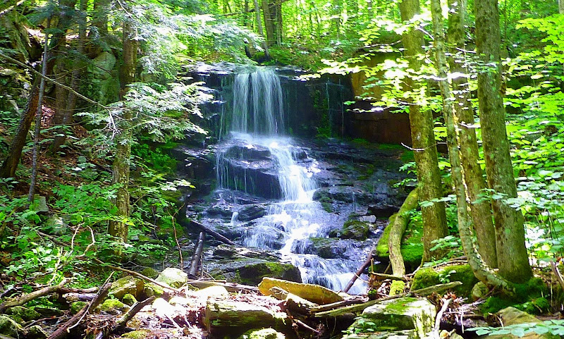
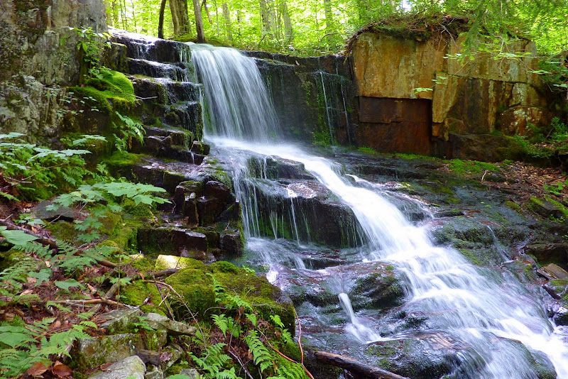
Below are two snapshots of a waterfall that I recently took from two different viewing angles. My question is as follows. Does anyone know if this is the spot that is named Rollo Fall in very old editions of the WMG? This waterfall is said to be on the Moose River which is located between the current day Lowe's Path and Castle Trail.

Most sources place Rollo Fall at an elevation of about 1550 ft elevation. However a few sources put this waterfall at an elevation that is several hundred feet higher. I took a GPS reading while standing at the bottom of the waterfall shown below. When I plotted the coordinates on a topographic map (and on GoogleEarth), I estimated an elevation of about 1810 ft.

So, here are the numbers to keep in mind:

1550 ft: Approximate elevation shown on old AMC topo maps, and the most widely accepted location for Rollo Fall.

1900 ft: Approximate elevation given on the Northeast Waterfalls website for Rollo Fall, and approximate elevation shown on map that is included with current edition of Randolph Paths guidebook.

1810 ft: Approximate elevation obtained when plotting GPS coordinates taken from the bottom of waterfall during my bushwhack.

Since there are elevation discrepancies among various information sources, I wonder if this perhaps could be a case where there is a lower and an upper Rollo Fall?:confused: I'd guess that this type of situation sometimes happens, and could lead to confusion with the passage of time. Some things are simply lost to history!

I have sent inquiries to a variety of sources and am still awaiting feedback from some of them. Of those from whom I've received feedback (including Steve Smith), all seem to think that the 1550 ft elevation is the more accurate number. In which case, Rollo Fall is NOT what is shown in the snapshots below.

I'm told that the lower portion of the Moose River is now on private property. This might complicate the proper way to solve this puzzle by looking for a waterfall around at 1550 ft. Regardless, the situation on this particular day was that I was doing some incidental bushwhacking on the east side of the Castle Trail when I intersected the Moose River at about 1750 ft. I bushwhacked along the bank up to an elevation of about 2100 ft. The waterfall at 1810 ft (shown in the photos below) is the only waterfall that I spotted along this segment of the Moose River.

P1060053.JPG


P1060055.JPG
 
Last edited:
I don't know the area at all, but from the photos, that falls would appear to only be about 6 feet high. My guess would be that that is not a falls anyone would give a name to.

The Moose looks like it has about a million tribs; any one of those might be considered "on the Moose River" for the purposes of describing a waterfall location. Looking at the Moose River drainage from Bowman down towards Appalachia, it doesn't seem likely from the topography that there will be a significant waterfall in that range of elevation on the South side (Lowe's Path) side of the valley. Looks a lot more likely on the North side, where numerous tribs appear to pass through steep terrain in about the right range of elevations...

Good luck in the search.

TCD
 
Let me begin by saying I have no clue where Rollo Fall is, but I often research old names and while old maps are good they aren't perfect

It appears that 1550' is just uphill of the powerline and while this seems to be private property I suspect it is like the lower Randolph Path etc and you are welcome to explore - so I'd go there and look. The new map doesn't offer much hope of a lot of gradient:
http://mapper.acme.com/?ll=44.35555,-71.33981&z=16&t=T&marker0=44.30451,-71.31758
 
Looking at the Moose River drainage from Bowman down towards Appalachia, it doesn't seem likely from the topography that there will be a significant waterfall in that range of elevation . . .

Let me begin by saying I have no clue where Rollo Fall is, but I often research old names and while old maps are good they aren't perfect.

It appears that 1550' is just uphill of the powerline and while this seems to be private property I suspect it is like the lower Randolph Path etc and you are welcome to explore - so I'd go there and look. The new map doesn't offer much hope of a lot of gradient:
http://mapper.acme.com/?ll=44.35555,-71.33981&z=16&t=T&marker0=44.30451,-71.31758
Tom, I agree 100% with you that the topography certainly makes it appear unlikely that there would be a significant waterfall in the area where Rollo Fall is reported to be located, especially around the 1500' to 1600' contour lines.

And Roy, I agree with you that old maps are not always perfect. And, I'll even go a step further by saying the even the latest topographic maps sometimes miss what I'll call a "micro-feature" in the topography.

So, with that little introduction, let me say that I feel that I've now located the true and genuine Rolo Fall. Although totally unexpected from the gradient shown on the topo map, this waterfall is situated on the Moose River just below the 1600' contour. Both my altimeter and GPS showed readings in the range of 1560' -1570'. This elevation is in keeping with what is shown on the old maps.

As to whether Rollo Fall is currently on private land or on WMNF land, I'm unsure. Some reliable folks have told me that it's on private land, whereas other equally reliable folks have told me it's on WMNF land. Regardless, I didn't walk across anyone's lawn to get to the waterfall, nor did I come across any signage to indicate who has ownership of the land on which this waterfall resides.

I bushwhacked along the bank of the Moose River from the north side of the Presidential Range Rail Trail all the way up to an elevation of 1810' (where I encountered the waterfall shown at the top of this thread in my original posting). The waterfall shown below is the only other significant waterfall that I encountered along the way. Therefore, I'm strongly inclined to believe this is the Rollo Fall that is mentioned in old editions of the AMC and RMC guidebooks.

A special thank you goes out to David Govatski, Steve Smith, Ed Rolfe, Dean Goss, Greg Parsons, and Judy Hudson for their advice and help with my quest to re-discover Rollo Fall.

Front View
Roll_FrontVu.JPG

Side View
Rollo_SideVu.JPG
 
Last edited:
Good stuff! That waterfall must look even better in high water. What would you say the height of the falls is? Looks 12-15ft-ish based on the pictures.

Which obscure waterfall is next on your radar?
 
As to whether Rollo Fall is currently on private land or on WMNF land, I'm unsure. Some reliable folks have told me that it's on private land, whereas other equally reliable folks have told me it's on WMNF land. Regardless, I didn't walk across anyone's lawn to get to the waterfall, nor did I come across any signage to indicate who has ownership of the land on which this waterfall resides.
That's about what I expected for the property situation; unless the USFS has suddenly acquired another tract your approach was certainly on private property which apparently the owner hasn't posted.

The new AMC map shows Rollo Fall about 1610' and the USFS boundary about 1620' so odds are good that the fall is privately owned - certainly if the RMC wanted a sign and trail they would check with the town to find out who the owner might be. On the other hand, with all the similar falls in the area there is probably no great demand and this one will be left to explorers like yourself who hopefully will do nothing to offend the landowner.
 
NeoAkela; Roadtripper; DiamondRidge: Thanks guys for your nice comments.

Roadtripper: Your estimate for the approximate height of the waterfall is right on the money! Between the bottom and the top of the waterfall, my GPS showed a 15' difference in elevation.

Roy: Regarding the land ownership situation for Rollo Fall, someone is checking on this situation and is supposed to get back to me.
If I receive any definitive information, I'll post it on this thread. I'm told that the Forest Service did make a recent land purchase in this general vicinity. But, at this point in time, I don't know if that land purchase included Rollo Fall.
 
My apologies for once again "bumping-up" this thread! However, I felt it is important to pass along the fact that it has definitely been confirmed that Rollo Fall is located just outside the boundary of the WMNF and currently resides on private land.

Perhaps it's a case of being an unrealistic optimist, but maybe by reawakening an interest in Rollo Fall, it will eventually result in the WMNF purchasing the tract of land where this waterfall resides. It's not just another waterfall in the Northern Presidential Range. It has documented historic significance as well. Nearly a century ago, this was the location for events held by the RMC, as described by Louis F. Cutter, in the 1924 volume, "Randolph Old and New",

If the WMNF could acquire the land, then a short spur path (less than 0.2 mile) could be constructed off the Presidential Range Rail Trail to lead hikers to Rollo Fall. With some judicious clearing of trees, the area around the base of the fall is very amenable to becoming once again a place where folks could comfortably sit and admire the waterfall and its surroundings. For families with small children, this would be an ideal introductory hike. Parking is already available at Bowman.
 
Perhaps it's a case of being an unrealistic optimist, but maybe by reawakening an interest in Rollo Fall, it will eventually result in the WMNF purchasing the tract of land where this waterfall resides. ...Nearly a century ago, this was the location for events held by the RMC, as described by Louis F. Cutter...

If the WMNF could acquire the land, then a short spur path (less than 0.2 mile) could be constructed off the Presidential Range Rail Trail to lead hikers to Rollo Fall.
Many RMC trails and events are on private land, probably with less red tape than the FS. Ask the landowner! And maybe it would be more interesting to reopen the historic route of the trail.
 
So, with that little introduction, let me say that I feel that I've now located the true and genuine Rolo Fall. Although totally unexpected from the gradient shown on the topo map, this waterfall is situated on the Moose River just below the 1600' contour. Both my altimeter and GPS showed readings in the range of 1560' -1570'. This elevation is in keeping with what is shown on the old maps.

Excellent job! Your GPS readings also agree with the definitive Washburn map, which shows Rolo Fall being just above the 1550 contour.
 
Top