
1HappyHiker
Well-known member
OK . . . I was undecided whether to post this at all. Then thought well maybe I will.
But then I had difficulty deciding if it should be posted as a Trip Report, or as a Q&A.
Obviously, I decided to post it as a Q&A. So, here are my questions.
1) First of all, is anyone willing to admit to being so weird as to bushwhack to Moose Pond?
2)If there's anyone willing to admit to whacking to Moose Pond, are there any ledges with good views in the nearby vicinity?
I visited two ledges just a short distance above the pond to the NW, but neither provided any great photo-ops because of trees obstructing the view. Did I miss something that's worth going back to see? That would not be a problem since it's an easy bushwhack.
As my starting point I used the Steam Mill Brook valley (called Stream Mill Brook on some maps).
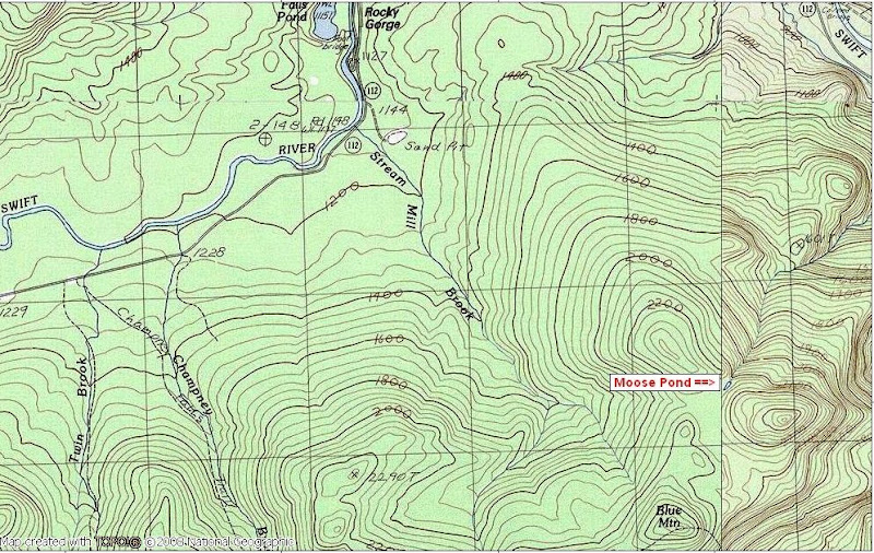
3) Where the heck is Moose Pond, some may ask? That question I can answer for you!
Although some maps don't include this little pond, it is in fact a named geographic feature.
The map below shows its location (almost due south of the Rocky Gorge Scenic Area on the Kanc).
Below is a photo taken from the north shore of this mini-pond looking southward toward Third Sister (see "P.S." note at end).
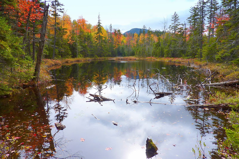 P.S. The mountain seen at the end of the pond was incorrectly identified as Mt. Blue in the text I originally posted.
It is actually Third Sister near Mt. Chocorua. Mt. Blue is nearby, but it is not the peak shown in the photo. I have Steve Smith to thank for providing the correct ID of this peak. Thanks again Steve!
But then I had difficulty deciding if it should be posted as a Trip Report, or as a Q&A.
Obviously, I decided to post it as a Q&A. So, here are my questions.
1) First of all, is anyone willing to admit to being so weird as to bushwhack to Moose Pond?
2)If there's anyone willing to admit to whacking to Moose Pond, are there any ledges with good views in the nearby vicinity?
I visited two ledges just a short distance above the pond to the NW, but neither provided any great photo-ops because of trees obstructing the view. Did I miss something that's worth going back to see? That would not be a problem since it's an easy bushwhack.
As my starting point I used the Steam Mill Brook valley (called Stream Mill Brook on some maps).
3) Where the heck is Moose Pond, some may ask? That question I can answer for you!
Although some maps don't include this little pond, it is in fact a named geographic feature.
The map below shows its location (almost due south of the Rocky Gorge Scenic Area on the Kanc).
Below is a photo taken from the north shore of this mini-pond looking southward toward Third Sister (see "P.S." note at end).
It is actually Third Sister near Mt. Chocorua. Mt. Blue is nearby, but it is not the peak shown in the photo. I have Steve Smith to thank for providing the correct ID of this peak. Thanks again Steve!
Last edited: