Summit signs taken down on the Carters

vftt.org

Help Support vftt.org:

This site may earn a commission from merchant affiliate links, including eBay, Amazon, and others.

Ed'n Lauky

Well-known member
Joined
Feb 15, 2007
Messages
1,802
Reaction score
168
Location
Blairsville GA ......... Avatar-- On top of S
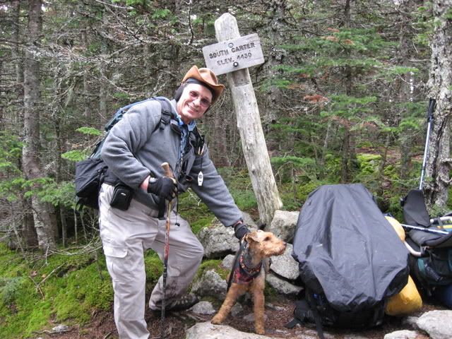
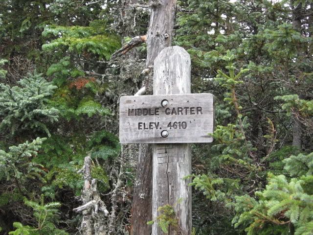
According to Wolfgang's trail report for the Carters on 10/4 a ranger was out taking down the summit signs on South and Middle Carter.

Does anybody know what is going on? Is there a policy of taking down all the summit signs? If so why? :confused:

I met Wolfgang at Zeta pass that day. We were going in opposite directions. The signs were still up when I went through so they must have come down right after we passed. For the nostalgic, here is what apparently is a last view of the two signs. This pictures would have been taken within an hour of their coming down. :(

IMG_0017.jpg


IMG_0015-6.jpg
 
That seems odd. The Wild River Wilderness starts east/below the ridgetop, right? So it wouldn't be Wilderness management....
 
I called the Andro ranger station and spoke with Justin, who informed me that:

Signs which are not required for public safety or resource protection are taken down as a matter of policy when the sign or the post supporting them is sufficiently deteriorated. They are not planning on replacing these signs.

North, Middle and South Carter signs are not required for public safety (no trail junction, cannot get lost) and as the high point on the trail is obvious, they aren't necessary for resource protection (avoid people wandering around looking for the high point.) All three of these signs are scheduled to come down when they are in bad enough shape.

(Were they in bad shape, and required for resource protection or public safety they would be replaced. When asked about leaving cairns on the summits he indicated that probably wasn't necessary for resource protection either, but didn't say one way or the other if they would build cairns or tear them down.)

Incidentally, he had heard about the discussion mentioned in the TR, and encouraged me to post this (also knew about VFTT) and encourages all to call with questions rather then engaging in speculation. I've called before for similar reasons and have always been given a polite and expedient answer.

Tim
 
bikehikeskifish said:
... and encourages all to call with questions rather then engaging in speculation. I've called before for similar reasons and have always been given a polite and expedient answer.
OK ... but speculation is MUCH more fun than "a polite and informed answer". What would we do here without speculation?????
 
Sheesh, if you are going to let your fingers do the walking, why do we even need the internet?
 
bikehikeskifish said:
I called the Andro ranger station and spoke with Justin, who informed me that:

Signs which are not required for public safety or resource protection are taken down as a matter of policy when the sign or the post supporting them is sufficiently deteriorated. They are not planning on replacing these signs.

North, Middle and South Carter signs are not required for public safety (no trail junction, cannot get lost) and as the high point on the trail is obvious, they aren't necessary for resource protection (avoid people wandering around looking for the high point.) All three of these signs are scheduled to come down when they are in bad enough shape.

(Were they in bad shape, and required for resource protection or public safety they would be replaced. When asked about leaving cairns on the summits he indicated that probably wasn't necessary for resource protection either, but didn't say one way or the other if they would build cairns or tear them down.)

Incidentally, he had heard about the discussion mentioned in the TR, and encouraged me to post this (also knew about VFTT) and encourages all to call with questions rather then engaging in speculation. I've called before for similar reasons and have always been given a polite and expedient answer.

Tim

OK, thanks for the effort in getting the explanation. I guess I have one followup question, are we allowed to discuss the policy or is that off limits?
 
Ed'n Lauky said:
OK, thanks for the effort in getting the explanation. I guess I have one followup question, are we allowed to discuss the policy or is that off limits?

Ditto, thank you, and let's assume that we are: gee, with all the real backlog in the forest, name your favorite project, is there really a ranger hiking around taking down dilapidated signs in non-wilderness areas? What does he do with them?
 
Post away.

The backcountry rangers are up there patrolling anyways. Taking inventory of signs and removing or replacing as needed seems right in line with their jobs.
 
bikehikeskifish said:
...Signs which are not required for public safety or resource protection are taken down as a matter of policy when the sign or the post supporting them is sufficiently deteriorated. They are not planning on replacing these signs.

Thanks for taking the time to call them.

That's an interesting policy - I wonder if they've thought it thru? For example, the sign on the summit of Adams is quite unnecessary, in a way. After all, there's little doubt that that you're on the summit of something. The same could be true with Washington. After all, how could you not know where you are? My hunch is the post supporting the sign on Washington will be repaired until Time Eternal.

But ... it's a little different when you're traipsing along a ridge with lots of little PUDs in them, like Middle and South Carter. It's not quite as obvious which is the high point. If it's your first time, and you approach them from Zeta Pass, then you might wander past Middle wondering if you've actually made it. Then, when you spot N. Carter ... maybe that one's really Middle?
 
The summit of Adams is a trail junction. You need signs up there anyways. Same with Madison. Along the Carters ridge there's no trail junctions at the summit, and those signs don't help anyone with directions. I'm not saying that I totally agree with the policy, but I understand it.

Peakbagging doesn't yet rank up there as an important a pastime as navigation does. At least that's my interpretation.
 
David Metsky said:
Peakbagging doesn't yet rank up there as an important a pastime as navigation does. At least that's my interpretation.
However, if you are doing an out-and-back to a summit, then the summit is is a navigation point. Or deciding whether to continue or turn back.

Doug
 
If the purpose of the summit signs is reduced to navigation, and using Dave's logic, then several could be removed. The Twins, Galehead, Hancocks and Zealand come immediately to mind. Am sure there are others (maybe Cabot, for example?)
 
DougPaul said:
However, if you are doing an out-and-back to a summit, then the summit is is a navigation point. Or deciding whether to continue or turn back.

Doug

But in line with attaining the summit - that sounds like a non-goal for the signs. A cairn may be appropriate in that case. You can't get lost, however - just turn around.

Tim
 
Kevin Rooney said:
If the purpose of the summit signs is reduced to navigation, and using Dave's logic, then several could be removed. The Twins, Galehead, Hancocks and Zealand come immediately to mind. Am sure there are others (maybe Cabot, for example?)

He told me that he has upwards of 1000 signs in his sign log that they routinely check on while patrolling. He even offered to check exactly which sign(s) were taken down from the Carters - although he believed it was only one. It could well be that when those signs you mention are in need of repair, then they will disappear.

Zealand, I think, is not an official sign, is it? It doesn't have RMC, DOC, AMC, or USFS on it.

Tim
p.s. I'd guess South Carter since that one is leaning over quite a bit, although the sign isn't rotten and the post looks sturdy, albeit tipped.
 
bikehikeskifish said:
But in line with attaining the summit - that sounds like a non-goal for the signs. A cairn may be appropriate in that case. You can't get lost, however - just turn around.
The ridge is treed and cairns can be buried by snow. If cairns are also used to mark a route, then distinguishing between a route cairn and a summit cairn can become a problem.

We may end up with a situation like Owls Head--some people feel the need to redo it because they weren't sure if they attained the true summit unless they did a full traverse. And IIRC, the true summit is just off the trail so the really obsessive peakbaggers won't know where to step off the trail. :)

At the rate things are going the only way to verify that one is on a summit may be a GPS or compass bearings from other peaks...

Doug
 
I was up there today. The sign for North Carter is still there. Middle Carter is gone but there is a cairn. Didn't make it to South Carter.
 
Some hikers consider signs an amenity to take photos with, the NH AMC newsletter had an article requesting signs on all 4k peaks.

This trail is the AT hence could be expected to have more amenities, somebody needs to check what the AT mgt plan says.
 
Top