1HappyHiker
Well-known member
Have you ever done something that is difficult to explain to someone, including yourself? For example, have you ever headed into the woods with merely a sketchy idea as to where you might go? It's rare that I embark upon a hike with a wishy-washy game plan, but that is what I did on this late autumn day of 28-Oct-2011.
Depending upon how much time remained after finishing up some errands in the Gorham area, I had in mind that I'd do a hike of some sort. With less than 5 hours of daylight remaining, I pulled into the huge parking lot at the Appalachia trailhead. I had my choice of parking spots since only three other cars were there!
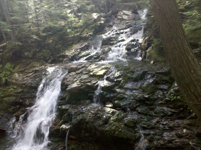
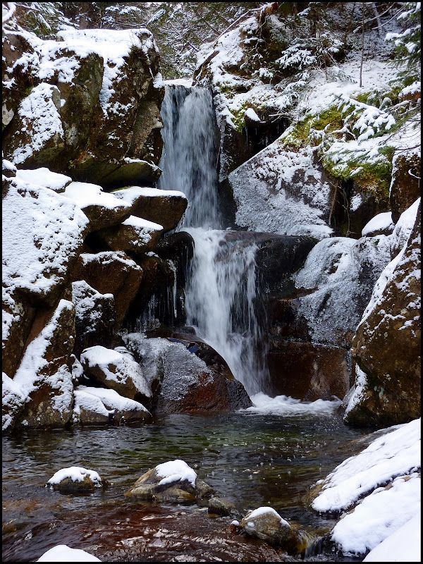
Now that I'd arrived at a trailhead, it was time to formulate some semblance of a plan! One thing I knew for certain was that the high peaks would be excluded from today's agenda. Not only wasn't there enough time, but also I didn't have the proper equipment with me for this type of adventure at this time of year. After some quick deliberation, I opted to begin my hike on the Brookbank Trail since that was a trail that I'd never hiked. This route traverses the east bank of Snyder Brook and leads you to three named waterfalls, i.e. Gordon, Salroc, and Tama. Of those three, the best photos I got were of Gordon and Tama which are shown below.
Gordon Fall
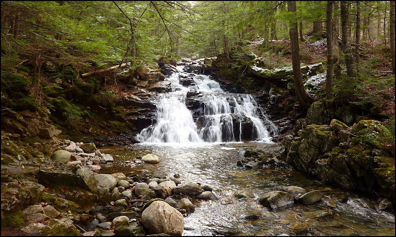
Tama Fall
Once the Brookbank Trail ended above Tama Falls, I decided to jump onto the Valley Way and head southward, but there was still no firm game plan in mind. Upon coming to the junction where I could head eastward onto the Inlook Trail, I decided to take that option. January 2009 was the last time I'd been on this trail, and so it seemed like a good time to make a return visit. And besides, if I wasn't going to the high peaks today, at least I could get a look at Mts. Madison and Adams from the ledges at the upper end of this trail.
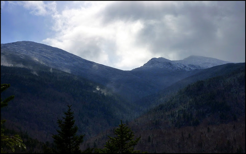
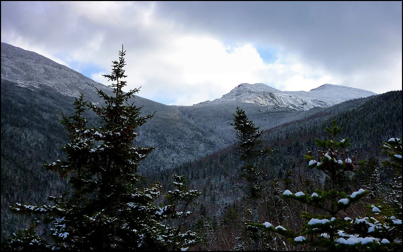
The weather forecast called for mostly sunny blue skies, but that didn't quite happen in the heavens above the high peaks in the northern Presidential Range. Instead, the sky was predominately overcast and moody. Also, there were gusty winds, not only at the ledges along the Inlook Trail, but certainly at the higher elevations as well. The plumes of white that are seen in the next photo were caused by the wind tossing snow into the air. That is not mist arising from the mountains!
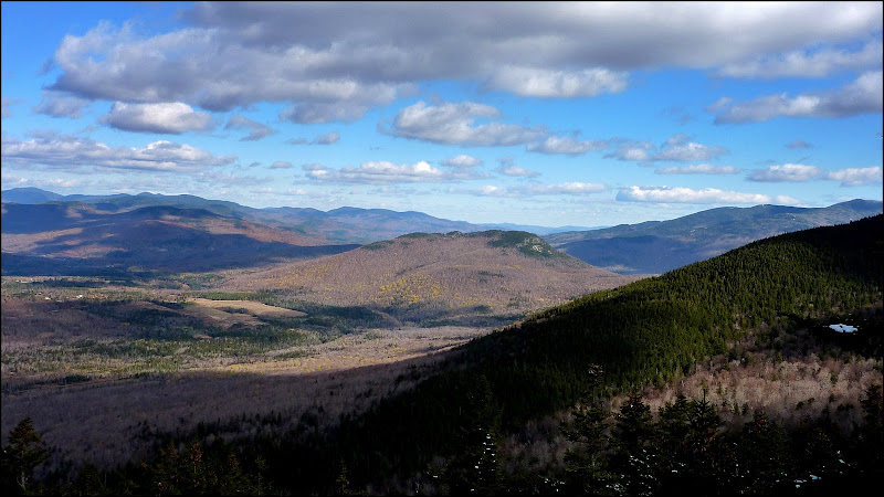
After visiting the ledges on the Outlook Trail, I rambled over to Dome Rock to take in the views toward the Crescent Range and the Mahoosucs. From here, the vista left little doubt that the colorful scenes of autumn are gone, disappeared, vanished . . . however you want to say it! What many call "stick season" is now here with all its muted shades of tan and brown (next photo).
Well, since I still had a few hours of daylight remaining, I opted to continue onward from Dome Rock by taking the Kelton Trail southward with the thought of eventually working my way to a waterfall I'd never visited, i.e. Duck Fall (located at the point where the Watson Path crosses Snyder Brook). It was a relatively short and easy trek to get to this spot. Although this waterfall was attractive, it was, how shall we say it . . . small!
By now it was getting late in the day, and I so I decided it was time to start meandering northward back to the trailhead. I retraced my steps along the Watson Path and followed it to the junction with the Valley Way. I stopped here to consider if I should simply end my wandering journey and head directly for the trailhead, or embark upon another short sidetrack adventure. It occurred to me that during all my treks in the northern Presidentials, I'd never taken the time to visit the Durand Scar. Since it was just a short distance away, the decision was made to go for it! And so, I crossed over the Valley Way and continued on the Watson Path to the Scar Trail, and then took the Scar Loop Trail.
From the Scar Loop Trail I got another nice view of Mts. Madison and Adams that was similar to the vista I'd seen earlier in the day from the ledges on the Inlook Trail. However, by this time the gusty winds had subsided and the plumes of wind-driven snow were no longer seen. The next snapshot shows a vista from the Scar Loop Trail.
Okay, after visiting the Durand Scar, it was definitely time to skedaddle back to the trailhead. From the Scar Trail, I joined the Valley Way and followed it for quite some distance. But, merely for the sake of doing one last thing that was just a little bit different, I decided to leave the Valley Way and use the combination of the Beechwood Way and Airline Trail as the final approach to the trailhead.
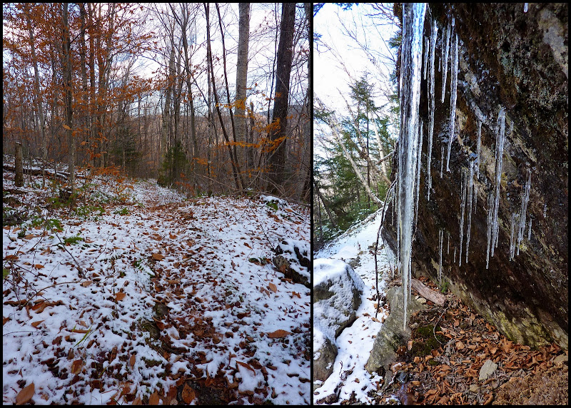
All along my route, there were definite signs of the approaching winter season, such as trailside icicles, and a light coating of snow underfoot (next photo).
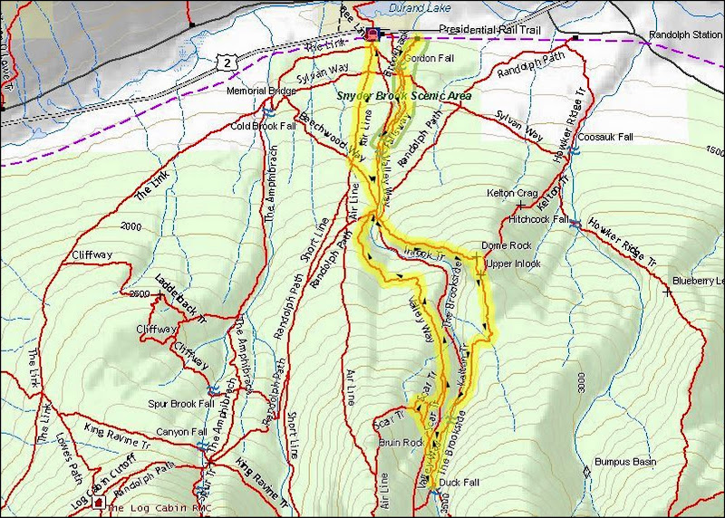
Speaking of my route, it's doubtful that anyone would want to replicate it. However, for anyone who might have a passing interest or curiosity, my route is highlighted on the map that is shown below. As can be seen, I ended up doing sort of an elongated "figure 8" loop hike, which covered a distance of about 6 miles.
To sum it up, although this wasn't a well-planned hike, it was still an enjoyable romp in the woods, and it provided an opportunity to visit a few spots that were new to me. This unplanned and meandering trek was largely enabled by the Randolph Mountain Club's vast network of interconnecting trails. When hiking their trail system, rarely can it be said that "you can't get there from here"!")
Depending upon how much time remained after finishing up some errands in the Gorham area, I had in mind that I'd do a hike of some sort. With less than 5 hours of daylight remaining, I pulled into the huge parking lot at the Appalachia trailhead. I had my choice of parking spots since only three other cars were there!
Now that I'd arrived at a trailhead, it was time to formulate some semblance of a plan! One thing I knew for certain was that the high peaks would be excluded from today's agenda. Not only wasn't there enough time, but also I didn't have the proper equipment with me for this type of adventure at this time of year. After some quick deliberation, I opted to begin my hike on the Brookbank Trail since that was a trail that I'd never hiked. This route traverses the east bank of Snyder Brook and leads you to three named waterfalls, i.e. Gordon, Salroc, and Tama. Of those three, the best photos I got were of Gordon and Tama which are shown below.
Gordon Fall
Tama Fall
Once the Brookbank Trail ended above Tama Falls, I decided to jump onto the Valley Way and head southward, but there was still no firm game plan in mind. Upon coming to the junction where I could head eastward onto the Inlook Trail, I decided to take that option. January 2009 was the last time I'd been on this trail, and so it seemed like a good time to make a return visit. And besides, if I wasn't going to the high peaks today, at least I could get a look at Mts. Madison and Adams from the ledges at the upper end of this trail.
The weather forecast called for mostly sunny blue skies, but that didn't quite happen in the heavens above the high peaks in the northern Presidential Range. Instead, the sky was predominately overcast and moody. Also, there were gusty winds, not only at the ledges along the Inlook Trail, but certainly at the higher elevations as well. The plumes of white that are seen in the next photo were caused by the wind tossing snow into the air. That is not mist arising from the mountains!
After visiting the ledges on the Outlook Trail, I rambled over to Dome Rock to take in the views toward the Crescent Range and the Mahoosucs. From here, the vista left little doubt that the colorful scenes of autumn are gone, disappeared, vanished . . . however you want to say it! What many call "stick season" is now here with all its muted shades of tan and brown (next photo).
Well, since I still had a few hours of daylight remaining, I opted to continue onward from Dome Rock by taking the Kelton Trail southward with the thought of eventually working my way to a waterfall I'd never visited, i.e. Duck Fall (located at the point where the Watson Path crosses Snyder Brook). It was a relatively short and easy trek to get to this spot. Although this waterfall was attractive, it was, how shall we say it . . . small!
By now it was getting late in the day, and I so I decided it was time to start meandering northward back to the trailhead. I retraced my steps along the Watson Path and followed it to the junction with the Valley Way. I stopped here to consider if I should simply end my wandering journey and head directly for the trailhead, or embark upon another short sidetrack adventure. It occurred to me that during all my treks in the northern Presidentials, I'd never taken the time to visit the Durand Scar. Since it was just a short distance away, the decision was made to go for it! And so, I crossed over the Valley Way and continued on the Watson Path to the Scar Trail, and then took the Scar Loop Trail.
From the Scar Loop Trail I got another nice view of Mts. Madison and Adams that was similar to the vista I'd seen earlier in the day from the ledges on the Inlook Trail. However, by this time the gusty winds had subsided and the plumes of wind-driven snow were no longer seen. The next snapshot shows a vista from the Scar Loop Trail.
Okay, after visiting the Durand Scar, it was definitely time to skedaddle back to the trailhead. From the Scar Trail, I joined the Valley Way and followed it for quite some distance. But, merely for the sake of doing one last thing that was just a little bit different, I decided to leave the Valley Way and use the combination of the Beechwood Way and Airline Trail as the final approach to the trailhead.
All along my route, there were definite signs of the approaching winter season, such as trailside icicles, and a light coating of snow underfoot (next photo).
Speaking of my route, it's doubtful that anyone would want to replicate it. However, for anyone who might have a passing interest or curiosity, my route is highlighted on the map that is shown below. As can be seen, I ended up doing sort of an elongated "figure 8" loop hike, which covered a distance of about 6 miles.
To sum it up, although this wasn't a well-planned hike, it was still an enjoyable romp in the woods, and it provided an opportunity to visit a few spots that were new to me. This unplanned and meandering trek was largely enabled by the Randolph Mountain Club's vast network of interconnecting trails. When hiking their trail system, rarely can it be said that "you can't get there from here"!
Last edited: