I'd like to hike Mt Wash this Thursday but the forecast right now is "Very windy, with a northwest wind 38 to 43 mph decreasing to 29 to 34 mph in the afternoon." I was planning to hike up the Ammonoosuc Ravine Trail and return on Jewell. I don't mind strong winds but I've never measured wind so I have no calibration for it. Would you hike with this prediction on these trails?

You are using an out of date browser. It may not display this or other websites correctly.
You should upgrade or use an alternative browser.
You should upgrade or use an alternative browser.
How Windy is too Windy - Mt Washington
- Thread starter BethW
- Start date
Help Support vftt.org:
This site may earn a commission from merchant affiliate
links, including eBay, Amazon, and others.
grouseking
Well-known member
I'd like to hike Mt Wash this Thursday but the forecast right now is "Very windy, with a northwest wind 38 to 43 mph decreasing to 29 to 34 mph in the afternoon." I was planning to hike up the Ammonoosuc Ravine Trail and return on Jewell. I don't mind strong winds but I've never measured wind so I have no calibration for it. Would you hike with this prediction on these trails?
Peronally, I would hike with winds of that speed, as long as the visibility is excellent, and temps comfortable. Wind gusts to 40 mph might stop you for a little bit, but it shouldn't cause you to have to turn around. Those winds sound like a normal blustery day above treeline. You will be in the winds for most of that trip above treeline, esp as you head down Washington toward the Jewell trail.
Those point and click forecasts for the national weather service are geared towards describing conditions at sea level, or where the vast majority of people live. Winds to 40 mph where you or I live is very windy...on Mt Washington, not so much. I'd check with the Mt Washington observatory forecast Wed, and then again Thursday morning before setting out. Hope that helped!
Thanks for the reality check. I will check out the Mt Washington observatory forecast. So noaa doesn't get their Mt Wash data from the observatory folks? I don't want to jinx myself but my favorite hikes have been in big winds - it's a thrill as long as I'm warm.
The NOAA computer model forecast is designed to be generally accurate for T+36 hours. Beyond that, the variables aren't as well known and the forecast accuracy drops way off. The Mount Washington Observatory only forecasts 36 hours out - too hard to predict otherwise.
NOAA Mt Washington Point Forecast
NOAA Recreational Forecast
OBS Forecast
Here is a discussion with Ryan Knapp, a MBO meteorologist that some may find enlightening.
Tim
NOAA Mt Washington Point Forecast
NOAA Recreational Forecast
OBS Forecast
Here is a discussion with Ryan Knapp, a MBO meteorologist that some may find enlightening.
Tim
Last edited:
The route selected is somewhat sheltered going up to Lake of the Clouds but very soon after LOC, the wind exposure increases substantially. I have many times walked up to LOC in minimal fall gear and had to switch to full winter gear within a 15 minute period of time while heading up Crawford path from the hut. The walk over to Jewell from the summit is entirely exposed and you will be walking directly into the wind with no good options to bail for at least an hour. There is a distinct possibility you will get blown off your feet or lose your balance on occasion. The terrain is rocky and in many places requires rock hopping, so an unexpected gust may cause your foot to land in a hole instead of on nearby rock.
At a minimum, you will need full coverage for clothing, this means windproof jacket and pants, facemask, and gloves and appropriate insulating layers.
If you are willing to just do a lake of the clouds hut hike and be willing to call it a day if the windspeed doesnt drop, go for it but if you want to summit at all costs then come visit another day. Even if the wind does drop for awhile, it may come back. This time of year, there are many folks who "roll the dice" and get stuck at the summit asking for a ride down the autoroad. If the autoroad is running, they will try to accomodate the folks but it could be $100 each for the privilege depending on the time of day.
There is a lot to be said for picking a summit with less wind exposure. Osseo trail up Flume is great for a windy day as its sheltered from NW winds and goes through some nice hardwood forests. High Cannon trail up Mt Cannon has great views and plenty of protection from the wind. Alternatively the hike up Tuckermans from Pinkham offers a lot of shelter until you hit the top of the ravine and it has some shelter from the NW, the trade off is that taking Lions Head down has a lot of exposure.
Thanks for all the information. If I do this I will certainly bring all the gear. I'd love to do Tuckerman's but I've sort of blown my knees climbing mountains this summer (another topic to post) and was hoping for gentler grades. Rock hopping on Jewell is not an option in the best of weather, so thanks for that info. It would be out and back on Ammonoosuc then. How rough is Tuckerman's in terms of descent? I'd be willing to do an out and back on that as well. I'm also fine with turning around if necessary.
teleskier
New member
- Joined
- Sep 18, 2003
- Messages
- 152
- Reaction score
- 16
I'll just pass along our experience from just before Labor Day FWIW. My wife and I were doing a presidential range traverse from north to south with nights at Madison Springs and Lakes huts. The first day, the forecast (for the mountain summits) was winds in the 50-70 mph range. We got jostled a bit on Madison, but were basically able to hike it without getting knocked down. I'm notoriously bad at estimating wind speeds, but I seriously doubt it was much over 50.
Starting out the second morning, the forecast (summits) was for 60-80 mph winds with higher gusts. We debated about what to do - we'd have to cross Adams, Jefferson and Washington to make Lakes hut - and decided we would give Adams a go, see how things were, and retreat to Madison hut and abort if worse came to worse. Adams was no worse than Madison the day before, Jefferson was better, and Washington was about like Adams only more unpleasant due to rain - but we knew we had the safety of the summit building to take advantage of. Again, got jostled a bit on Washington, but certainly could hike it, and made it to Lakes hut nicely.
After getting out and getting online, I discovered that the peak wind gust on Mt Washington that day was indeed 85mph, but certainly we experienced considerably less than that. My point is that even starting out at elevation, with a forecast that was only an hour or two old, we found considerable variation from that forecast as we hiked during the day. And, of course, we were prepared to retreat off the mountain if necessary and abort the trip. I guess that's my way of saying if it were me, I'd give it a go, and re-evaluate the situation when I got to treeline. And, keep in mind, there is the chance to re-group at the summit building if you can get there.
Its highly subjective but to me Tuckermans up the headwall is easier than Ammonusuc ravine trail. The approach to Hermit Lake is relatively steady grade on the Tucks trail and you end up at higher elevation than the pool on Ammo where the trail start up the steep ascent to LOC. Tucks from Hermit Lake to the top of the headwall trail has been extensively rebuilt over the years and has great footing even up the headwall. Tucks does loose out climbing the summit cone as it is more a rock hop than Crawford Path but the decreased wind is going balance out some of the advantages of Crawford path. Realistically either Ammo or Tucks is bear on the knees. Jewel is better as its less steep once you hit treeline but the tradeoff is its a lot longer.
Last edited:
carla
Member
Ammo up and back?
Just putting my two cents in here. I much prefer doing the Ammo up, Jewell back route. Yes, Jewell can be hard on the knees but I think that's preferable to very steep and wet descents on the slabs going back down Ammo. Plus, the views as you head down to the Jewell trail are really spectacular and not be be missed.
--Carla
DougPaul
Well-known member
I'd go up Tuckerman's and down Lion's Head--steep up is easier on the knees than steep down. Both are on the "somewhat" protected east side. (The prevailing winds are from the west, but of course can come from any direction at any specific moment.)How rough is Tuckerman's in terms of descent?
Re wind speed: at ~80mph, the wind can lift you up and send you flying. (Crawling or moving between gusts may be the only options at such wind speeds...) The Beaufort Scale may give you a better idea of wind speed vs effects: http://en.wikipedia.org/wiki/Beaufort_scale
The force of the wind increases with the square of its speed.
If you are not sure about your ability to handle strong winds, I'd suggest that you wait for a relatively calm day. Also the wind on that mountain often increases dramatically near the summit so if it becomes threatening lower down, consider turning around and coming back another day.
Most of the commonly used hiking routes up Mt Washington are >=4mi and 4000 vert ft, so none are easy on the knees...
Doug
Last edited:
nartreb
Well-known member
A peak gust speed of 55mph will definitely provide an adventure, but it's not really dangerous if you're well covered against frostbite and you're prepared for navigation in the fog. (Summit high temperature forecast: mid thirties. That's before wind chill.) You may have trouble walking normally, but you'll probably get used to it. You won't be tempted to crawl until the wind reaches hurricane strength - low 70s mph. By 90 mph, you're in danger of being lifted off your feet. But winds of 40-50mph are no reason to stay home.
I find that the Lion's Head is often just as windy as the summit, even when the wind is from the west and you'd think the LH would be in the lee of the summit. The Lion's Head/Tuckerman ravine route also is a tough one on foggy days - if you lose the trail on the way down, you have a major terrain problem: the headwall of Tuckerman ravine. My first choice with a strong NW wind would be to go up Ammo - the wind will lift you on the way up. Go down Jewell if you can handle walking straight into the wind for a while, else go down Ammo. (Edit, didn't see the comment about the knees. I don't recall Jewell being tough on the knees, but I did it in winter.)
I find that the Lion's Head is often just as windy as the summit, even when the wind is from the west and you'd think the LH would be in the lee of the summit. The Lion's Head/Tuckerman ravine route also is a tough one on foggy days - if you lose the trail on the way down, you have a major terrain problem: the headwall of Tuckerman ravine. My first choice with a strong NW wind would be to go up Ammo - the wind will lift you on the way up. Go down Jewell if you can handle walking straight into the wind for a while, else go down Ammo. (Edit, didn't see the comment about the knees. I don't recall Jewell being tough on the knees, but I did it in winter.)
Last edited:
roadtripper
Well-known member
My personal limit is sustained winds of 50mph or gusts of up to 60mph. I did Washington once when it had 65-70mph gusts and it forced me to trip and fall two or three times near the summit.
Driver8
New member
- Joined
- Aug 13, 2012
- Messages
- 779
- Reaction score
- 0
I'd go up Tuckerman's and down Lion's Head--steep up is easier on the knees than steep down. Both are on the "somewhat" protected east side. (The prevailing winds are from the west, but of course can come from any direction at any specific moment.)
I'd much rather go up Lion Head and down Tuck's. Or just go up and down Tuck's - it's so beautiful that it would absolutely reward the there-and-back trip. Ammo is much rougher on descent than would be Tuckerman - I did Ammo up to the hut and back May 12, a day where the gusts from a couple hundred feet below the hut and above were 70 mph in the 3:30-4:30 pm hour when I was there, with steady winds at 50. That definitely is too windy, and bear in mind the forecast for that day, beforehand, was similar to the forecast the OP now is looking at, so those winds can easily bump up a lot higher than forecast, even if the sky is blue and beautiful, partly cloudy as it was 5/12. (The Mt. Washington Observatory's recordings for the 4 pm hour, iirc, were of steady 70 mph winds with gusts to 86. Windiest day of May, and I reached the hut, as it happened, at the windiest time.
") )
)Ammo is a very tough, rough descent, but doable if you are suffciently well conditioned and take the care and time needed. I did Jewell up and Ammo down, with the A.T. links in between on a nigh-windless day 6/17. That was amazing. Ammo on descent that day, as tired as I was, testing the limits of my strength and stamina, was very difficult and mentally taxing, venturing seriatim a knee or ankle blow-out or broken leg. It was harder than I remembered from the month before, even though dry in June where it had been wet and snowy/icy for the highest 1000 feet or so in May - traction had made a big difference.
Went up Tuckerman and down Lion Head July 22. Tuckerman was steep but very well constructed along the main headwall, and the views were amazing. It was a beautiful climb and would be a very pretty descent, forgiving, relatively speaking, on knees and ankles. Lion Head, at the end of my biggest single day elevation gain, was brutal, especially the mile or so descending from the head of the lion to the Tuckerman trail. Definitely knee blow-out territory, if anything worse than Ammo. Ascending it would be much better - it is quite pretty and would be a fun challenge to scramble up.
My recommendation to the OP, to minimize wind exposure, maximize enjoyment and spare the knees and ankles as best possible? Go up Lion Head and down Tuckerman. Or if that idea makes you a bit anxious, then eliminate the fear of Tuck's by going up it and seeing how relatively easy it is - no kidding - and then go back down it. But given your concern for knees and such, give careful thought to going down Lion Head or Ammo, especially if you don't go up them first. They are doable, but daunting.
Another possibility - go up Ammo, cross over to Tuck's to get wind shielding, then up to W and down via the Cog if the winds are too much. Jewell is, as trail, relatively easy b/c its grades are pretty steady. Footing can be tough above tree-line on it and on the A.T. routing, as others have noted, but the views are spectacular.
Bear in mind that climbing the summit cone above Tuckerman's junction, while breathtakingly pretty, is a strong workout in itself. I found it harder than the headwall, though that probably had something to do with tiring after doing the headwall. The cone was easier on descent than I expected and got much rougher once I took the left turn onto Lion Head Trail, which is easy only for the short stretch from the Alpine Garden junction to the Head and for the brief bits on either end near Tuckerman Ravine Trail. The rest of it is quite rough with little relent.
Whichever way you go, it's beautiful, but approaching from the east is nicer when the west winds are strong, and there's no reason to choose Ammo over Tuck's on account of knees and ankles, in my experience.
Last edited:
Driver8
New member
- Joined
- Aug 13, 2012
- Messages
- 779
- Reaction score
- 0
Thanks for the reality check. I will check out the Mt Washington observatory forecast. So noaa doesn't get their Mt Wash data from the observatory folks? I don't want to jinx myself but my favorite hikes have been in big winds - it's a thrill as long as I'm warm.
MountWashington.org is a superb site in its own right worth many a visit.
Just for info, the Mt Washington Auto Road Hiker Shuttle page :
http://mtwashingtonautoroad.com/start-your-adventure/hiker-shuttle/
Breeze
http://mtwashingtonautoroad.com/start-your-adventure/hiker-shuttle/
Breeze
Kevin Judy and Emma
Well-known member
THIS is too windy...
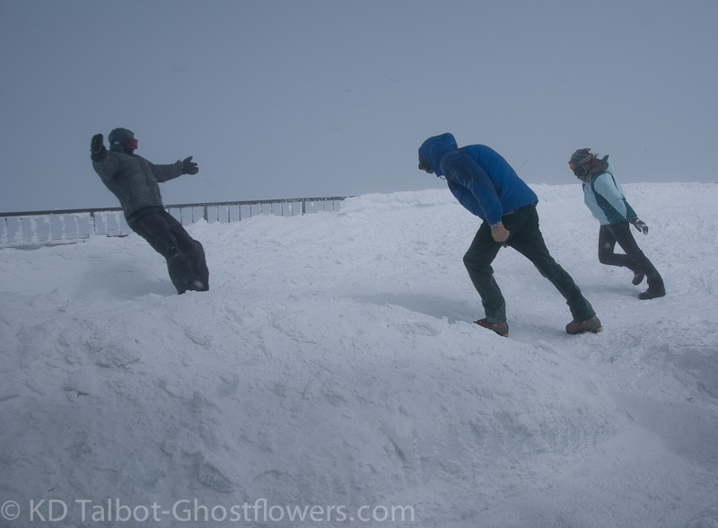
The photo and video are taken on the deck of the Sherman Adams Building on the summit of Mount Washington. The guy on the left is average size and did not fall backwards. The guy in the middle is 6'4 220lbs and could make little headway. The girl on the right got blown down and had to crawl back to the lee of the building. The wind was 55 with a gust to 65mph. They had no packs which basically act as sails...
I am 5'11 210lbs. This is me in sustained 80mph with a gust to 86. As the wind increases the pressure on your body surface grows incrementally. I'm not a scientist and can't explain this phenomenon, but I'm sure there are some here who can... 8 )
Video HERE:
KDT
John in NH
Member
I find hikers often exaggerate wind speed when in the field. Since being able to look at a wind gauge while hiking, I realized I too would overestimate my off the cuff guesses. What I swore was 45 mph usually turned out to be 30 mph. This summer on Adam’s we were in 40-45mph winds and I encountered a hiker who said the winds were over 70 mph and that he knew because he had been in hurricanes. Last Saturday I was on jefferson when washington was getting 62mph gusts and it was forcing me to crouch and I bagged plans to continue to Adams.
As far what’s too much, Kevin’s posted picture says a lot. Above 60 mph really is too much to hike effectively, you be slowed, knocked off balance, and have to resort to crouching sometimes. If the temps are above 40, then 55 would my personal limit, unless I was thinking about doing multiple presi peaks, then my cutoff would be 45-50mph. If it colder, 30’s or below, then the windchill factors really kick in and I would say 40. Even with face protection and clothing its really draining to be below freezing winds. Much easier to pick a different hike below treeline or different day.
As far what’s too much, Kevin’s posted picture says a lot. Above 60 mph really is too much to hike effectively, you be slowed, knocked off balance, and have to resort to crouching sometimes. If the temps are above 40, then 55 would my personal limit, unless I was thinking about doing multiple presi peaks, then my cutoff would be 45-50mph. If it colder, 30’s or below, then the windchill factors really kick in and I would say 40. Even with face protection and clothing its really draining to be below freezing winds. Much easier to pick a different hike below treeline or different day.
Driver8
New member
- Joined
- Aug 13, 2012
- Messages
- 779
- Reaction score
- 0
As far what’s too much, Kevin’s posted picture says a lot. Above 60 mph really is too much to hike effectively, you be slowed, knocked off balance, and have to resort to crouching sometimes.
I've only hiked in high winds, above 35 sustained, that one day up Ammo, and I got knocked off my feet twice in the last 100 yards before the hut. Hid behind it for a while and checked on the winds by peeking around the southwestern corner, quickly to be converted into a balloon but not quite a kite, ducking back for cover for a bit. I was able to get up Crawford Path to the Monroe Loop junction to take some pics, stumbling a few times until I got behind Monroe's cone and shielded a bit from the NW winds. Funny thing was, by the time I got back down to about 4500', the winds had fallen below 10 mph for the most part, though, per the Obs, the high winds up top continued to howl into that night. Will-o'-the-wisp.
Last edited:
RoySwkr
New member
- Joined
- Sep 4, 2003
- Messages
- 4,467
- Reaction score
- 285
I think you would find hiking in a sustained wind like this very tiring and hard to breathe in, with as mentioned the possibility of injury from being blown overnorthwest wind 38 to 43 mph decreasing to 29 to 34 mph in the afternoon
However I believe the wind in the forecast to be the peak wind expected, with most of the day being less, so if you like wind it might be just the day for you
Red Oak
New member
http://www.mountwashington.org/weather/summit_forecast.php
Wind seems like it will not be that bad,but the wind chills could be another story, if you are not really into winter hiking.Full winter gear today,most def some shell and face protection needed up top.Have fun!Perfect conditions imho
Wind seems like it will not be that bad,but the wind chills could be another story, if you are not really into winter hiking.Full winter gear today,most def some shell and face protection needed up top.Have fun!Perfect conditions imho
Similar threads
- Replies
- 15
- Views
- 2K