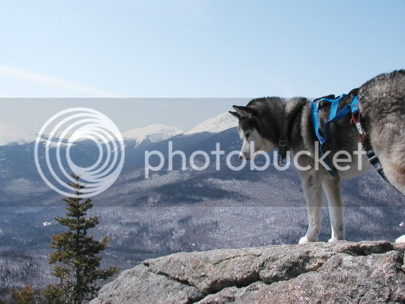
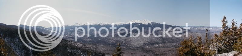
I have been told the Imp Face (along the north spur of the Imp Trail) has a spectacular view - the day I was there had about 50 foot visibility - straight into the fog.
There are many limited views heading towards Zeta Pass after you get on the ridge via the North Carter Trail - I have not headed in the direction towards the shelter.
North Branch is the best choice for views on Imp Face & a nice walk below, some of it along a brook.
South branch near the junction with North Carter Trail is in the brook & down low is a slog, if you can call a 1.6 mile or so trail a slog. Only advantage South has is that you can bushwhack from it to Camp Doge or 19 Mile Trailhead so a one car loop can be done.
I think some folks might be a bit confused by this one. The Imp trail does not go up to Imp shelter (although some folks have tried!). It makes a loop that starts and ends at Rt 16. The North section of the trail has some obscure views looking north prior to Imp Face (which has a great view). South of the Face, there are some additional obscured views on occasion until the junction with the North Carter trail. The rest of the Imp trail back to RT 16 is mostly viewless. To get to Imp shelter, take the North Carter trail to the Carter Moriah Trail and head south down over North Carter (a very steep climb) and eventually you will come out at the Imp shelter spur.
The fastest way to Imp shelter is up Stony Brook trail to the Carter Moriah Trail then head south. This cuts out the major elevation gain and loss for North Carter.
Thank you for noting this. I too was confusing the Stony Brook trail for the Imp trail. This is for sa group of older Boy Scouts as an overnighter and i want them to enjoy a good view. Stony Brook in and Imp trail out might be better than Moriah as I look at it now. The trip is planned for the end of April, I'll may hike it myself the week before to check out trail conditions.
To get to Imp shelter, take the North Carter trail to the Carter Moriah Trail and head south down over North Carter (a very steep climb) and eventually you will come out at the Imp shelter spur.
The fastest way to Imp shelter is up Stony Brook trail to the Carter Moriah Trail then head south. This cuts out the major elevation gain and loss for North Carter.
Small correction, after reaching the Carter-Moriah Tr. head NORTH up and over North Carter. The decent down N. Carter is very steep indeed. The Stony Brook Tr. is a nice walk in the woods with no real open views I can remember.
We usually do these trips even earlier in April (6 patrols in different locations), it's good training on packing right and traveling right, as the wrong gear and horseplay on the trail will leave them uncomfortable (but not in danger) and wiser. This route is for our more seasoned Scouts as well as a shake down for Philmont.
Anyone now the distance between the Stony brook Lot & the North End of the Imp trail? (I assumed you knew way to the Shelter) Very wet unless cold up at junction of Stony Brook & CM trail then maybe icy. Steep climb (reversing Peakbagger's directions but keeping his south direction) up North Carter from shelter which may be icy since it's the north face & gets little sun.
Going the week before a good idea. I'd also think about a trip with a more southern expsoure so you get some benefit of the sun melting the trail. Some years there can be feet of snow still left in April above 3,000 feet.
Thanks Tom & Atticus. What I meant though was the road walk portion of it from the North Imp back to the lot. Bringing the bike up at some point for those not quite a loop "loop hikes"
BTW it was nice meeting you in Steve's shop back on March 9th.
Thanks Tom & Atticus. What I meant though was the road walk portion of it from the North Imp back to the lot. Bringing the bike up at some point for those not quite a loop "loop hikes"
BTW it was nice meeting you in Steve's shop back on March 9th.
I did that exactly. Parked uphill at Imp north TH, cruised down to the lot at Stoney Brook and stashed the bike in the woods. I found it to be a very easy bike ride
Thanks Tom & Atticus. What I meant though was the road walk portion of it from the North Imp back to the lot. Bringing the bike up at some point for those not quite a loop "loop hikes"
Can't be more than 3 miles, and nearly all downhill. As Rocks says a VERY easy ride (but I've always started that "loop" hike at Stony Brook, and would stash the bike at Imp trail in the woods)
North Carter will be very icy in April, and a tough go. IIMHO, you'd be better off taking Carter Moriah up from Gorham (from Bangor Rd). You will get nice views on Mt Surprise, and then a ton of great views of the Presis and Carters heading over from Moriah to the shelter. Besides, you might as well start training the new peak baggers
Although this is a bit off-topic, it’s still related. Many have probably seen the profile view of the Imp Face from the Dolly Copp Campground. But for anyone who has not, you might be interested in the photos at the link below: http://outdoors.webshots.com/album/558432446xFJIBR
The photos were taken in early autumn. You need to enlarge them to 100% to get the full effect.

")