
1HappyHiker
Well-known member
When going on a hike, it's a common practice to head off toward a destination (mountain, pond, waterfall, etc) that has been given a name and appears on map. However, one of the most liberating things I've learned is that a destination doesn't necessarily need to be a named feature on a map. For example, there is no rule that obliges one to hike a trail all the way to the top of a mountain. There is complete freedom to choose a particularly nice spot that is located anywhere along a trail and let that be your final destination. And, for hikers who enjoy off-trail travel, a final destination might involve bushwhacking to a nameless peak or pond.
Several nameless destinations near Mt. Moriah were the focus of a recent adventure undertaken by my friend Steve and me on a sunny February day when the air temperature never rose above freezing! However, there was a time back around 1895 when the temperature in this area was sizzling as a raging forest fire consumed over 4,000 acres in the Moriah Brook Valley and along the southeastern ridge of Mt. Moriah. Fires such as this cause tragic losses to flora and fauna, and then erosion washes away much of the soil that might have supported reforestation. Every responsible person abhors the devastation caused by massive forest fires. However, it is somewhat ironic that the destructive fires of the past served to create the views that are now so enjoyed at popular destinations such as Mt. Chocorua, Mt. Crawford, the Moats, the Baldfaces, and many others (including the nameless spots that Steve and I visited).
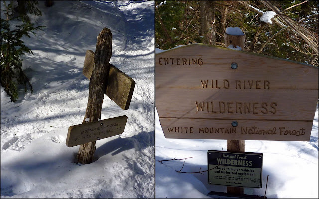
We began our adventure on the Stony Brook Trail and followed it for the entire 3.6 miles to the junction with the Carter-Moriah Trail. Travelling along the Stony Brook Trail as well as the Carter-Moriah Trail was easy. Several groups of hikers on the days preceding our hike had tramped out these trails wearing snowshoes, and some had even pulled flat-bottomed sleds behind them that were laden with supplies for overnight camping. However, the snow on either side of the well-packed trail was deep. This was particularly evident when we encountered a trail signpost. We've all experienced it, but nonetheless I still find it sort of amusing to be looking DOWN at the signs that are normally at eye-level or higher.
Once we reached the junction with the Carter-Moriah Trail, we made a left turn and headed in the direction of Mt. Moriah, although that was NOT our destination. Our target for this particular day was a tier of bare ledges located about 0.4 mile from the Stony Brook Trail junction. These open ledges were also a result of the forest fire of 1895. For a modest amount of effort you are rewarded with dramatic views of the Northern Presidentials, as well as a unique view of ridges and peaks in the Carter Range.
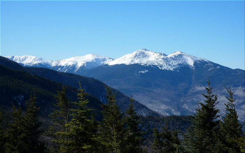
Looking eastward from these ledges, there is an outstanding vista of the vast wilderness areas of the Moriah Brook Valley and the Wild River Valley. The ever-impressive Baldface Mountains are also a prominent feature as you look eastward. If you want to read more about this particular "nameless destination" located on the Carter-Moriah Trail, there is a terrific description with loads of details in the book entitled "Snowshoe Hikes in the White Mountains" by Steven D. Smith.
Before leaving the nameless ledges along the Carter-Moriah Trail, we studied the massive display of bare rock and ledges located on the north side of the Moriah Brook Valley (just a few tenths of a mile off the west end of the Moriah Brook Trail). This area would be our next and final "nameless destination" on this fabulous winter day.
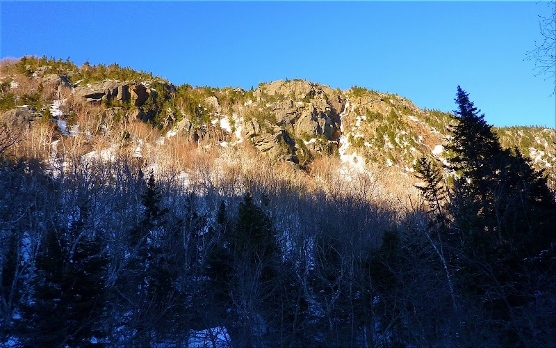
We began this next phase of our trek by hiking for a few tenths of a mile along the Moriah Brook Trail and then eventually departed from the trail for a bushwhack. However, before leaving the trail, we passed through an area of low-growing scrubby vegetation. From here we got an awesome view of the gigantic south cliffs of Mt. Moriah. It almost seemed like a scene you'd expect to see in certain areas of the Western U.S. rather than in the White Mountains of NH!
Once we left the trail we were soon bushwhacking our way through an attractive forest of young birch.
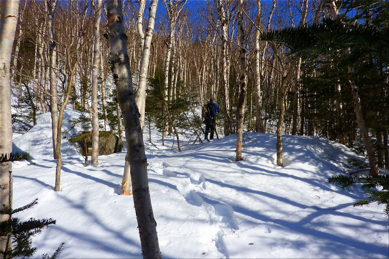
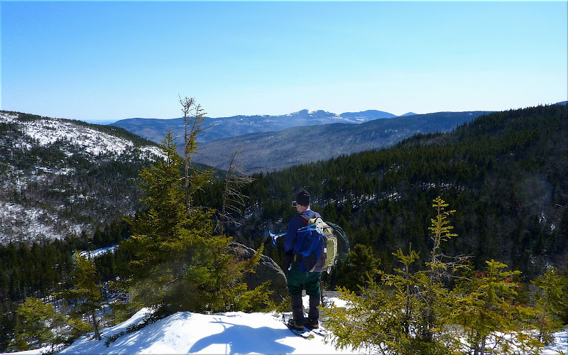
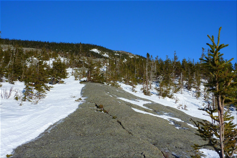
The birch forest eventually gave way to areas of mixed conifers as we approached the first of several ledges that we visited along the way. Since the bushwhacking proved easier than anticipated, we continued upward for a few tenths of a mile to the crest of the ridge where there is an enormous field of bare rock with only a few widely scattered clusters of conifers here and there (see photo below). This huge area was also a result of the 1895 fire mentioned earlier. It covers several acres and is basically a wide-open space that provides sweeping vistas which are simply stunning!
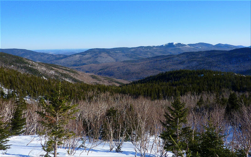
The ledges we had visited earlier in the day along the Carter-Moriah Trail provided a great view into the Wild River Wilderness. However, this open field of rock provided a view of the Wilderness that was even more dramatic since it was more close-up and intimate, as was the gorgeous view of the Baldfaces and surrounding mountains. We also enjoyed looking back at the cliffs and ledges adjacent to the Carter-Moriah Trail where we had been earlier in the day.
With so few trees to block the numbing Arctic-like wind, we were quickly dissuaded from lingering for very long at this fascinating spot.
In a way, this was a good thing. It was late in the day, and we didn't have a lot of time to spare if we wanted to arrive back at the trailhead at a reasonable hour. It was a reluctant departure, but we knew it was time to go. And so, we returned to the Moriah Brook Trail by following the snowshoe tracks we had created during our bushwhack up to the ridge crest. Then, it was a simple matter of linking up with the Stony Brook Trail for the return leg of our journey.
We arrived at the trailhead just shortly after the sun had set. It had been a full day and an enjoyable day. Although the destinations we visited were lacking a name, they certainly were not lacking in beauty!
1HappyHiker
Several nameless destinations near Mt. Moriah were the focus of a recent adventure undertaken by my friend Steve and me on a sunny February day when the air temperature never rose above freezing! However, there was a time back around 1895 when the temperature in this area was sizzling as a raging forest fire consumed over 4,000 acres in the Moriah Brook Valley and along the southeastern ridge of Mt. Moriah. Fires such as this cause tragic losses to flora and fauna, and then erosion washes away much of the soil that might have supported reforestation. Every responsible person abhors the devastation caused by massive forest fires. However, it is somewhat ironic that the destructive fires of the past served to create the views that are now so enjoyed at popular destinations such as Mt. Chocorua, Mt. Crawford, the Moats, the Baldfaces, and many others (including the nameless spots that Steve and I visited).
We began our adventure on the Stony Brook Trail and followed it for the entire 3.6 miles to the junction with the Carter-Moriah Trail. Travelling along the Stony Brook Trail as well as the Carter-Moriah Trail was easy. Several groups of hikers on the days preceding our hike had tramped out these trails wearing snowshoes, and some had even pulled flat-bottomed sleds behind them that were laden with supplies for overnight camping. However, the snow on either side of the well-packed trail was deep. This was particularly evident when we encountered a trail signpost. We've all experienced it, but nonetheless I still find it sort of amusing to be looking DOWN at the signs that are normally at eye-level or higher.
Once we reached the junction with the Carter-Moriah Trail, we made a left turn and headed in the direction of Mt. Moriah, although that was NOT our destination. Our target for this particular day was a tier of bare ledges located about 0.4 mile from the Stony Brook Trail junction. These open ledges were also a result of the forest fire of 1895. For a modest amount of effort you are rewarded with dramatic views of the Northern Presidentials, as well as a unique view of ridges and peaks in the Carter Range.
Looking eastward from these ledges, there is an outstanding vista of the vast wilderness areas of the Moriah Brook Valley and the Wild River Valley. The ever-impressive Baldface Mountains are also a prominent feature as you look eastward. If you want to read more about this particular "nameless destination" located on the Carter-Moriah Trail, there is a terrific description with loads of details in the book entitled "Snowshoe Hikes in the White Mountains" by Steven D. Smith.
Before leaving the nameless ledges along the Carter-Moriah Trail, we studied the massive display of bare rock and ledges located on the north side of the Moriah Brook Valley (just a few tenths of a mile off the west end of the Moriah Brook Trail). This area would be our next and final "nameless destination" on this fabulous winter day.
We began this next phase of our trek by hiking for a few tenths of a mile along the Moriah Brook Trail and then eventually departed from the trail for a bushwhack. However, before leaving the trail, we passed through an area of low-growing scrubby vegetation. From here we got an awesome view of the gigantic south cliffs of Mt. Moriah. It almost seemed like a scene you'd expect to see in certain areas of the Western U.S. rather than in the White Mountains of NH!
Once we left the trail we were soon bushwhacking our way through an attractive forest of young birch.
The birch forest eventually gave way to areas of mixed conifers as we approached the first of several ledges that we visited along the way. Since the bushwhacking proved easier than anticipated, we continued upward for a few tenths of a mile to the crest of the ridge where there is an enormous field of bare rock with only a few widely scattered clusters of conifers here and there (see photo below). This huge area was also a result of the 1895 fire mentioned earlier. It covers several acres and is basically a wide-open space that provides sweeping vistas which are simply stunning!
The ledges we had visited earlier in the day along the Carter-Moriah Trail provided a great view into the Wild River Wilderness. However, this open field of rock provided a view of the Wilderness that was even more dramatic since it was more close-up and intimate, as was the gorgeous view of the Baldfaces and surrounding mountains. We also enjoyed looking back at the cliffs and ledges adjacent to the Carter-Moriah Trail where we had been earlier in the day.
With so few trees to block the numbing Arctic-like wind, we were quickly dissuaded from lingering for very long at this fascinating spot.
In a way, this was a good thing. It was late in the day, and we didn't have a lot of time to spare if we wanted to arrive back at the trailhead at a reasonable hour. It was a reluctant departure, but we knew it was time to go. And so, we returned to the Moriah Brook Trail by following the snowshoe tracks we had created during our bushwhack up to the ridge crest. Then, it was a simple matter of linking up with the Stony Brook Trail for the return leg of our journey.
We arrived at the trailhead just shortly after the sun had set. It had been a full day and an enjoyable day. Although the destinations we visited were lacking a name, they certainly were not lacking in beauty!
1HappyHiker
Last edited:
 For those wanting a more detailed report check out Steve Smith's blog at Mountain Wanderer Web Site. No disrespect to John .... Steve provides more detail on route to the ledges.


