
1HappyHiker
Well-known member
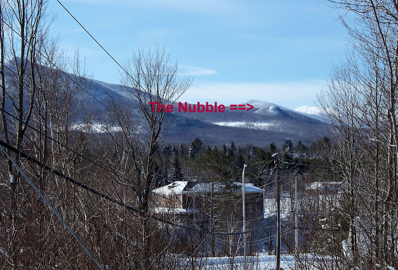
Most of you have seen it, and probably some of you have been there. I’m talking about that little 2,713 ft. peak that sits out there all alone by its self. It’s sort of the third man on the totem pole after North Twin and after the Peak Above the Nubble (PAtN). On many maps this peak is labeled as Haystack Mountain, but most people I know call it “The Nubble”. In a further attempt to describe this peak, below is a photo of The Nubble as seen looking south from the Twin Mountain information kiosk at the intersection of Routes 3 & 302.
Anyway, due to a mid-afternoon commitment, my hiking time was somewhat limited today and so I didn’t want to spend a lot of time on the road driving to a trailhead. Since I live just up the road in Bethlehem, I opted to make the short drive to the Beaver Brook parking lot on Route 3 and do a hike to The Nubble.
I’ve done this hike in the summer many times. Then it’s even a shorter hike since you can drive past the turn-off for the Gale River Trail and continue up the hill (east) on the Gale River Loop Road and park in a cul-de-sac area where the road ends at a gate. However, in the winter, you need to tack on considerable time to traverse the X-C ski trail and then walk the Gale River Loop Road up to a point where you can head off into the woods toward The Nubble.
So after doing the X-C ski trail plus the road walk (which is a snowmobile trail in winter), I came to the point where I normally head off into the woods for The Nubble. From this point forward I was snowshoeing on un-trodden snow which was several feet deep. I think they call this breaking trail! But, that was a given, and it was fine with me. I felt that even if I’d opted for hike today on a conventional trail, there would’ve been a good chance that I’d be breaking trail anyway.
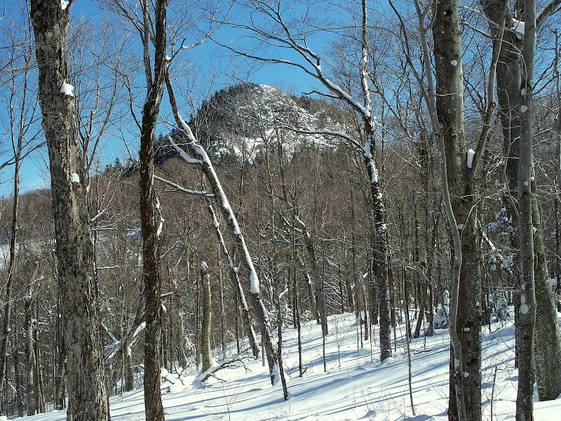
In the summer months, there is a bootleg trail/herd path that’s fairly easy to follow to The Nubble. However, in winter I usually just navigate by “feel”. In winter, as you hike along, you can see The Nubble off to your left through the trees, and so it’s sort of hard to go wrong (see photo below).
As I was “winter-whacking” my way to The Nubble I was struck by the fact that I saw no animal tracks whatsoever. It was sort of like the “Night Before Christmas” story, i.e. not a creature was stirring, not even a mouse! Well, all that was true until I was within a few hundred yards of the base of The Nubble. At this point there is a very narrow pathway through tightly-packed scrub. So, you’re sort of sandwiched between this thick scrub on your right and the steep slopes of The Nubble on your immediate left.
In a way, this pathway is sort of cozy. Actually, it’s so cozy and protected from the wind that the moose love it. Any time of year that I’ve been to this spot, there is ample evidence of moose (scat, hoof prints, etc). Today was no exception. Fresh in my mind was Rocket21’s recent report of the moose gone-wild at Zealand. So, not wanting to meet a moose in this narrow passageway with no escape route, I thought I might scare-off any moose by having a loud conversation with myself. “Hi, how are you doing today?” “I’m doing great!” “How about you?” “Hey, have you heard any moose jokes lately?” Well anyway, you get the point. I guess you could say I was sort of engaging in a “wild-moose chase”, or you could just say that I’ve become 1NuttyHiker.
Well, having survived “moose-alley” unscathed, I slowly and carefully started to make my way up the steep and ledgy slopes of The Nubble. To get all the way to the top of The Nubble is a bit dicey even in summer. However, in winter it can be extremely dicey with deep snow & ice on the rock-face. Since I was hiking alone, I choose to err on the side of caution and go only as far as I felt safe. I actually made it to within literally a few feet of the top, but the final push to the top involved some maneuvers outside my comfort zone.
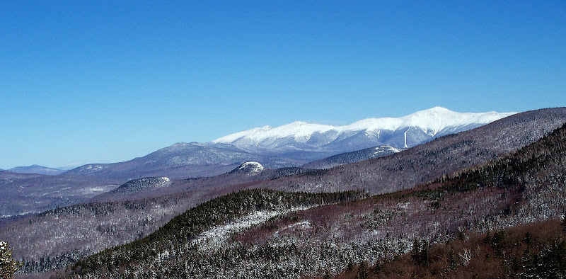
Even without going all the way to the top to get the 360˚ views, you can still get some great eastward views toward the Presidentials with North and Middle Sugarloaf in the foreground (see photo below).
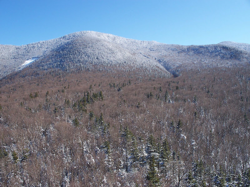
And although not a particularly awe-inspiring scene, you’ve got PAtN right in your face to the south (photo below).
BOTTOM-LINE: Even with a compressed time-frame for hiking today, I was still able to get outside on a beautiful weather day, and do a hike that was very satisfying.
1HappyHiker
Anyway, due to a mid-afternoon commitment, my hiking time was somewhat limited today and so I didn’t want to spend a lot of time on the road driving to a trailhead. Since I live just up the road in Bethlehem, I opted to make the short drive to the Beaver Brook parking lot on Route 3 and do a hike to The Nubble.
I’ve done this hike in the summer many times. Then it’s even a shorter hike since you can drive past the turn-off for the Gale River Trail and continue up the hill (east) on the Gale River Loop Road and park in a cul-de-sac area where the road ends at a gate. However, in the winter, you need to tack on considerable time to traverse the X-C ski trail and then walk the Gale River Loop Road up to a point where you can head off into the woods toward The Nubble.
So after doing the X-C ski trail plus the road walk (which is a snowmobile trail in winter), I came to the point where I normally head off into the woods for The Nubble. From this point forward I was snowshoeing on un-trodden snow which was several feet deep. I think they call this breaking trail!
But, that was a given, and it was fine with me. I felt that even if I’d opted for hike today on a conventional trail, there would’ve been a good chance that I’d be breaking trail anyway.In the summer months, there is a bootleg trail/herd path that’s fairly easy to follow to The Nubble. However, in winter I usually just navigate by “feel”. In winter, as you hike along, you can see The Nubble off to your left through the trees, and so it’s sort of hard to go wrong (see photo below).
As I was “winter-whacking” my way to The Nubble I was struck by the fact that I saw no animal tracks whatsoever. It was sort of like the “Night Before Christmas” story, i.e. not a creature was stirring, not even a mouse! Well, all that was true until I was within a few hundred yards of the base of The Nubble. At this point there is a very narrow pathway through tightly-packed scrub. So, you’re sort of sandwiched between this thick scrub on your right and the steep slopes of The Nubble on your immediate left.
In a way, this pathway is sort of cozy. Actually, it’s so cozy and protected from the wind that the moose love it. Any time of year that I’ve been to this spot, there is ample evidence of moose (scat, hoof prints, etc). Today was no exception. Fresh in my mind was Rocket21’s recent report of the moose gone-wild at Zealand. So, not wanting to meet a moose in this narrow passageway with no escape route, I thought I might scare-off any moose by having a loud conversation with myself. “Hi, how are you doing today?” “I’m doing great!” “How about you?” “Hey, have you heard any moose jokes lately?” Well anyway, you get the point. I guess you could say I was sort of engaging in a “wild-moose chase”, or you could just say that I’ve become 1NuttyHiker.
Well, having survived “moose-alley” unscathed, I slowly and carefully started to make my way up the steep and ledgy slopes of The Nubble. To get all the way to the top of The Nubble is a bit dicey even in summer. However, in winter it can be extremely dicey with deep snow & ice on the rock-face. Since I was hiking alone, I choose to err on the side of caution and go only as far as I felt safe. I actually made it to within literally a few feet of the top, but the final push to the top involved some maneuvers outside my comfort zone.
Even without going all the way to the top to get the 360˚ views, you can still get some great eastward views toward the Presidentials with North and Middle Sugarloaf in the foreground (see photo below).
And although not a particularly awe-inspiring scene, you’ve got PAtN right in your face to the south (photo below).
BOTTOM-LINE: Even with a compressed time-frame for hiking today, I was still able to get outside on a beautiful weather day, and do a hike that was very satisfying.
1HappyHiker
Last edited: