
The Feathered Hat
Active member
Beginning in 1965, the poet Gary Snyder has hosted some friends on an annual circumambulation of Mt. Tamalpais in Marin County, California, emulating the circumambulations of Mt. Fuji in Japan made by Buddhist monks. The Snyder-led hikes still continue, and his group has in the past included Allen Ginsburg, Lawrence Ferlinghetti, Gregory Corso and other notable personalities of the Beat and Counterculture eras. While I was out in California visiting family and friends this past week, my old hiking pal Bart asked me if I wanted to spend a day following the Snyder route. Of course!
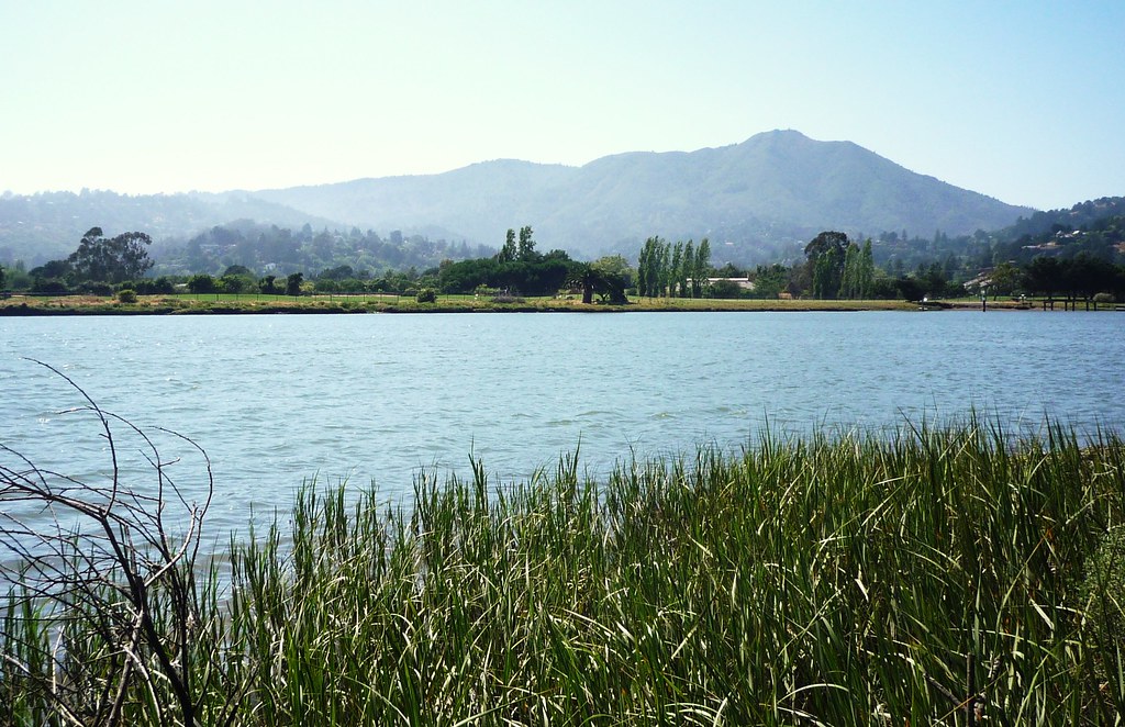
Here's a photo of Mt. Tamalpais rising behind the town of Mill Valley, about a half-hour north of the Golden Gate Bridge:
Tamalpais -- pronounced "tam-ul-pie-us", but everyone calls it Mt. Tam -- is my "home" mountain. I grew up in Mill Valley (way back before it became the wealthy and exclusive community it is today), and when I was about 14 years old I began exploring the mountain with a couple of friends. Packing bag lunches and sometimes hiking 15-18 miles in a day, we covered just about every inch of the big ridge, which rises more than 2,600 feet up from the Pacific Ocean. Our parents let us do this on our own, thinking hiking on the mountain was a lot safer for teenagers than wandering around the Haight-Ashbury in the city (which, for a time at least, is what we all really wanted to do), but those first hikes on Tam changed my life -- an abiding, life-long love for the mountains was made on Tam's trails. Within a couple of years my friends and I were backpacking by ourselves in the High Sierra, and, in a manner of speaking, it's been all downhill, plus a lot of uphill, from there.
The Snyder circumambulation begins in Muir Woods National Monument, which lies in a valley below Tam's summit. With a warm day predicted, we decided to walk in the un-traditional counter-clockwise direction, which would get us up and over the summit while cool morning air still lingered.
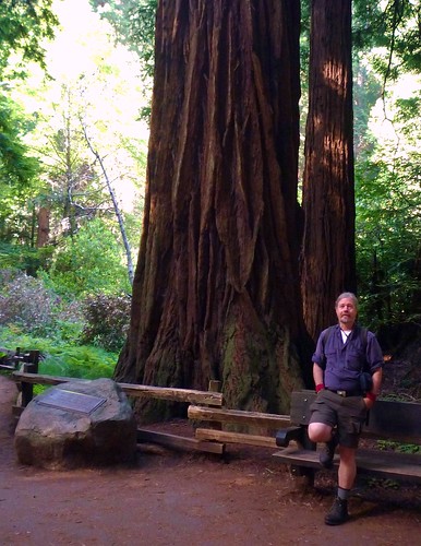
This photo was taken near the trailhead, at the large redwood tree named for the naturalist and conservationist Gifford Pinchot:
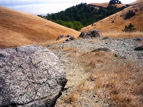
A couple miles up the Ocean View Trail and out of Muir Woods, Bart and I reached the mountain proper:
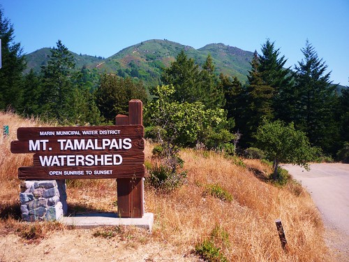
Tam is completely within open space and is protected by a combination of federal, state and local water-district agencies. But these protections are not necessarily absolute -- Mt. Tamalpais State Park is one of those California parks that would be closed under the budget-slashing plan proposed by Gov. Schwarzenegger, and there has been occasional concern that the water district might sell off a parcel or two to raise funds. So far, however, the mountain remains untouched except by trails, several fire roads and one paved road.
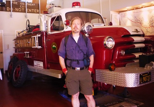
In the summers of 1972, '73 and '74, when I was a teen, I worked as an assistant fireman for the Marin County Fire Department and lived at the Throckmorton Ridge station on Mt. Tam, which wasn't nearly so nice then as it is now:
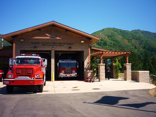
We fought a few wildfires, busted a few illegal campers, rescued quite a few hikers in need (sprained ankles, one broken leg that a remember, and some heat strokes) and hauled out a couple of drug ODs, but mostly we drove around the mountain looking good for the females in our uniforms and big trucks. I learned how to drive a stick-shift in the 1946 International Harvester fire truck we had at the station -- no syncro-mesh back then, this was double-clutching all the way, baby. I was thrilled to discover that all these years later the firemen now at Throckmorton Ridge are restoring that very truck:
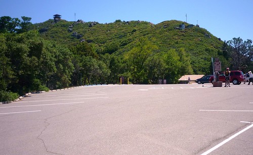
Bart and I reached the summit of Tam via the Fern Creek Trail, which concludes at the parking lot at the top. The mountain's distinguishing fire lookout at the summit is clearly seen here:
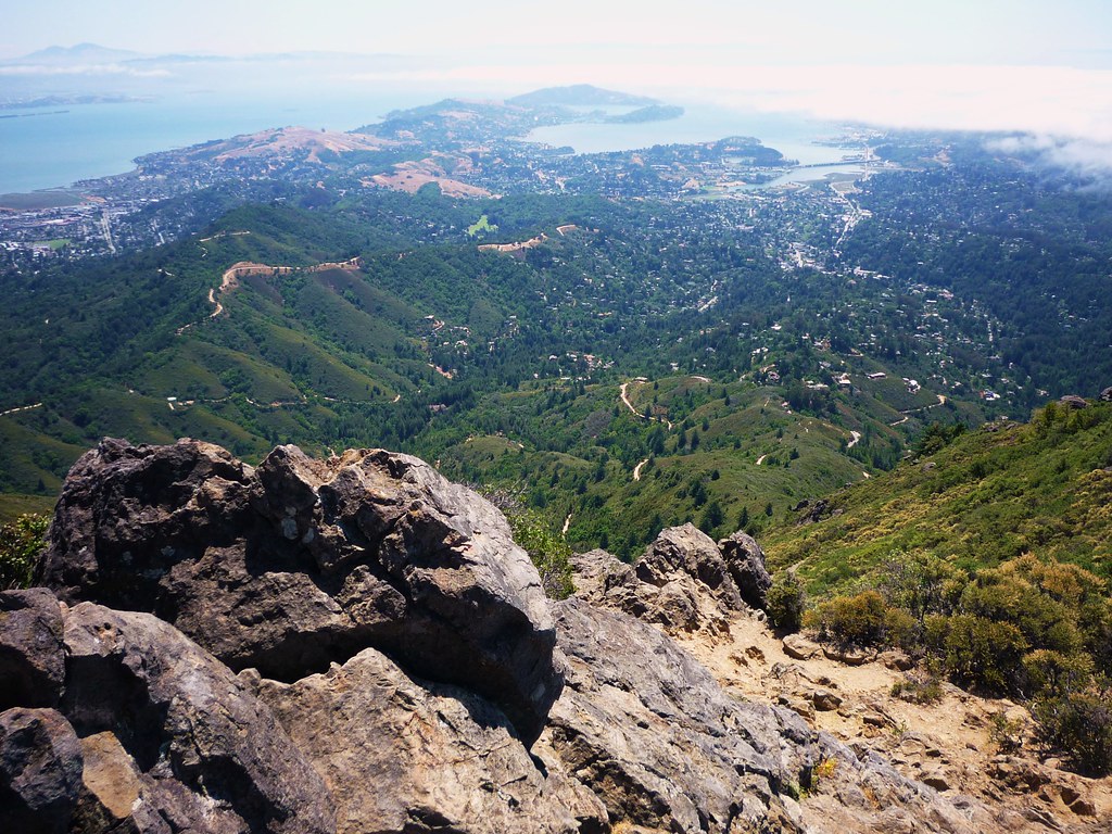
The (literal) VFTT -- that's Angel Island in San Francisco Bay at top center, just beyond the reach of incoming fog:
Surely mine isn't the first pair of Limmers that has been at the top of Tam, but I'll bet this is the first time a VFTT t-shirt has made it:
Tam is famous, among other reasons, as a birthplace of mountain-biking (some say *the* birthplace). Gary Fisher, Otis Guy and Joe Breeze, who all went on to fame (if not fortune) as mountain-bike pioneers, were all local Marin County guys (Joe was a year ahead of me at Tamalpais High School in Mill Valley). They had time on their hands and invention in their hearts and Tam was the ideal laboratory: not only is the mountain latticed with fire roads, but from 1896 until 1930 a train, the so-called "Crookedest Railroad in the World," had steamed up to the top of the mountain from Mill Valley (with a spur down to Muir Woods), and the old railroad grade remained. It was, and still is, ideal for mountain biking. Steeper and thus much more challenging for the early mountain bikers was Eldridge Grade, which Bart and I used to drop over to the backside of the mountain.
We pressed on through Rifle Camp (established by the Civilian Conservation Corps in the 1930s), around Potrero Meadow to Rock Spring (another CCC site) and beyond. Along the way we crossed several serpentine outcroppings, which are part of Tam's somewhat unusual, mish-mashy geology. Serpentine doesn't break down into soil very easily; the outcroppings are like scabs on the skin of the mountain:
After reaching the Pantoll ranger station (if you've ever been to Stinson Beach, you've probably driven past it), Bart and I met the Dipsea Trail at a junction, which would be our route back down into Muir Woods. The Dipsea has been used for an annual footrace from Mill Valley to Stinson Beach that dates back to 1905 and is one of the oldest continunously run footraces in the U.S. (only the Boston Marathon is older, in fact).

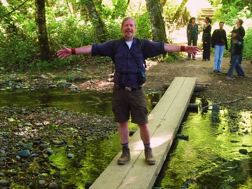
Almost exactly nine hours -- and 15.5 miles -- after we started, Bart and I were back in Muir Woods, our Poet's Walk complete:
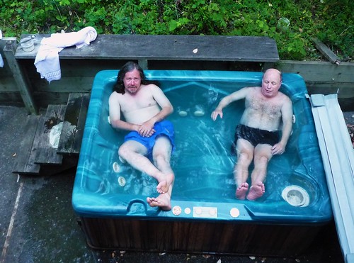
And this being California, there is only one truly proper way to restore body and soul after such a hike:
Trails: Ocean View, Hogsback, Fern Creek, Eldridge Grade, Northside, Benstein, Old Mine, Dipsea
Miles: 15.5
Time: 9 hours (to the minute, in fact)
No. of people seen: Oh god. Millions.
Cellphone coverage: Everywhere (AT&T and Verizon).
More photos:
http://www.flickr.com/photos/99682097@N00/sets/72157621040457554/
Steve B
The Feathered Hat
[email protected]
____________________________________
Tuckerman's report for dogs:
Big Boss Man left me behind in New Hampshire! WTF?
Here's a photo of Mt. Tamalpais rising behind the town of Mill Valley, about a half-hour north of the Golden Gate Bridge:
Tamalpais -- pronounced "tam-ul-pie-us", but everyone calls it Mt. Tam -- is my "home" mountain. I grew up in Mill Valley (way back before it became the wealthy and exclusive community it is today), and when I was about 14 years old I began exploring the mountain with a couple of friends. Packing bag lunches and sometimes hiking 15-18 miles in a day, we covered just about every inch of the big ridge, which rises more than 2,600 feet up from the Pacific Ocean. Our parents let us do this on our own, thinking hiking on the mountain was a lot safer for teenagers than wandering around the Haight-Ashbury in the city (which, for a time at least, is what we all really wanted to do), but those first hikes on Tam changed my life -- an abiding, life-long love for the mountains was made on Tam's trails. Within a couple of years my friends and I were backpacking by ourselves in the High Sierra, and, in a manner of speaking, it's been all downhill, plus a lot of uphill, from there.
The Snyder circumambulation begins in Muir Woods National Monument, which lies in a valley below Tam's summit. With a warm day predicted, we decided to walk in the un-traditional counter-clockwise direction, which would get us up and over the summit while cool morning air still lingered.
This photo was taken near the trailhead, at the large redwood tree named for the naturalist and conservationist Gifford Pinchot:
A couple miles up the Ocean View Trail and out of Muir Woods, Bart and I reached the mountain proper:
Tam is completely within open space and is protected by a combination of federal, state and local water-district agencies. But these protections are not necessarily absolute -- Mt. Tamalpais State Park is one of those California parks that would be closed under the budget-slashing plan proposed by Gov. Schwarzenegger, and there has been occasional concern that the water district might sell off a parcel or two to raise funds. So far, however, the mountain remains untouched except by trails, several fire roads and one paved road.
In the summers of 1972, '73 and '74, when I was a teen, I worked as an assistant fireman for the Marin County Fire Department and lived at the Throckmorton Ridge station on Mt. Tam, which wasn't nearly so nice then as it is now:
We fought a few wildfires, busted a few illegal campers, rescued quite a few hikers in need (sprained ankles, one broken leg that a remember, and some heat strokes) and hauled out a couple of drug ODs, but mostly we drove around the mountain looking good for the females in our uniforms and big trucks. I learned how to drive a stick-shift in the 1946 International Harvester fire truck we had at the station -- no syncro-mesh back then, this was double-clutching all the way, baby. I was thrilled to discover that all these years later the firemen now at Throckmorton Ridge are restoring that very truck:
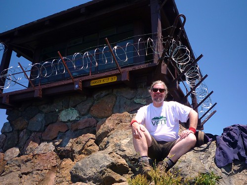
Bart and I reached the summit of Tam via the Fern Creek Trail, which concludes at the parking lot at the top. The mountain's distinguishing fire lookout at the summit is clearly seen here:
The (literal) VFTT -- that's Angel Island in San Francisco Bay at top center, just beyond the reach of incoming fog:
Surely mine isn't the first pair of Limmers that has been at the top of Tam, but I'll bet this is the first time a VFTT t-shirt has made it:
Tam is famous, among other reasons, as a birthplace of mountain-biking (some say *the* birthplace). Gary Fisher, Otis Guy and Joe Breeze, who all went on to fame (if not fortune) as mountain-bike pioneers, were all local Marin County guys (Joe was a year ahead of me at Tamalpais High School in Mill Valley). They had time on their hands and invention in their hearts and Tam was the ideal laboratory: not only is the mountain latticed with fire roads, but from 1896 until 1930 a train, the so-called "Crookedest Railroad in the World," had steamed up to the top of the mountain from Mill Valley (with a spur down to Muir Woods), and the old railroad grade remained. It was, and still is, ideal for mountain biking. Steeper and thus much more challenging for the early mountain bikers was Eldridge Grade, which Bart and I used to drop over to the backside of the mountain.
We pressed on through Rifle Camp (established by the Civilian Conservation Corps in the 1930s), around Potrero Meadow to Rock Spring (another CCC site) and beyond. Along the way we crossed several serpentine outcroppings, which are part of Tam's somewhat unusual, mish-mashy geology. Serpentine doesn't break down into soil very easily; the outcroppings are like scabs on the skin of the mountain:
After reaching the Pantoll ranger station (if you've ever been to Stinson Beach, you've probably driven past it), Bart and I met the Dipsea Trail at a junction, which would be our route back down into Muir Woods. The Dipsea has been used for an annual footrace from Mill Valley to Stinson Beach that dates back to 1905 and is one of the oldest continunously run footraces in the U.S. (only the Boston Marathon is older, in fact).
Almost exactly nine hours -- and 15.5 miles -- after we started, Bart and I were back in Muir Woods, our Poet's Walk complete:
And this being California, there is only one truly proper way to restore body and soul after such a hike:
Trails: Ocean View, Hogsback, Fern Creek, Eldridge Grade, Northside, Benstein, Old Mine, Dipsea
Miles: 15.5
Time: 9 hours (to the minute, in fact)
No. of people seen: Oh god. Millions.
Cellphone coverage: Everywhere (AT&T and Verizon).
More photos:
http://www.flickr.com/photos/99682097@N00/sets/72157621040457554/
Steve B
The Feathered Hat
[email protected]
____________________________________
Tuckerman's report for dogs:
Big Boss Man left me behind in New Hampshire! WTF?
Last edited:
 , not that we saw any of the windfall; Dad had sold the house many years before.