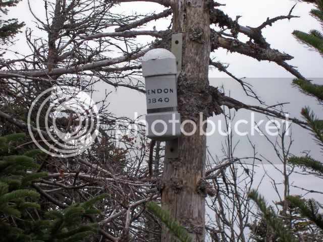
Mendon ??

vftt.org

Help Support vftt.org:

This site may earn a commission from merchant affiliate links, including eBay, Amazon, and others.

funkyfreddy

Well-known member
Joined
Sep 7, 2003
Messages
1,093
Reaction score
230
Location
NYC
Hi, I wondered if any of you have hiked to Mendon from Little Killington or Killington. It looks like the height of land just near the Little Killington viewpoint marked on the Long Trail map might be a way to get there. I was planning on going up the Bucklin trail to Killington then over to Little Killington and from there to Mendon. Would you recommend this route? Is the canister still there? Thanks, Fred
 
Spencer from NY did several years ago. I recall hearing not-good things about it.

The better route starts in the same parking lot: take the old carriage road up to the turn at (I forget the elevation), then it's an easy shot to the false summit (as you approach you'll surely grab a herd path) then herd path to the true summit. Come back to the carriage road, and continue on it (now straight and flat). When it starts to descend, watch for a sharp uphill turn to the right (looks almost like a stream bed due to rocks). Follow that path and it will wind its way up and come out on the LT/AT just south of Cooper Lodge. Then tag the summit and come back down Bucklin to your car.

If you want to do the other direction, Killington first, I'm not sure how well-marked the junction is with that path from the carriage road. It used to have a small (foot-high) cairn.

Side note: the Killington summit lodge is under reconstruction, so there's no shelter or water/bathrooms up there right now that I know of.
 
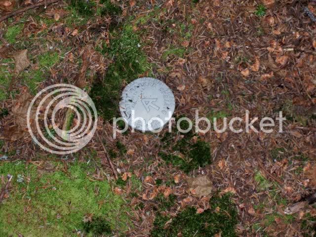
I did it that way back in October of 2006. I went up over Killington and down to the Cooper Hut. I then headed down the trail to get a straight bead on Little Killington and headed in. There were some very thick passages of spruce along the way that were difficult along with an occasional herd path. I think the most fascinating thing I saw was this AT plaque on the top of little Killington. I've often wondered if there were plans at any time to route the trail over that peak.

100_1496-1.jpg


From Killington, the easier approach is the unmarked side trail which turns off to the right a very short distance from Cooper. I say it was unmarked, because there was nothing to indicate what trail it was, but at the time there was a small rock cairn there. It drops you down to the old Carriage road. You follow the road down until you get into the proximity of Mendon and you will see herd trails heading up.
 
Also the Bucklin trail has a pretty major reroute off the stream there that was/is well flagged but if you're coming down from Killington, you will cross the stream and then go uphill away from the old trail and then parallel the stream for quite some time to pretty much about a couple hundred feet from the actual trailhead where you will return to the old trail and then hit the trailhead parking...

Jay
 
The last time I hiked the Long Trail, I tried the bushwhack from the height of land near the little Killington view point. Admittedly it was under less than optimal circumstances. My more detailed map and notes were in my car which was not repositioned as planned to the lot near the Long Trail Inn (my trail angel's plans changed), I went anyways using my compass and the rather sketchy Long Trail map because I had time to kill and was bored. It took me forever as I found myself traveling over massive blowdowns and bulling my way through very thick spruce. I was not too far when I hit my turn around time and given how slow my travel had been, I wasn't tempted to push it. Of course I found some great old trails and nice seams in the growth on my way back and was on the trail in less than 1/4 of the time it took me going out.

Based on all this, it is definitely not the easiest way to go - but some more careful preparation and following the north side of the ridge that extends towards Mendon, it would not be too nasty. I'll definitely try it again sometime.
 
Ed- that's an AT Corridor Boundary Marker - they run the whole length of the AT, on both sides, at regular intervals. They are triangulated by three trees that have yellow painted axe cuts in them, so they may be located during boundary monitoring inspections.

At one time the AT came over Shrewsbury Peak and Little Killington - MichaelJ and I did the traverse from Shrewsbury to Pico about five years ago - the old AT was easy to find and follow at that time.

Good luck with Mendon! I really liked the stamdard approach from
the Wheelerville Rd snow mo trails. Tagging Mendon first then continuing up the old Jeep Rd to the herdpath that connects to the AT is a nice route. There was a cairn at the herdpath about five or six years ago - not sure if it's still there but I do recall the ferns were quite robust in that section and the footpath wasn't easy to spot but it's a very short and open bushwack to the AT:LT.

The Mendon Ridge is really thick according to Spencer as Bryan.
I did it that way back in October of 2006. I went up over Killington and down to the Cooper Hut. I then headed down the trail to get a straight bead on Little Killington and headed in. There were some very thick passages of spruce along the way that were difficult along with an occasional herd path. I think the most fascinating thing I saw was this AT plaque on the top of little Killington. I've often wondered if there were plans at any time to route the trail over that peak.

100_1496-1.jpg

up.
 
Last edited:
Hi, I wondered if any of you have hiked to Mendon from Little Killington or Killington. It looks like the height of land just near the Little Killington viewpoint marked on the Long Trail map might be a way to get there. I was planning on going up the Bucklin trail to Killington then over to Little Killington and from there to Mendon. Would you recommend this route? Is the canister still there? Thanks, Fred

Three years ago the canister was still on Mendon, when I took the following route

http://www.wikiloc.com/wikiloc/view.do?id=469317
 
Top